close
-
Layers w
- Weather Layers
- Pro
- Pro
- Pro
- Pro
- Pro
- Pro
- More Layers
- Pro
- Pro
- Pro
- Pro
-
Upgrade to

3D
Trail Conditions
- Unknown
- Snow Groomed
- Snow Packed
- Snow Covered
- Snow Cover Partial
- Freeze/thaw Cycle
- Icy
- Prevalent Mud
- Wet
- Variable
- Ideal
- Dry
- Very Dry
Trail Flow (Ridden Direction)
Trailforks scans users ridelogs to determine the most popular direction each trail is ridden. A good flowing trail network will have most trails flowing in a single direction according to their intension.
The colour categories are based on what percentage of riders are riding a trail in its intended direction.
The colour categories are based on what percentage of riders are riding a trail in its intended direction.
- > 96%
- > 90%
- > 80%
- > 70%
- > 50%
- < 50%
- bi-directional trail
- no data
Trail Last Ridden
Trailforks scans ridelogs to determine the last time a trail was ridden.
- < 2 days
- < 1 week
- < 2 weeks
- < 1 month
- < 6 months
- > 6 months
Trail Ridden Direction
The intended direction a trail should be ridden.
- Downhill Only
- Downhill Primary
- Both Directions
- Uphill Primary
- Uphill Only
- One Direction
Contribute Details
Colors indicate trail is missing specified detail.
- Description
- Photos
- Description & Photos
- Videos
Trail Popularity ?
Trailforks scans ridelogs to determine which trails are ridden the most in the last 9 months.
Trails are compared with nearby trails in the same city region with a possible 25 colour shades.
Think of this as a heatmap, more rides = more kinetic energy = warmer colors.
- most popular
- popular
- less popular
- not popular
ATV/ORV/OHV Filter
Max Vehicle Width
inches
US Cell Coverage
Legend

Radar Time
Activity Recordings
Trailforks uses anonymized public activity data.
?
Activity Recordings
Trailforks uses anonymized public activity data.
?
Personal Heatmap
▶
Activity Types
all
/
none
▶
Options
2
Date range
month
–
Winter Trails
Warning
A routing network for winter maps does not exist. Selecting trails using the winter trails layer has been disabled.
Missing Trails
Most Popular
Least Popular
Trails are colored based on popularity. The more popular a trail is, the more red. Less popular trails trend towards green.
Jump Magnitude Heatmap
Heatmap of where riders jump on trails. Zoom in to see individual jumps, click circles to view jump details.
BC Backroad Status
![map legend]()
Service Road Atlas is a free to use, community-driven service for viewing and creating reports on the numerous back-country service roads around B.C. and Alberta.

Slope Aspect
Direction the slope faces
Trails Deemphasized
Trails are shown in grey.
Only show trails with no bike usage.
Suggested Layers
Based on selected activity type
Save the current map location and zoom level as your default home location whenever this page is loaded.
Save
No description for Yuen Long has been added yet!
Login or register to submit one.
Activities Click to view
- Mountain Bike
12 trails
- E-Bike
4 trails
- Adaptive Bike
- Hike
10 trails
- Trail Running
9 trails
Region Details
- 1
- 7
Region Status
Open as of Nov 22, 2022Stats
- Avg Trail Rating
- Trails (view details)
- 10
- Trails Mountain Bike
- 12
- Trails E-Bike
- 4
- Trails Hike
- 10
- Trails Trail Running
- 9
- Trails Dirtbike/Moto
- 1
- Total Distance
- 8 miles
- Total Descent Distance
- 6 miles
- Total Descent
- 2,313 ft
- Total Vertical
- 900 ft
- Highest Trailhead
- 928 ft
- Reports
- 2
- Photos
- 6
- Ridden Counter
- 24
Popular Yuen Long Mountain Biking Trails
• 100 ★ 0.0 • 3,406 ft • 364 ft • 10 •
Popular blue difficulty asphalt/tarmac road. This mountain bike primary trail can be used both directions and has a extreme overall physical rating with a 364 ft double black diamond climb. Trail visibility is always easy to follow. On average it takes 9 minutes to complete this trail.
• 5 ★ 4.0 • 3,842 ft • 372 ft • 3 •
Less popular blue difficulty doubletrack. This mountain bike primary trail can be used both directions and has a hard overall physical rating with a 372 ft double black diamond climb. Trail visibility is always easy to follow. On average it takes 14 minutes to complete this trail.
• 90 ★ 0.0 • 2 miles • 0 ft • 3 •
Old army track, needs repair trailwork needed
• 80 ★ 0.0 • 2 miles • 0 ft • 2 • • hike
Overgrown trail created by Brit Army, no washed out in places and often overgrown, but used by hikers
• 5 ★ 0.0 • 3,399 ft • 0 ft • • moto
Less popular blue difficulty singletrack. This dirtbike/moto primary trail can be used downhill primary and has a hard overall physical rating with a 0 ft black diamond climb. Trail visibility is sometimes hard to follow.
Videos of Yuen Long Mountain Bike
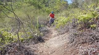
trail: Shorty
0:42 |
80 |
May 19, 2024 , Yuen Long
Recent Trail Reports
| status | trail | date | condition | info | user |
|---|---|---|---|---|---|
| Shorty | Nov 22, 2022 @ 8:38pm Nov 22, 2022 | Variable | grippygravel |
Activity Feed
| username | action | type | title | date |
|---|---|---|---|---|
| dilettantedad | ridden | trail | activity #96834516 | Jun 12, 2026 @ 4:21pm Jun 12, 2026 |
| terrance126 | wishlist | trail | activity #80810558 | Sep 21, 2025 @ 4:38am Sep 21, 2025 |
| grippygravel | add | video | activity #52807242 | May 19, 2024 @ 12:08am May 19, 2024 |
| grippygravel | add | photo | activity #52806771 | May 18, 2024 @ 11:57pm May 18, 2024 |
| Peds0824 | ridden | skillpark | activity #39013459 | Apr 14, 2023 @ 1:11am Apr 14, 2023 |
Local Badges
-

Epic Mountain Bike Climb 2k15 awarded -

Climbing 10k Badge4 awarded -

Mountain Biking 100k Badge1 awarded -

Big Ride 30k133 awarded -

Epic Ride 50k70 awarded
Bike & Skill Parks
| name | type | city | rating |
|---|---|---|---|
| Akki Bike Park | skill park | Yuen Long |
Activity Type Stats
| activitytype | trails | distance | descent | descent distance | total vertical | rating | global rank | state rank | photos | reports | routes | ridelogs |
|---|---|---|---|---|---|---|---|---|---|---|---|---|
| Mountain Bike | 12 | 8 miles | 2,313 ft | 6 miles | 899 ft | #4,394 | #3 | 6 | 2 | 1,244 | ||
| E-Bike | 4 | 1 mile | 249 ft | 2,080 ft | 689 ft | #1,762 | #1 | 2 | 33 | |||
| Hike | 10 | 4 miles | 751 ft | 2 miles | 791 ft | #2,603 | #3 | 2 | 46 | |||
| Trail Running | 9 | 4 miles | 751 ft | 2 miles | 791 ft | #2,172 | #1 | 2 | 618 | |||
| Dirtbike/Moto | 1 | 3,399 ft | 266 ft | 3,399 ft | 266 ft |
Frequently Asked Questions About Yuen Long
▼
What are the highest rated mountain biking trails in Yuen Long?
The highest rated mountain biking trails in Yuen Long are:
- 240 Climb (4/5)
- DB uphill (0/5)
- Deep Bay abandoned trail (0/5)
- Needs work (0/5)
- Deep bay connector (0/5)
▼
What is the best time of the year to ride in Yuen Long?
Based on ride log data, the most popular months to ride in Yuen Long are:
- July (21 activities)
- May (20 activities)
- June (18 activities)
▼
Where can I park to ride in Yuen Long?
Check the Yuen Long trail map for trailhead and parking information. Community members regularly update access and parking details for trails in the area.
▼
What is the longest trail in Yuen Long?
The longest trail in Yuen Long is Deep Bay abandoned trail at 1.8 miles. View all trails sorted by distance.
- By grippygravel
 & contributors
 - Admins: apply
- #53851 - 1,027 views
- yuen long activity log | embed map of Yuen Long mountain bike trails |
Downloading of trail gps tracks in kml & gpx formats is enabled for Yuen Long.
You must login to download files.