close
-
Layers w
- Weather Layers
- Pro
- Pro
- Pro
- Pro
- Pro
- Pro
- More Layers
- Pro
- Pro
- Pro
- Pro
-
Upgrade to

3D
Trail Conditions
- Unknown
- Snow Groomed
- Snow Packed
- Snow Covered
- Snow Cover Partial
- Freeze/thaw Cycle
- Icy
- Prevalent Mud
- Wet
- Variable
- Ideal
- Dry
- Very Dry
Trail Flow (Ridden Direction)
Trailforks scans users ridelogs to determine the most popular direction each trail is ridden. A good flowing trail network will have most trails flowing in a single direction according to their intension.
The colour categories are based on what percentage of riders are riding a trail in its intended direction.
The colour categories are based on what percentage of riders are riding a trail in its intended direction.
- > 96%
- > 90%
- > 80%
- > 70%
- > 50%
- < 50%
- bi-directional trail
- no data
Trail Last Ridden
Trailforks scans ridelogs to determine the last time a trail was ridden.
- < 2 days
- < 1 week
- < 2 weeks
- < 1 month
- < 6 months
- > 6 months
Trail Ridden Direction
The intended direction a trail should be ridden.
- Downhill Only
- Downhill Primary
- Both Directions
- Uphill Primary
- Uphill Only
- One Direction
Contribute Details
Colors indicate trail is missing specified detail.
- Description
- Photos
- Description & Photos
- Videos
Trail Popularity ?
Trailforks scans ridelogs to determine which trails are ridden the most in the last 9 months.
Trails are compared with nearby trails in the same city region with a possible 25 colour shades.
Think of this as a heatmap, more rides = more kinetic energy = warmer colors.
- most popular
- popular
- less popular
- not popular
ATV/ORV/OHV Filter
Max Vehicle Width
inches
US Cell Coverage
Legend

Radar Time
Activity Recordings
Trailforks uses anonymized public activity data.
?
Activity Recordings
Trailforks uses anonymized public activity data.
?
Personal Heatmap
▶
Activity Types
all
/
none
▶
Options
2
Date range
month
–
Winter Trails
Warning
A routing network for winter maps does not exist. Selecting trails using the winter trails layer has been disabled.
Missing Trails
Most Popular
Least Popular
Trails are colored based on popularity. The more popular a trail is, the more red. Less popular trails trend towards green.
Jump Magnitude Heatmap
Heatmap of where riders jump on trails. Zoom in to see individual jumps, click circles to view jump details.
BC Backroad Status
![map legend]()
Service Road Atlas is a free to use, community-driven service for viewing and creating reports on the numerous back-country service roads around B.C. and Alberta.

Slope Aspect
Direction the slope faces
Trails Deemphasized
Trails are shown in grey.
Only show trails with no bike usage.
Suggested Layers
Based on selected activity type
Save the current map location and zoom level as your default home location whenever this page is loaded.
SaveYuncaypata is a small village above Cusco where several trails start.
Primary Trail Type: All-Mountain & Downhill
Shuttleable: YES
Land Status: Community Forest
Activities Click to view
- Mountain Bike
18 trails
- E-Bike
4 trails
- Hike
17 trails
- Trail Running
17 trails
Region Details
- 3
- 12
- 2
Region Status
Caution as of Oct 4, 2025Stats
- Avg Trail Rating
- Trails (view details)
- 17
- Trails Mountain Bike
- 18
- Trails E-Bike
- 4
- Trails Hike
- 17
- Trails Trail Running
- 17
- Total Distance
- 61 miles
- Total Descent
- 40,838 ft
- Total Vertical
- 4,591 ft
- Highest Trailhead
- 14,214 ft
- Reports
- 10
- Photos
- 119
- Ridden Counter
- 406
Popular Yuncaypata Mountain Biking Trails
• 80 ★ 5.0 • 4 miles • 158 ft • 88 •
Starts in the Alpine and has a great view of Cusco city gets in to rocky sections. A lot of ichu (altitude grass).
• 100 ★ 4.5 • 2 miles • 52 ft • 83 •
This is a cool and short trail above Cusco that starts near the Inca site of Puca Pucara. It follows ancient paths down to the city of Cusco. The last part of this ride is through the stairs in the upper part of the city of Cusco.
• 95 ★ 0.0 • 2,320 ft • 4 ft • 40 •
Urban downhill section that can be perfectly added to Huayllarcocha 1 or 2 to end the day and get back into Cusco. Ride carefully, as the streets, paths and stairs are used by pedestrians. Respect the locals, be nice.
• 80 ★ 0.0 • 4 miles • 836 ft • 29 •
Sweet, 90% is easy, the last part gets really steep on a rockface.
• 90 ★ 0.0 • 4 miles • 10 ft • 26 •
Explore the "Picol" trail, nestled at the same elevation as the renowned "El Brujo" route. A recent discovery, this trail offers a unique descent from the Cusco mountains to the city below. Meet "El Pastor," a trail beginning at 4300...
• 85 ★ 0.0 • 2 miles • 89 ft • 17 •
Located just 30 minutes from the city of Cusco, this trail is arguably the most renowned mountain biking route in the city. Riders from the region flock to this spot to revel in biking, enhance their skills, and enjoy multiple descents...
• 5 ★ 4.0 • 8 miles • 425 ft • 17 •
After driving an hour up the canyon from along a winding dirt road, this picturesque singletrack starts high in Alpaca grazing fields and drops down into a canyon that gives glimpses of rural mountain farm life. Stretches of moderate...
• 5 ★ 0.0 • 4,938 ft • 3 ft • 15 •
Short trail near Cusco with loads of man made features, drops, gaps, road gaps and some gnarly steep sections. Very fun and very fast.
Yuncaypata Mountain Bike Routes
• 1 mile • 110 ft • 1 •
• 8 miles • 475 ft • 0 •
• 9 miles • 1,237 ft • 0 •
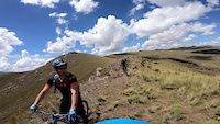
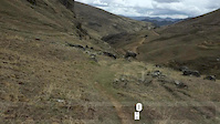
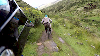
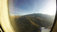
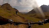
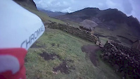
Photos of Yuncaypata Mountain Bike
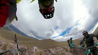
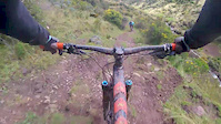
Videos of Yuncaypata Mountain Bike
trail: El Brujo
2:05 |
75 |
Oct 9, 2019
trail: El Brujo
0:09 |
61 |
Nov 19, 2018
trail: Lamay
0:34 |
48 |
Dec 26, 2017
trail: Lamay
2:38 |
88 |
May 10, 2017
trail: Lamay
5:43 |
75 |
Mar 6, 2017
trail: Lamay
17:36 |
65 |
Oct 30, 2016
trail: Lamay
16:06 |
346 |
May 7, 2014
trail: Lamay
6:24 |
520 |
May 19, 2013
Recent Trail Reports
| status | trail | date | condition | info | user |
|---|---|---|---|---|---|
| Lamay | Jul 12, 2022 @ 8:47am Jul 12, 2022 | Dry | inkasadventures | ||
| Huallarcocha 1 | May 18, 2019 @ 12:54pm May 18, 2019 | Variable | jeffnelson19784 | ||
| El Brujo | Jun 30, 2018 @ 2:10pm Jun 30, 2018 | Dry | HakuExpeditions |
Activity Feed
| username | action | type | title | date |
|---|---|---|---|---|
| Rodrigo-Bruschz | ridden | trail | activity #88932633 | Feb 14, 2026 @ 6:51pm Feb 14, 2026 |
| nicoF2AW1F | wishlist | trail | activity #87829234 | Jan 25, 2026 @ 5:34pm Jan 25, 2026 |
| gariel22 | add | photo | activity #85450863 and 1 more | Dec 13, 2025 @ 7:01am Dec 13, 2025 |
| joshmccarthy | wishlist | trail | activity #83510734 and 1 more | Nov 3, 2025 @ 7:55am Nov 3, 2025 |
| erikasp03 | wishlist | trail | activity #77984358 | Aug 12, 2025 @ 11:07am Aug 12, 2025 |
Recent Comments
| username | type | title | comment | date |
|---|---|---|---|---|
| trail | Fun descent (a bit like a Ledgeview style... | May 22, 2024 @ 9:15pm May 22, 2024 | ||
| trail | Awesome views & fun! Lots of grass &... | May 22, 2024 @ 9:14pm May 22, 2024 | ||
| trail | See comment on Lamay; only did the lower... | May 14, 2024 @ 6:00pm May 14, 2024 | ||
| trail | Great fun indeed! Some technical bits. A bit... | May 14, 2024 @ 5:59pm May 14, 2024 | ||
| trail | One of the best trails in Peru. Incredible... | Dec 4, 2023 @ 6:32pm Dec 4, 2023 |
Nearby Areas
| name | distance | ||||
|---|---|---|---|---|---|
| Sacred Valley | 16.2 km | ||||
| Andahuaylillas | 1 | 23.4 km | |||
| Ollantaytambo | 1 | 1 | 28.5 km |
Activity Type Stats
| activitytype | trails | distance | descent | descent distance | total vertical | rating | global rank | state rank | photos | reports | routes | ridelogs |
|---|---|---|---|---|---|---|---|---|---|---|---|---|
| Mountain Bike | 18 | 61 miles | 40,837 ft | 47 miles | 4,590 ft | #1,062 | #1 | 119 | 10 | 1 | 1,210 | |
| E-Bike | 4 | 8 miles | 6,355 ft | 7 miles | 3,163 ft | #1,282 | #3 | 9 | 27 | |||
| Hike | 17 | 54 miles | 37,034 ft | 41 miles | 4,544 ft | #1,029 | #3 | 9 | 208 | |||
| Trail Running | 17 | 54 miles | 37,034 ft | 41 miles | 4,544 ft | #544 | #2 | 9 | 8 |
Frequently Asked Questions About Yuncaypata
▼
What are the highest rated mountain biking trails in Yuncaypata?
The highest rated mountain biking trails in Yuncaypata are:
- El Brujo (4.5/5)
- Balcon del Diablo to main square (4.1/5)
- Huchuy Cusco (4.1/5)
- Huama Lamay (4.1/5)
- Huallarcocha 1 (4.1/5)
▼
What is the best time of the year to ride in Yuncaypata?
Based on ride log data, the most popular months to ride in Yuncaypata are:
- November (21 activities)
- May (4 activities)
- October (4 activities)
▼
Where can I park to ride in Yuncaypata?
Check the Yuncaypata trail map for trailhead and parking information. Community members regularly update access and parking details for trails in the area.
▼
What is the longest trail in Yuncaypata?
The longest trail in Yuncaypata is Huchuy Cusco at 22.1 km. View all trails sorted by distance.
- By inkasadventures & contributors
- Admins: apply
- #7139 - 2,795 views
- yuncaypata activity log | embed map of Yuncaypata mountain bike trails |
Downloading of trail gps tracks in kml & gpx formats is enabled for Yuncaypata.
You must login to download files.