close
-
Layers w
- Weather Layers
- Pro
- Pro
- Pro
- Pro
- Pro
- Pro
- More Layers
- Pro
- Pro
- Pro
- Pro
-
Upgrade to

3D
Trail Conditions
- Unknown
- Snow Groomed
- Snow Packed
- Snow Covered
- Snow Cover Partial
- Freeze/thaw Cycle
- Icy
- Prevalent Mud
- Wet
- Variable
- Ideal
- Dry
- Very Dry
Trail Flow (Ridden Direction)
Trailforks scans users ridelogs to determine the most popular direction each trail is ridden. A good flowing trail network will have most trails flowing in a single direction according to their intension.
The colour categories are based on what percentage of riders are riding a trail in its intended direction.
The colour categories are based on what percentage of riders are riding a trail in its intended direction.
- > 96%
- > 90%
- > 80%
- > 70%
- > 50%
- < 50%
- bi-directional trail
- no data
Trail Last Ridden
Trailforks scans ridelogs to determine the last time a trail was ridden.
- < 2 days
- < 1 week
- < 2 weeks
- < 1 month
- < 6 months
- > 6 months
Trail Ridden Direction
The intended direction a trail should be ridden.
- Downhill Only
- Downhill Primary
- Both Directions
- Uphill Primary
- Uphill Only
- One Direction
Contribute Details
Colors indicate trail is missing specified detail.
- Description
- Photos
- Description & Photos
- Videos
Trail Popularity ?
Trailforks scans ridelogs to determine which trails are ridden the most in the last 9 months.
Trails are compared with nearby trails in the same city region with a possible 25 colour shades.
Think of this as a heatmap, more rides = more kinetic energy = warmer colors.
- most popular
- popular
- less popular
- not popular
ATV/ORV/OHV Filter
Max Vehicle Width
inches
US Cell Coverage
Legend

Radar Time
Activity Recordings
Trailforks uses anonymized public activity data.
?
Activity Recordings
Trailforks uses anonymized public activity data.
?
Personal Heatmap
▶
Activity Types
all
/
none
▶
Options
2
Date range
month
–
Winter Trails
Warning
A routing network for winter maps does not exist. Selecting trails using the winter trails layer has been disabled.
Missing Trails
Most Popular
Least Popular
Trails are colored based on popularity. The more popular a trail is, the more red. Less popular trails trend towards green.
Jump Magnitude Heatmap
Heatmap of where riders jump on trails. Zoom in to see individual jumps, click circles to view jump details.
BC Backroad Status
![map legend]()
Service Road Atlas is a free to use, community-driven service for viewing and creating reports on the numerous back-country service roads around B.C. and Alberta.

Slope Aspect
Direction the slope faces
Trails Deemphasized
Trails are shown in grey.
Only show trails with no bike usage.
Suggested Layers
Based on selected activity type
Save the current map location and zoom level as your default home location whenever this page is loaded.
SaveFor more information on each ride area or trail, scroll down and click on any of the links. Most of the trails that have been mapped in Zambia at this stage, is in the Lusaka area.
If you are new to the Trailforks App, have a look at the Dummies Guide below for information on how to get started.
If you would like to map trails in your area, please message WillieJacobsz in the Trailforks messenger which can be found in the top right hand corner of your computer screen, to the right of the search bar, and I will help you get going.
On Trailforks Zambia is sub divided into its 10 official provinces as per the link below.
Links
- MTB Zambia Facebook Group
- Prozam MTB Supply Facebook Page
- Zambiaraces.com Facebook Group
- Zambia Provinces
Files
Region Supporters & Maintainers
Region Details
- 213
- 1
- 146
- 145
Stats
- Avg Trail Rating
- Trails (view details)
- 520
- Trails Mountain Bike
- 505
- Trails E-Bike
- 492
- Trails Horse
- 1
- Trails Hike
- 506
- Trails Trail Running
- 506
- Trails Dirtbike/Moto
- 35
- Total Distance
- 556 miles
- Total Descent Distance
- 258 miles
- Total Descent
- 43,417 ft
- Total Vertical
- 2,812 ft
- Highest Trailhead
- 5,449 ft
- Reports
- 120
- Photos
- 37
- Ridden Counter
- 1,213
Sub Regions
- Central Province (2)
- Kabwe (1)
- Kabwe (1)
- Copperbelt Province (1)
- Kitwe (1)
- Kitwe (1)
- Eastern Province (1)
- Chipata (1)
- Chipata (1)
- Luapula Province (1)
- Mansa (1)
- Mansa (1)
- Lusaka Province (386)
- Muchinga Province (26)
- North Western Province (85)
- Ikelenge District (38)
- Ikelenge (38)
- Kalimbila District (0)
- Kalumbila (0)
- Mavunda (21)
- Solwezi (47)
- Ikelenge District (38)
- Northern Province (1)
- Kasama (1)
- Kasama (1)
- Southern Province (1)
- Livingstone (1)
- Livingstone (1)
- Western Province (1)
- Mongu (1)
- Mongu (1)
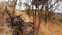
Popular Zambia Mountain Biking Trails
• 95 ★ 0.0 • 856 ft • 2 ft • 10 •
Popular green difficulty singletrack. This multi-use trail can be used both directions and has a easy overall physical rating with a 2 ft green climb. Trail visibility is always easy to follow. On average it takes 6 minutes to complete this trail.
• 80 ★ 5.0 • 2,530 ft • 218 ft • 10 •
Popular blue difficulty singletrack. This multi-use trail can be used both directions and has a moderate overall physical rating with a 218 ft blue climb. Trail visibility is always easy to follow. On average it takes 10 minutes to complete this trail.
• 85 ★ 5.0 • 2 miles • 111 ft • 9 •
Popular blue difficulty singletrack. This multi-use trail can be used both directions and has a moderate overall physical rating with a 111 ft blue climb. Trail visibility is always easy to follow. On average it takes 13 minutes to complete this trail.
• 85 ★ 5.0 • 1 mile • 121 ft • 9 •
Popular blue difficulty singletrack. This multi-use trail can be used both directions and has a moderate overall physical rating with a 121 ft blue climb. Trail visibility is always easy to follow. On average it takes 13 minutes to complete this trail.
• 100 ★ 0.0 • 1,217 ft • 16 ft • 9 •
Popular green difficulty singletrack. This multi-use trail can be used both directions and has a easy overall physical rating with a 16 ft green climb. Trail visibility is always easy to follow. On average it takes 2 minutes to complete this trail.
• 95 ★ 5.0 • 1 mile • 2 ft • 9 •
Popular blue difficulty singletrack. This multi-use trail can be used both directions and has a moderate overall physical rating with a 2 ft blue climb. Trail visibility is always easy to follow. On average it takes 5 minutes to complete this trail.
• 75 ★ 0.0 • 781 ft • 0 ft • 9 •
Popular green difficulty singletrack. This multi-use trail can be used both directions and has a easy overall physical rating with a 0 ft green climb. Trail visibility is always easy to follow. On average it takes 1 minutes to complete this trail.
• 75 ★ 0.0 • 1,010 ft • 7 ft • 9 •
Popular green difficulty singletrack. This multi-use trail can be used both directions and has a easy overall physical rating with a 7 ft green climb. Trail visibility is always easy to follow. On average it takes 2 minutes to complete this trail.
Zambia Mountain Bike Routes
★ 5.0 • 46 miles • 2,065 ft • 0 •
10 miles • 268 ft • 0 • Loop •
A 16 km off-road MTB route with lots of fast slopes and uphills, very good for training or MTB...
33 miles • 3,077 ft • 12 • Loop •
Circular route in escarpment mix of single track trails jeep trails
30 miles • 1,805 ft • 1 • Loop •
32 miles • 324 ft • 0 • Out & Back •
A 50 km Cycling route, for training or casual riding starting from Meanwood Kwamwena to the Airport...
13 miles • 1,638 ft • 0 • Loop •
Videos of Zambia Mountain Bike
trail: Nchilia Main Gate to Pivot
0:11 |
|
Sep 20, 2024
trail: Classic Rock
0:26 |
52 |
Jun 22, 2020

10:17 |
379 |
Mar 10, 2020

2:05 |
544 |
Mar 10, 2020

3:19 |
296 |
Mar 10, 2020

4:20 |
323 |
Mar 10, 2020

3:29 |
368 |
Mar 10, 2020
5:36 |
313 |
Mar 5, 2020
Recent Comments
| username | type | title | comment | date |
|---|---|---|---|---|
| trail | Trail does NOT connect to Mukwa drive.... | Mar 31, 2024 @ 3:10am Mar 31, 2024 | ||
| trail | Trail is blocked by fence mod way and is on... | Mar 31, 2024 @ 3:10am Mar 31, 2024 | ||
| trail | Gate is usually LOCKED at end, cannot exit... | Mar 31, 2024 @ 3:09am Mar 31, 2024 | ||
| trail | Mostly a double track to access Steeps and... | Mar 31, 2024 @ 3:08am Mar 31, 2024 | ||
| trail | Start of trail is a bit hard to find and many... | Mar 31, 2024 @ 3:06am Mar 31, 2024 |
Activity Type Stats
| activitytype | trails | distance | descent | descent distance | total vertical | rating | global rank | state rank | photos | reports | routes | ridelogs |
|---|---|---|---|---|---|---|---|---|---|---|---|---|
| Mountain Bike | 505 | 549 miles | 43,173 ft | 256 miles | 2,812 ft | #58 | 37 | 120 | 13 | 4,505 | ||
| E-Bike | 492 | 541 miles | 43,074 ft | 255 miles | 2,812 ft | #45 | 120 | 9 | 55 | |||
| Horse | 1 | 6 miles | 98 ft | 2 miles | 33 ft | #79 | ||||||
| Hike | 506 | 550 miles | 43,173 ft | 256 miles | 2,812 ft | #50 | 120 | 1 | 156 | |||
| Trail Running | 506 | 550 miles | 43,173 ft | 256 miles | 2,812 ft | #44 | 120 | 50 | ||||
| Dirtbike/Moto | 35 | 33 miles | 1,526 ft | 15 miles | 1,339 ft | #50 | 53 |
Activities
Trails
- By markholloway
 Trailforks Map Team & contributors
 - Admins: WillieJacobsz
- #35807 - 4,773 views
- zambia activity log | embed map of Zambia mountain bike trails | zambia mountain biking points of interest polygons
Downloading of trail gps tracks in kml & gpx formats is enabled for Zambia.
You must login to download files.