close
-
Layers w
- Weather Layers
- Pro
- Pro
- Pro
- Pro
- Pro
- Pro
- More Layers
- Pro
- Pro
- Pro
- Pro
-
Upgrade to

3D
Trail Conditions
- Unknown
- Snow Groomed
- Snow Packed
- Snow Covered
- Snow Cover Partial
- Freeze/thaw Cycle
- Icy
- Prevalent Mud
- Wet
- Variable
- Ideal
- Dry
- Very Dry
Trail Flow (Ridden Direction)
Trailforks scans users ridelogs to determine the most popular direction each trail is ridden. A good flowing trail network will have most trails flowing in a single direction according to their intension.
The colour categories are based on what percentage of riders are riding a trail in its intended direction.
The colour categories are based on what percentage of riders are riding a trail in its intended direction.
- > 96%
- > 90%
- > 80%
- > 70%
- > 50%
- < 50%
- bi-directional trail
- no data
Trail Last Ridden
Trailforks scans ridelogs to determine the last time a trail was ridden.
- < 2 days
- < 1 week
- < 2 weeks
- < 1 month
- < 6 months
- > 6 months
Trail Ridden Direction
The intended direction a trail should be ridden.
- Downhill Only
- Downhill Primary
- Both Directions
- Uphill Primary
- Uphill Only
- One Direction
Contribute Details
Colors indicate trail is missing specified detail.
- Description
- Photos
- Description & Photos
- Videos
Trail Popularity ?
Trailforks scans ridelogs to determine which trails are ridden the most in the last 9 months.
Trails are compared with nearby trails in the same city region with a possible 25 colour shades.
Think of this as a heatmap, more rides = more kinetic energy = warmer colors.
- most popular
- popular
- less popular
- not popular
ATV/ORV/OHV Filter
Max Vehicle Width
inches
US Cell Coverage
Legend

Radar Time
Activity Recordings
Trailforks uses anonymized public activity data.
?
Activity Recordings
Trailforks uses anonymized public activity data.
?
Personal Heatmap
▶
Activity Types
all
/
none
▶
Options
2
Date range
month
–
Winter Trails
Warning
A routing network for winter maps does not exist. Selecting trails using the winter trails layer has been disabled.
Missing Trails
Most Popular
Least Popular
Trails are colored based on popularity. The more popular a trail is, the more red. Less popular trails trend towards green.
Jump Magnitude Heatmap
Heatmap of where riders jump on trails. Zoom in to see individual jumps, click circles to view jump details.
BC Backroad Status
![map legend]()
Service Road Atlas is a free to use, community-driven service for viewing and creating reports on the numerous back-country service roads around B.C. and Alberta.

Slope Aspect
Direction the slope faces
Trails Deemphasized
Trails are shown in grey.
Only show trails with no bike usage.
Suggested Layers
Based on selected activity type
Save the current map location and zoom level as your default home location whenever this page is loaded.
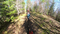
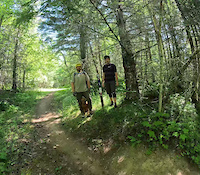
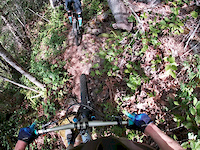
SaveRemote singletrack trails that utilize the terrain's natural features with an emphasis on descending that are easily accessible from Port Angeles. There is a little bit of everything in this network aside from built features. Climbing is generally steep and involves fire roads, descending is usually chunky and physically demanding. A network that is easy to get a lot of vertical in relatively short distance. Be prepared for a physically demanding ride on the way up and down. Parking is available at the lot near the Colville skills park or off of Eden Valley Road near Alpaca.
Primary Trail Type: All-Mountain & Downhill
eBikes Allowed:
No
 google parking directions
Links
Activities Click to view
- Mountain Bike
65 trails
- E-Bike
24 trails
- Hike
39 trails
- Trail Running
41 trails
- Dirtbike/Moto
14 trails
Region Details
- 9
- 2
- 15
- 8
- 5
Region Status
Open as of 2 daysStats
- Avg Trail Rating
- Trails (view details)
- 38
- Trails Mountain Bike
- 68
- Trails E-Bike
- 24
- Trails Hike
- 40
- Trails Trail Running
- 41
- Trails Dirtbike/Moto
- 15
- Total Distance
- 16 miles
- Total Descent
- 7,785 ft
- Total Vertical
- 1,548 ft
- Highest Trailhead
- 2,123 ft
- Reports
- 277
- Photos
- 155
- Ridden Counter
- 4,921
Popular The Zoo Mountain Biking Trails
• 85 ★ 4.7 • 1 mile • 16 ft • 222 •
THE original downhill trail off of Kelly Peak. Very fast with a mix of roots and open sections, some drops and optional jumps. Larger features have ride arounds. There is a new section near the bottom that has some large berms and a...
• 80 ★ 4.2 • 4,639 ft • 50 ft • 165 •
Once past the steep entrance chute, feast on smooth, winding, single track with several small, optional jumps. After a short climb halfway down, the trail turns more technical with multiple small, rollable root and log drops.
• 95 ★ 4.7 • 1,585 ft • 0 ft • 164 •
A smooth trail that can be ridden at an easy pace or at high speed. Lots of rollable jumps and drops.
• 95 ★ 4.0 • 935 ft • 56 ft • 161 •
Sketchy. Trail splits at the top into two lines. The left split is the easier of the two, the right has an off camber cliff face that should be looked at before attempting.
• 85 ★ 4.8 • 4,905 ft • 0 ft • 143 •
A very unique trail, the ridge section is almost entirely rock which is extremely grippy. There are some steep technical rock rolls and faces, the most noteworthy being about halfway down the trail and is worth taking a look at as it...
• 90 ★ 4.5 • 3,698 ft • 2 ft • 138 •
Low angle trail that can be ridden at high speed with a bit of effort but can also be cruised. All features are rollable.
• 70 ★ 4.5 • 1,949 ft • 3 ft • 135 •
This trail was built by the Laser Kittens womens' mtb group. Part of a small network referred to as “The Petting Zoo," it is a fun step up in difficulty from the Olympic Adventure Trail and is comprised of natural flow with a few...
Photos of The Zoo Mountain Bike
Videos of The Zoo Mountain Bike
trail: Skunky Rooster
3:01 |
35 |
Mar 29, 2026
trail: Newt
5:18 |
40 |
Jul 12, 2025
trail: Llama Lady
4:00 |
486 |
May 9, 2020
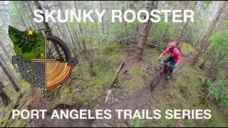
trail: Skunky Rooster
4:12 |
23 |
May 26, 2026 , Port Angeles
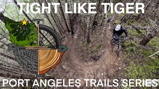
trail: Tight Like Tiger
3:30 |
17 |
May 26, 2026 , Port Angeles

trail: Water Buff Flow
2:42 |
15 |
May 26, 2026 , Port Angeles
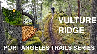
trail: Vulture Ridge
5:02 |
13 |
May 26, 2026 , Port Angeles
youtuber
![Vulture Ridge || Best Rock Work in Washington!]()
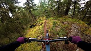
trail: Vulture Ridge
9:36 |
68 |
Apr 27, 2026 , Port Angeles
Recent Trail Reports
| status | trail | date | condition | info | user |
|---|---|---|---|---|---|
| Flutterby | Jun 16, 2026 @ 9:49pm (America/Los_Angeles) 2 days | Ideal | tdeems | ||
| Horse | Jun 12, 2026 @ 6:31pm (America/Los_Angeles) Jun 12, 2026 | Ideal | tdeems | ||
| Water Buff Flow | Jun 2, 2026 @ 7:19pm (America/Los_Angeles) Jun 2, 2026 | Ideal | kdenton911 | ||
| Gnaardvark | Jun 1, 2026 @ 5:33pm (America/Los_Angeles) Jun 1, 2026 | Dry | stephencanale TLTC | ||
| Sendtaur | May 21, 2026 @ 2:36pm (America/Los_Angeles) May 21, 2026 | Ideal | Gagevi | ||
| Salalamander | May 2, 2026 @ 11:32am (America/Vancouver) May 2, 2026 | Ideal | daoloth | ||
| Northside Access | May 2, 2026 @ 11:32am (America/Vancouver) May 2, 2026 | Ideal | daoloth | ||
| Dan Kelly Road | May 2, 2026 @ 11:32am (America/Vancouver) May 2, 2026 | Ideal | daoloth | ||
| Raw Frog | Apr 25, 2026 @ 3:55pm (America/Los_Angeles) Apr 25, 2026 | Ideal | StepanOnTheTrail | ||
| Beaver Moon | Apr 19, 2026 @ 2:58pm (America/Los_Angeles) Apr 19, 2026 | Unknown | chrisniclas |
Activity Feed
| username | action | type | title | date |
|---|---|---|---|---|
| tdeems | add | report | activity #97162280 | Jun 16, 2026 @ 9:49pm 2 days |
| DeckTwoNine | ridden | trail | activity #97133034 and 2 more | Jun 16, 2026 @ 12:57pm 3 days |
| roman777xxx | wishlist | trail | activity #97028968 | Jun 15, 2026 @ 2:19am Jun 15, 2026 |
| tdeems | add | report | activity #96841648 | Jun 12, 2026 @ 6:31pm Jun 12, 2026 |
| cjsurrusco | vote | trail | activity #96779175 | Jun 11, 2026 @ 7:30pm Jun 11, 2026 |
Recent Comments
| username | type | title | comment | date |
|---|---|---|---|---|
| trail | Trail is running fast and super fun. But you... | Jun 2, 2026 @ 7:17pm Jun 2, 2026 | ||
| trail | Amazing trail! Would consider this a tech... | May 12, 2026 @ 1:55am May 12, 2026 | ||
| trail | Second time heading up to Kelly Peak. The... | May 9, 2026 @ 12:58am May 9, 2026 | ||
| trail | The “step down” is a log drop. Go fast... | May 6, 2026 @ 4:02pm May 6, 2026 | ||
| trail | Gap jump in the middle has gotten bigger. Hit... | May 2, 2026 @ 1:32pm May 2, 2026 |
Nearby Areas
| name | distance | ||||
|---|---|---|---|---|---|
| Colville Trails | 7 | 2 | 1.8 km | ||
| Dry Hill | 10 | 49 | 24 | 8 | 4.2 km |
| Olympic Discovery | 7 | 5 km | |||
| Striped Peak | 5 | 3 | 5.2 km | ||
| Foothills | 15 | 7 | 4 | 6.9 km |
Local Badges
-

Completionist1 awarded
Local Products
Activity Type Stats
| activitytype | trails | distance | descent | descent distance | total vertical | rating | global rank | state rank | photos | reports | routes | ridelogs |
|---|---|---|---|---|---|---|---|---|---|---|---|---|
| Mountain Bike | 65 | 16 miles | 7,785 ft | 9 miles | 1,549 ft | #2,476 | #858 | 160 | 282 | 2,289 | ||
| E-Bike | 24 | #8,204 | #2,540 | 114 | 181 | |||||||
| Hike | 39 | 5 miles | 459 ft | 4,370 ft | 1,273 ft | #11,233 | #4,508 | 143 | 41 | |||
| Trail Running | 41 | 5 miles | 459 ft | 4,370 ft | 1,273 ft | #10,013 | #3,684 | 143 | 82 | |||
| Dirtbike/Moto | 14 | #1,027 | #472 | 4 | 2 |
Frequently Asked Questions About The Zoo
▼
What are the highest rated mountain biking trails in The Zoo?
The highest rated mountain biking trails in The Zoo are:
- Horse (4.5/5)
- Sound Bike and Yak (4.4/5)
- Vulture Ridge (4.3/5)
- Water Buff Flow (4.3/5)
- Flutterby (4.3/5)
▼
What is the best time of the year to ride in The Zoo?
Based on ride log data, the most popular months to ride in The Zoo are:
- July (29 activities)
- August (28 activities)
- May (15 activities)
▼
Where can I park to ride in The Zoo?
There are 1 parking locations listed in The Zoo. The most popular parking spots are:
▼
What is the longest trail in The Zoo?
The longest trail in The Zoo is Horse at 1.1 miles. View all trails sorted by distance.
Activities
Trails
Points of Interest
- By stephencanale
 TLTC & contributors
 - Admins: TLTC, TLTC
- #27955 - 12,616 views
- the zoo activity log | embed map of The Zoo mountain bike trails | the zoo mountain biking points of interest
Downloading of trail gps tracks in kml & gpx formats is enabled for The Zoo.
You must login to download files.