close
-
Layers w
- Weather Layers
- Pro
- Pro
- Pro
- Pro
- Pro
- Pro
- More Layers
- Pro
- Pro
- Pro
- Pro
-
Upgrade to

3D
Trail Conditions
- Unknown
- Snow Groomed
- Snow Packed
- Snow Covered
- Snow Cover Partial
- Freeze/thaw Cycle
- Icy
- Prevalent Mud
- Wet
- Variable
- Ideal
- Dry
- Very Dry
Trail Flow (Ridden Direction)
Trailforks scans users ridelogs to determine the most popular direction each trail is ridden. A good flowing trail network will have most trails flowing in a single direction according to their intension.
The colour categories are based on what percentage of riders are riding a trail in its intended direction.
The colour categories are based on what percentage of riders are riding a trail in its intended direction.
- > 96%
- > 90%
- > 80%
- > 70%
- > 50%
- < 50%
- bi-directional trail
- no data
Trail Last Ridden
Trailforks scans ridelogs to determine the last time a trail was ridden.
- < 2 days
- < 1 week
- < 2 weeks
- < 1 month
- < 6 months
- > 6 months
Trail Ridden Direction
The intended direction a trail should be ridden.
- Downhill Only
- Downhill Primary
- Both Directions
- Uphill Primary
- Uphill Only
- One Direction
Contribute Details
Colors indicate trail is missing specified detail.
- Description
- Photos
- Description & Photos
- Videos
Trail Popularity ?
Trailforks scans ridelogs to determine which trails are ridden the most in the last 9 months.
Trails are compared with nearby trails in the same city region with a possible 25 colour shades.
Think of this as a heatmap, more rides = more kinetic energy = warmer colors.
- most popular
- popular
- less popular
- not popular
ATV/ORV/OHV Filter
Max Vehicle Width
inches
US Cell Coverage
Legend

Radar Time
Activity Recordings
Trailforks uses anonymized public activity data.
?
Activity Recordings
Trailforks uses anonymized public activity data.
?
Personal Heatmap
▶
Activity Types
all
/
none
▶
Options
2
Date range
month
–
Winter Trails
Warning
A routing network for winter maps does not exist. Selecting trails using the winter trails layer has been disabled.
Missing Trails
Most Popular
Least Popular
Trails are colored based on popularity. The more popular a trail is, the more red. Less popular trails trend towards green.
Jump Magnitude Heatmap
Heatmap of where riders jump on trails. Zoom in to see individual jumps, click circles to view jump details.
BC Backroad Status
![map legend]()
Service Road Atlas is a free to use, community-driven service for viewing and creating reports on the numerous back-country service roads around B.C. and Alberta.

Slope Aspect
Direction the slope faces
Trails Deemphasized
Trails are shown in grey.
Only show trails with no bike usage.
Suggested Layers
Based on selected activity type
Save the current map location and zoom level as your default home location whenever this page is loaded.
SaveThe Zuni Mountains offer 50+ miles of singletrack across moderate terrain among Ponderosa forests and rolling mountains. Access is easy, with a couple of trailheads about 10 miles south of Interstate 40. There are two campgrounds and plenty of dispersed camping nearby.
The best riding is had from April to November but the winter months offer cross-country skiing, snow showing and fat biking depending on snow depths. In addition to singetrack options, there are also hundreds of miles of rugged forest two-track that offer the opportunity to explore some beautiful and remote areas. Bikepacking options abound but water isnt always easy to find in the dry months.
The best riding is had from April to November but the winter months offer cross-country skiing, snow showing and fat biking depending on snow depths. In addition to singetrack options, there are also hundreds of miles of rugged forest two-track that offer the opportunity to explore some beautiful and remote areas. Bikepacking options abound but water isnt always easy to find in the dry months.
Primary Trail Type: Cross-Country
Land Status: National Forest
 google parking directions
Links
Activities Click to view
- Mountain Bike
35 trails
- Horse
26 trails
- Hike
46 trails
- Trail Running
46 trails
- Snowshoe
1 trails
- Nordic Ski
1 trails
Region Details
- 6
- 4
- 28
- 2
Region Status
Open as of Jun 8, 2026Local Trail Association
Stats
- Avg Trail Rating
- Trails (view details)
- 46
- Trails Mountain Bike
- 35
- Trails E-Bike
- 3
- Trails Horse
- 26
- Trails Hike
- 46
- Trails Trail Running
- 46
- Trails Dirtbike/Moto
- 3
- Trails ATV/ORV/OHV
- 3
- Trails Snowshoe
- 1
- Trails Nordic Ski
- 1
- Total Distance
- 131 miles
- Total Descent
- 11,863 ft
- Total Vertical
- 1,754 ft
- Highest Trailhead
- 8,656 ft
- Reports
- 331
- Photos
- 96
- Ridden Counter
- 2,983
Popular Zuni Mountains Mountain Biking Trails
• 65 ★ 4.0 • 5 miles • 255 ft • 268 •
Moderately popular blue difficulty singletrack. This multi-use trail. On average it takes 29 minutes to complete this trail.
• 85 ★ 4.0 • 3 miles • 547 ft • 222 •
Starting from the Hilso Trailhead, the trail gradually climbs through a drainage to end up at Sheetrock Tank. It starts out pretty easy and sometimes there are a number of hikers, but it soon enters the trees, including a small aspen...
• 100 ★ 0.0 • 2 miles • 126 ft • 220 •
The splits from the and connects to the Canyon Trail. It is a gentle grade with a few rocky sections but it is a moderate route.
• 100 ★ 4.0 • 5 miles • 382 ft • 197 •
Popular green difficulty singletrack. This multi-use trail can be used both directions and has a easy overall physical rating with a 382 ft green climb. On average it takes 35 minutes to complete this trail.
• 70 ★ 3.8 • 3 miles • 338 ft • 197 •
Popular blue difficulty singletrack. This multi-use trail can be used both directions and has a moderate overall physical rating with a 338 ft blue climb. On average it takes 25 minutes to complete this trail.
• 100 ★ 4.0 • 1 mile • 127 ft • 166 •
Popular blue difficulty singletrack. This multi-use trail can be used both directions and has a moderate overall physical rating with a 127 ft blue climb. Trail visibility is always easy to follow. On average it takes 13 minutes to complete this trail.
• 60 ★ 3.0 • 2 miles • 199 ft • 119 •
Smokin' Handlebar is moderate, rolling trail with a few punchy climbs and rock gardens to keep it interesting. As you parallel the fence line at the top, you are right next to the Ft. Wingate Military Depot.
Zuni Mountains Mountain Bike Routes
★ 5.0 • 49 miles • 4,075 ft • 10 •
This is linking up ~50 miles in the Zuni's for a NMES group ride.
16 miles • 1,383 ft • 5 • Loop •
This loop takes in some of the more technical trails in the area while not being too hard. It starts with...
26 miles • 2,075 ft • 7 • Loop •
This loop is a great option for a sub 30-miler that is challenging and fun. The long descent down and is...
9 miles • 827 ft • 4 • Loop •
This is the classic way to ride the Strawberry, Tampico and Mikes Rippin trails and is great for a quick...
21 miles • 1,520 ft • 3 • Shuttled •
The McKenzie/ Epic is a 21-mile shuttle route showcasing some of the most challenging and rewarding riding...
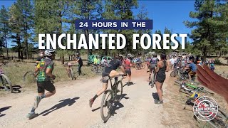
★ 1.0 • 15 miles • 1,034 ft • 4 •
New course for the 2025 Zia Rides 24-hours in the Enchanted Forest.
Photos of Zuni Mountains Mountain Bike
Videos of Zuni Mountains Mountain Bike
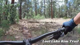
trail: Lost Lake Rim Trail
45:03 |
100 |
Jul 9, 2025 , Gallup
trail: Quaking Aspen
17:42 |
273 |
Jun 18, 2021 , Gallup

trail: Smokin' Handelbar
17:42 |
234 |
Jun 18, 2021 , Gallup

trail: Y2K
17:42 |
489 |
Jun 18, 2021 , Gallup
Recent Trail Reports
| status | trail | date | condition | info | user |
|---|---|---|---|---|---|
| Milk Ranch Canyon | Jun 8, 2026 @ 8:09pm (America/Denver) Jun 8, 2026 | Dry | MichaelDeMattiesYgx | ||
| McKenzie Ridge East | May 24, 2026 @ 8:58pm (America/Denver) May 24, 2026 | Dry | CheapThrills GALLUP | ||
| Berma Rd. | May 11, 2026 @ 10:44am (America/Denver) May 11, 2026 | Unknown | flappjack99 | ||
| Milk Ranch Canyon Connector | Apr 17, 2026 @ 8:30am (America/Denver) Apr 17, 2026 | Ideal | CheapThrills GALLUP | ||
| Y2K | Apr 3, 2026 @ 8:15pm (America/Denver) Apr 3, 2026 | Unknown | CheapThrills GALLUP | ||
| Lost Lake Rim Trail | Apr 3, 2026 @ 2:18pm (America/Denver) Apr 3, 2026 | Unknown | CheapThrills GALLUP | ||
| Tampico Springs | Mar 12, 2026 @ 4:12pm (America/Denver) Mar 12, 2026 | Unknown | CheapThrills GALLUP | ||
| Torreon | Mar 12, 2026 @ 4:12pm (America/Denver) Mar 12, 2026 | Unknown | CheapThrills GALLUP | ||
| Strawberry Canyon | Mar 12, 2026 @ 4:12pm (America/Denver) Mar 12, 2026 | Unknown | CheapThrills GALLUP | ||
| Mike's Rippin | Mar 12, 2026 @ 4:12pm (America/Denver) Mar 12, 2026 | Unknown | CheapThrills GALLUP |
Activity Feed
| username | action | type | title | date |
|---|---|---|---|---|
| LlNyijQ8 | wishlist | trail | activity #96806264 | Jun 12, 2026 @ 8:28am Jun 12, 2026 |
| MichaelDeMattiesYgx | add | report | activity #96579996 | Jun 8, 2026 @ 7:09pm Jun 8, 2026 |
| MichaelDeMattiesYgx | comment | trail | activity #96578594 | Jun 8, 2026 @ 6:36pm Jun 8, 2026 |
| CheapThrills | add | photo | activity #95661725 | May 27, 2026 @ 2:34pm May 27, 2026 |
| CheapThrills | add | poi | activity #95661722 | May 27, 2026 @ 2:34pm May 27, 2026 |
Recent Comments
| username | type | title | comment | date |
|---|---|---|---|---|
| trail | Totally agree with last comment. Dope trail.... | Jun 8, 2026 @ 6:36pm Jun 8, 2026 | ||
| report | Thanks for the feedback and completely agree;... | May 13, 2026 @ 6:50am May 13, 2026 | ||
| trail | Trail is incredibly rough and harsh. Tread is... | Apr 18, 2026 @ 10:12pm Apr 18, 2026 | ||
| report | Had a storm 2 weeks ago, so it's definitely... | Feb 5, 2026 @ 1:37pm Feb 5, 2026 | ||
| report | Would you say it’s still worth riding now?... | Feb 5, 2026 @ 8:17am Feb 5, 2026 |
Nearby Areas
| name | distance | ||||
|---|---|---|---|---|---|
| Red Rock Park | 9.9 km | ||||
| Rehoboth Community Trails | 7 | 2 | 2 | 10 km | |
| Brickyard Bike Park | 9 | 3 | 1 | 13.4 km | |
| Twin Springs | 1 | 8 | 14.4 km | ||
| High Desert Trails | 3 | 6 | 18.7 km |
Local Badges
-

Completionist0 awarded
Activity Type Stats
| activitytype | trails | distance | descent | descent distance | total vertical | rating | global rank | state rank | photos | reports | routes | ridelogs |
|---|---|---|---|---|---|---|---|---|---|---|---|---|
| Mountain Bike | 35 | 110 miles | 8,888 ft | 39 miles | 1,752 ft | #2,552 | #888 | 101 | 329 | 13 | 2,678 | |
| E-Bike | 3 | 24 miles | 1,089 ft | 6 miles | 1,591 ft | 251 | 19 | |||||
| Horse | 26 | 94 miles | 6,952 ft | 31 miles | 1,719 ft | #606 | #324 | 50 | ||||
| Hike | 46 | 131 miles | 11,864 ft | 51 miles | 1,752 ft | #1,671 | #738 | 329 | 1 | 48 | ||
| Trail Running | 46 | 131 miles | 11,864 ft | 51 miles | 1,752 ft | #1,034 | #327 | 329 | 4 | |||
| Dirtbike/Moto | 3 | 24 miles | 1,089 ft | 6 miles | 1,591 ft | 18 | ||||||
| ATV/ORV/OHV | 3 | 24 miles | 1,089 ft | 6 miles | 1,591 ft | 18 | 2 | |||||
| Snowshoe | 1 | 2 miles | 230 ft | 4,672 ft | 151 ft | #2,105 | #1,175 | 2 | ||||
| Nordic Ski | 1 | 2 miles | 230 ft | 4,672 ft | 151 ft | #2,017 | #1,037 | 2 | 1 |
Frequently Asked Questions About Zuni Mountains
▼
What are the highest rated mountain biking trails in Zuni Mountains?
The highest rated mountain biking trails in Zuni Mountains are:
- Milk Ranch Canyon (4.3/5)
- Mike's Rippin (4.1/5)
- Strawberry Canyon (4.1/5)
- Quaking Aspen (4/5)
- Plush (4/5)
▼
What is the best time of the year to ride in Zuni Mountains?
Based on ride log data, the most popular months to ride in Zuni Mountains are:
- June (45 activities)
- September (30 activities)
- May (27 activities)
▼
Where can I park to ride in Zuni Mountains?
There are 2 parking locations listed in Zuni Mountains. The most popular parking spots are:
▼
What is the longest trail in Zuni Mountains?
The longest trail in Zuni Mountains is McKenzie Ridge at 13.6 miles. View all trails sorted by distance.
Activities
Trails
- By bsieb & contributors
- Admins: GALLUP
- #9232 - 9,697 views
- zuni mountains activity log | embed map of Zuni Mountains mountain bike trails | zuni mountains mountain biking points of interest
Downloading of trail gps tracks in kml & gpx formats is enabled for Zuni Mountains.
You must login to download files.