close
-
Layers w
- Weather Layers
- Pro
- Pro
- Pro
- Pro
- Pro
- Pro
- More Layers
- Pro
- Pro
- Pro
- Pro
-
Upgrade to

3D
Trail Conditions
- Unknown
- Snow Groomed
- Snow Packed
- Snow Covered
- Snow Cover Partial
- Freeze/thaw Cycle
- Icy
- Prevalent Mud
- Wet
- Variable
- Ideal
- Dry
- Very Dry
Trail Flow (Ridden Direction)
Trailforks scans users ridelogs to determine the most popular direction each trail is ridden. A good flowing trail network will have most trails flowing in a single direction according to their intension.
The colour categories are based on what percentage of riders are riding a trail in its intended direction.
The colour categories are based on what percentage of riders are riding a trail in its intended direction.
- > 96%
- > 90%
- > 80%
- > 70%
- > 50%
- < 50%
- bi-directional trail
- no data
Trail Last Ridden
Trailforks scans ridelogs to determine the last time a trail was ridden.
- < 2 days
- < 1 week
- < 2 weeks
- < 1 month
- < 6 months
- > 6 months
Trail Ridden Direction
The intended direction a trail should be ridden.
- Downhill Only
- Downhill Primary
- Both Directions
- Uphill Primary
- Uphill Only
- One Direction
Contribute Details
Colors indicate trail is missing specified detail.
- Description
- Photos
- Description & Photos
- Videos
Trail Popularity ?
Trailforks scans ridelogs to determine which trails are ridden the most in the last 9 months.
Trails are compared with nearby trails in the same city region with a possible 25 colour shades.
Think of this as a heatmap, more rides = more kinetic energy = warmer colors.
- most popular
- popular
- less popular
- not popular
ATV/ORV/OHV Filter
Max Vehicle Width
inches
US Cell Coverage
Legend

Radar Time
Activity Recordings
Trailforks uses anonymized public activity data.
?
Activity Recordings
Trailforks uses anonymized public activity data.
?
Personal Heatmap
▶
Activity Types
all
/
none
▶
Options
2
Date range
month
–
Winter Trails
Warning
A routing network for winter maps does not exist. Selecting trails using the winter trails layer has been disabled.
Missing Trails
Most Popular
Least Popular
Trails are colored based on popularity. The more popular a trail is, the more red. Less popular trails trend towards green.
Jump Magnitude Heatmap
Heatmap of where riders jump on trails. Zoom in to see individual jumps, click circles to view jump details.
BC Backroad Status
![map legend]()
Service Road Atlas is a free to use, community-driven service for viewing and creating reports on the numerous back-country service roads around B.C. and Alberta.

Slope Aspect
Direction the slope faces
Trails Deemphasized
Trails are shown in grey.
Only show trails with no bike usage.
Suggested Layers
Based on selected activity type
Save the current map location and zoom level as your default home location whenever this page is loaded.
Save
No description for Zürich has been added yet!
Login or register to submit one.
This region uses the Uk/Euro style trail grading system.
Activities Click to view
- Mountain Bike
47 trails
- E-Bike
46 trails
- Gravel Bike
0 trails
- Adaptive Bike
0 trails
- Hike
53 trails
- Trail Running
53 trails
Region Details
- 6
- 17
- 16
- 6
- 1
Region Status
Open as of 11 hoursLocal Trail Association
Stats
- Avg Trail Rating
- Trails (view details)
- 63
- Trails Mountain Bike
- 47
- Trails E-Bike
- 46
- Trails Hike
- 53
- Trails Trail Running
- 53
- Total Distance
- 29 miles
- Total Descent
- 11,261 ft
- Total Vertical
- 1,465 ft
- Highest Trailhead
- 2,876 ft
- Reports
- 3,320
- Photos
- 451
- Ridden Counter
- 15,695
Sub Regions
-
Buechhoger - Altholz
- 1
-
Uetliberg
- 7
- 8
- 4
- 1
-
Züriberg
- 4
- 6
- 1
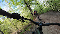
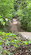
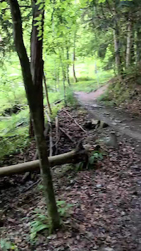
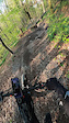
Popular Zürich Mountain Biking Trails
• 100 ★ 4.1 • 2 miles • 53 ft • 1,050 •
Highly rated popular red difficulty machine groomed. This mountain bike primary trail and has a moderate overall physical rating. It features berm, jump and wallride. On average it takes 15 minutes to complete this trail.
• 90 ★ 4.3 • 1 mile • 3 ft • 617 •
Der Höcklertrail fackelt nicht lange: Gleich im ersten Abschnitt nimmst du Speed auf und fliegst über die ersten Jumps und steuerst auf das erste Highlight zu – den Giacomo-Drop (keine Sorge, für Vorsichtige gibt es eine...
• 95 ★ 3.4 • 1 mile • 0 ft • 578 •
Einsteigerfreundlicher Biketrail im Norden von Zürich. Ein paar kleinere Sprünge sorgen für zusätzlichen Spass.
• 90 ★ 3.1 • 2,182 ft • 24 ft • 504 •
The Grattrail let's you ride on singletrack instead of the (busy) road. It can be ridden in both ways, so please watch out. Those in the uphill have the right of way.
• 95 ★ 4.3 • 3,179 ft • 6 ft • 488 •
skills track for beginners, starts easy but speeds up with jumps in the second section. good flow
• 90 ★ 3.8 • 1,729 ft • 0 ft • 434 •
Lower Part of the Adlisbergtrail with a couple of narrow turns. Avoid after rain, as it gets full of horrible mud that blocks your tires
• 85 ★ 1.3 • 709 ft • 0 ft • 431 •
Popular green difficulty family friendly singletrack. This multi-use trail can be used both directions and has a easy overall physical rating with a 0 ft green climb. Trail visibility is always easy to follow. On average it takes minutes to complete this trail.
• 85 ★ 3.9 • 3,153 ft • 13 ft • 274 •
Nice trail from the summit of Zürichberg. Beginning is rather flat, after while you reach the pumptrack where you can practice your skills. There is a jumpline as well. The trail continues at the end of the park with a steep U, some...
Zürich Mountain Bike Routes
11 miles • 2,758 ft • 7 • Loop •
This Route includes all official bike trails by Zürtrails at Üetliberg. You can start also from side.
2 miles • 156 ft • 0 • Loop •
Der Campus in der Brunau, am Fusse des Uetlibergs, ist der Ausgangspunkt der Teststrecken für Rennvelos,...
8 miles • 999 ft • 0 •
Photos of Zürich Mountain Bike
Videos of Zürich Mountain Bike
trail: Alt Uetliberg
0:38 |
10 |
May 1, 2026
0:09 |
12 |
Apr 28, 2026
0:02 |
5 |
May 27, 2025
trail: Antennentrail
0:27 |
110 |
May 4, 2023

trail: Höcklertrail by Züritrails
7:24 |
162 |
Nov 7, 2021
trail: Antennentrail
9:54 |
132 |
Nov 7, 2021
trail: Allmendtrail
2:38 |
671 |
May 17, 2021
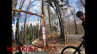
trail: Höcklertrail by Züritrails
6:03 |
1242 |
May 1, 2021
Recent Trail Reports
| status | trail | date | condition | info | user |
|---|---|---|---|---|---|
| Biketrail Adlisberg | Jun 21, 2026 @ 7:17pm (Europe/Zurich) 11 hours | Ideal | tfritz80 | ||
| Antennentrail | Jun 20, 2026 @ 10:54am (Europe/Zurich) 2 days | Unknown | disli | ||
| No Horses Allowed | Jun 14, 2026 @ 8:30am (Europe/Zurich) Jun 13, 2026 | Ideal | queenieman | ||
| Zürichberg Pumptrack-Trail | Jun 14, 2026 @ 8:30am (Europe/Zurich) Jun 13, 2026 | Ideal | queenieman | ||
| Biketrail Adlisberg Rot | Jun 14, 2026 @ 8:30am (Europe/Zurich) Jun 13, 2026 | Ideal | queenieman | ||
| Höcklertrail by Züritrails | Jun 13, 2026 @ 8:57pm (Europe/Zurich) Jun 13, 2026 | Unknown | svenbusam | ||
| Allmendtrail | Jun 8, 2026 @ 1:56pm (Europe/Zurich) Jun 8, 2026 | Ideal | blaze-j | ||
| Playground Ridge | Jun 8, 2026 @ 1:56pm (Europe/Zurich) Jun 8, 2026 | Ideal | blaze-j | ||
| Playground Ridge Dropin | Jun 8, 2026 @ 1:56pm (Europe/Zurich) Jun 8, 2026 | Ideal | blaze-j | ||
| Uetliberg Uphill | Jun 8, 2026 @ 1:56pm (Europe/Zurich) Jun 8, 2026 | Dry | blaze-j |
Activity Feed
| username | action | type | title | date |
|---|---|---|---|---|
| tfritz80 | add | report | activity #97498012 | Jun 21, 2026 @ 10:17am 11 hours |
| disli | add | report | activity #97373366 | Jun 20, 2026 @ 1:54am 2 days |
| JuliusSgMeYk | wishlist | route | activity #97341517 | Jun 19, 2026 @ 1:33pm 2 days |
| JuliusSgMeYk | comment | trail | activity #97341452 | Jun 19, 2026 @ 1:32pm 2 days |
| JuliusSgMeYk | wishlist | trail | activity #97340212 | Jun 19, 2026 @ 1:10pm 2 days |
Recent Comments
| username | type | title | comment | date |
|---|---|---|---|---|
| trail | 19.6.26 Nach dem Unwetter am Abend hat der... | Jun 19, 2026 @ 1:32pm 2 days | ||
| report | 👍 | Apr 29, 2026 @ 11:00am Apr 29, 2026 | ||
| trail | Easy flow trail, fairly slow, divided into... | Mar 8, 2026 @ 6:21am Mar 8, 2026 | ||
| trail | Aktuell gesperrt! | Jan 24, 2026 @ 5:43am Jan 24, 2026 | ||
| report | Will be fixed at the Trailcare Day next... | Nov 16, 2025 @ 7:21am Nov 16, 2025 |
Local Badges
-

Top 10 Trails11 awarded -

Cycle Week 2025 Day 10 awarded -

Cycle Week 2025 Day 22 awarded -

Cycle Week 2025 Day 44 awarded -

Cycle Week 2025 Day 311 awarded -

10 Green Trails201 awarded
Bike & Skill Parks
| name | type | city | rating |
|---|---|---|---|
| Züritrails Jumppark | skill park | Zürich | |
| NT Dirt Glattpark | skill park | Zürich | |
| Pump Track Züriberg | skill park | Zürich | |
| Bikepark Zürich | skill park | Zürich | |
| Pumptrack Opfikon | skill park | Zürich |
Local Mountain Biking Directory
-
velomaerkte.ch Zurich
-
Zurich Youth Hostel
![Zurich Youth Hostel]()
-
ZüritrailsTrail Association
![Züritrails]()
-
BiromaBike Shop
![Biroma]()
-
Bikehub ZurichBike Shop
![Bikehub Zurich]()
-
Bike Home ServiceBike Shop
Local Products
Activity Type Stats
| activitytype | trails | distance | descent | descent distance | total vertical | rating | global rank | state rank | photos | reports | routes | ridelogs |
|---|---|---|---|---|---|---|---|---|---|---|---|---|
| Mountain Bike | 47 | 21 miles | 8,333 ft | 15 miles | 1,427 ft | #814 | #6 | 447 | 3,318 | 4 | 58,398 | |
| E-Bike | 46 | 20 miles | 8,071 ft | 14 miles | 1,427 ft | #638 | #50 | 3 | 2,938 | 3 | 7,361 | |
| Hike | 53 | 21 miles | 7,087 ft | 11 miles | 1,463 ft | #673 | #15 | 2,470 | 1,597 | |||
| Trail Running | 53 | 21 miles | 7,087 ft | 11 miles | 1,463 ft | #966 | #24 | 2,470 | 3,352 |
Frequently Asked Questions About Zürich
▼
What are the best places to ride in Zürich?
Zürich has 3 areas to explore for mountain biking. The top rated areas are:
▼
What are the highest rated mountain biking trails in Zürich?
The highest rated mountain biking trails in Zürich are:
- Leiterlitrail (4.5/5)
- Playground Ridge (4.4/5)
- Home Office (4.3/5)
- Allmendtrail (4.2/5)
- Zuriberg Massacre (4.2/5)
▼
What is the best time of the year to ride in Zürich?
Based on ride log data, the most popular months to ride in Zürich are:
- July (171 activities)
- May (152 activities)
- August (135 activities)
▼
Where can I park to ride in Zürich?
Activities
Trails
- By ataraxus & contributors
- Admins: Züritrails, Zürich
- #4693 - 35,419 views
- zürich activity log | embed map of Zürich mountain bike trails | zürich mountain biking points of interest polygons
Downloading of trail gps tracks in kml & gpx formats is enabled for Zürich.
You must login to download files.