9.7 miles
Distance
1,264 ft
Climb
-1,258 ft
Descent
591 ft
High Point
6 ft
Altitude change
129 ft
Altitude min
425 ft
Altitude start
430 ft
Altitude end
-32.9%
Grade max
69%
Grade min
4 miles
Distance climb
4 miles
Distance down
1 mile
Distance flat

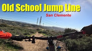
10 miler Intermediate Green/Blue

Detailed Description
10 miler Intermediate is a 10 mile moderately popular intermediate route located near San Clemente California. This mountain bike only route. This route includes 14 trails. This route climbs 1,264 ft with a max elevation of 591 ft then descends -1,258 ft.

Trail Issues on Route

  • Significant Issue / Amber: 1 trail (newest: Apr 6, 2026)
  • Minor Issue / Yellow: 2 trails (newest: May 30, 2025)
Local Trail Association
Local trail association
Laguna Canyon Riders
Please consider joining or donating to the local riding association to support trail development & maintenance.
Donate to earn trail karma!

Stats

  • Distance
    10 miles
  • Altitude change
    6 ft
  • Altitude min
    129 ft
  • Altitude start
    425 ft
  • Altitude end
    430 ft
  • Climb
    1,264 ft
  • Descent
    -1,258 ft
  • Grade max
    -32.9%
  • Grade min
    69%
  • Distance climb
    4 miles
  • Distance down
    4 miles
  • Distance flat
    1 mile

23 Reviews & Comments


We hope you've been enjoying Trailforks!

Create a FREE account to view route comments and much more.

Trails in Route

Holeshot4,938 ft
Upper Power Plant3,284 ft
Upper Butche's1 mile
Couches702 ft
Easy-up1,063 ft
Uppers1,759 ft
Beer Run505 ft
Jumpline 2522 ft
Upline433 ft
Jumpline 1433 ft
Dia2,480 ft
No Tools3,510 ft
Bottom's Up3,668 ft
Blue Chair1 mile

Details

  • Riding area
  • Primary Activity
    Mountain Bike
  • Difficulty rating
    Blue
no votes yet
close
3D
Trail Conditions
  • Unknown
  • Snow Groomed
  • Snow Packed
  • Snow Covered
  • Snow Cover Partial
  • Freeze/thaw Cycle
  • Icy
  • Prevalent Mud
  • Wet
  • Variable
  • Ideal
  • Dry
  • Very Dry
Trail Flow (Ridden Direction)
Trailforks scans users ridelogs to determine the most popular direction each trail is ridden. A good flowing trail network will have most trails flowing in a single direction according to their intension.
The colour categories are based on what percentage of riders are riding a trail in its intended direction.
  • > 96%
  • > 90%
  • > 80%
  • > 70%
  • > 50%
  • < 50%
  • bi-directional trail
  • no data
Trail Last Ridden
Trailforks scans ridelogs to determine the last time a trail was ridden.
  • < 2 days
  • < 1 week
  • < 2 weeks
  • < 1 month
  • < 6 months
  • > 6 months
Trail Ridden Direction
The intended direction a trail should be ridden.
  • Downhill Only
  • Downhill Primary
  • Both Directions
  • Uphill Primary
  • Uphill Only
  • One Direction
Contribute Details
Colors indicate trail is missing specified detail.
  • Description
  • Photos
  • Description & Photos
  • Videos
Trail Popularity ?
Trailforks scans ridelogs to determine which trails are ridden the most in the last 9 months. Trails are compared with nearby trails in the same city region with a possible 25 colour shades. Think of this as a heatmap, more rides = more kinetic energy = warmer colors.
  • most popular
  • popular
  • less popular
  • not popular
ATV/ORV/OHV Filter
Max Vehicle Width
inches
US Cell Coverage
Legend
cell carrier legend

Radar Time
Activity Recordings
Trailforks uses anonymized public activity data. ?
Activity Recordings
Trailforks uses anonymized public activity data. ?
Personal Heatmap
Activity Types
all / none
Options
2
Date range month
Winter Trails
Warning A routing network for winter maps does not exist. Selecting trails using the winter trails layer has been disabled.
Missing Trails
Most Popular
Least Popular
Trails are colored based on popularity. The more popular a trail is, the more red. Less popular trails trend towards green.
Jump Magnitude Heatmap
Heatmap of where riders jump on trails. Zoom in to see individual jumps, click circles to view jump details.
BC Backroad Status

Service Road Atlas is a free to use, community-driven service for viewing and creating reports on the numerous back-country service roads around B.C. and Alberta.

map legend
Slope Aspect
Direction the slope faces
Flat N NE E SE S SW W NW
Trails Deemphasized
Trails are shown in grey.
disable
Only show trails with no bike usage.
Enable
Suggested Layers
Based on selected activity type

    Save the current map location and zoom level as your default home location whenever this page is loaded.

    Save
    Trail transparency
    • Singletrack
    158
    130
    184
    148
    youtuber Frank n Beans Dia San Clemente Jumpline Trail...
    Frank n Beans Dia San Clemente Jumpline Trail 2025 2026
    trail: Dia
    5:19 | 78 | comments: 0 | favs:
    Jan 3, 2026
    trail: Beer Run
    0:13 | 5 | comments: 0 | favs:
    May 25, 2026

    Recent Trail Reports Along Route

    statustraildateconditiondescription
    Holeshot
    May 12, 2026 @ 4:19pm (America/Los_Angeles)
    May 12, 2026
    clear
    Upper Butche's
    Apr 6, 2026 @ 5:55pm (America/Los_Angeles)
    Apr 6, 2026
    Some parts are very overgrown esp. the southern end before it connects to Holeshot.
    Dia
    Mar 4, 2026 @ 4:14pm (America/Los_Angeles)
    Mar 4, 2026
    Couches
    Nov 30, 2025 @ 7:37am (America/Los_Angeles)
    Nov 30, 2025
    Blue Chair
    May 30, 2025 @ 10:46pm
    May 30, 2025
    Dry and overgrown vegetation. Recommend wearing long sleeves and gloves
    more reports »
    • By ppch & contributors
    • #54202 - 893 views

    Hit the Trail

    Open in App

    Get this route on your phone instantly.

    Download Route

    Save to wishlist, Garmin & download.