3.0 miles
Distance
385 ft
Climb
-385 ft
Descent
4,807 ft
High Point
4,563 ft
Altitude min
4,563 ft
Altitude start
4,564 ft
Altitude end
-32.3%
Grade max
27%
Grade min
1 mile
Distance climb
1 mile
Distance down
2,215 ft
Distance flat

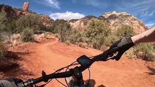
Want some technical riding but don't want to be out for too long? This short loop will pack in rock armoring and rock gardens, techy climbs, traversing, and descending. You can also ride this either direction - do both and see which way you like better Start at the Teacup Trailhead on the south side of Sugar Loaf. Begin climbing up Teacup towards its intersection with Thunder Mountain. Hang a left and continue west. At the intersection of Andante and Thunder Mountain, make your choice and continue on. Andante is a smoother pedal across the base of Thunder Mountain, whereas Thunder Mountain Trail will climb to a high point and descend no matter which direction you decide to take. Return to Teacup and back to the parking lot.

Detailed Description
Adobe Jack 5 is a 3 mile moderately popular expert route located near Sedona Arizona. This mountain bike primary route. This route includes 5 trails. This route climbs 385 ft with a max elevation of 4,807 ft then descends -385 ft.
Local Trail Association
Please consider joining or donating to the local riding association to support trail development & maintenance.
Donate to earn trail karma!

Stats

  • Distance
    3 miles
  • Avg time
    50 min 47 sec
  • Altitude min
    4,563 ft
  • Altitude start
    4,563 ft
  • Altitude end
    4,564 ft
  • Climb
    385 ft
  • Descent
    -385 ft
  • Grade max
    -32.3%
  • Grade min
    27%
  • Distance climb
    1 mile
  • Distance down
    1 mile
  • Distance flat
    2,215 ft

13 Reviews & Comments


We hope you've been enjoying Trailforks!

Create a FREE account to view route comments and much more.

Trails in Route

Teacup1,749 ft
Thunder Mountain1,155 ft
Andante3,750 ft
Thunder Mountain1 mile
Teacup1,749 ft

Details

  • Riding area
  • Primary Activity
    Mountain Bike
  • Other Activities
    • Hike
    • Trail Running
  • Difficulty rating
    Black Diamond
  • Route Type
    Loop
  • eBike Allowed
  • Bike type
    AM, XC
  • Ridelogs
    32
no votes yet
close
3D
Trail Conditions
  • Unknown
  • Snow Groomed
  • Snow Packed
  • Snow Covered
  • Snow Cover Partial
  • Freeze/thaw Cycle
  • Icy
  • Prevalent Mud
  • Wet
  • Variable
  • Ideal
  • Dry
  • Very Dry
Trail Flow (Ridden Direction)
Trailforks scans users ridelogs to determine the most popular direction each trail is ridden. A good flowing trail network will have most trails flowing in a single direction according to their intension.
The colour categories are based on what percentage of riders are riding a trail in its intended direction.
  • > 96%
  • > 90%
  • > 80%
  • > 70%
  • > 50%
  • < 50%
  • bi-directional trail
  • no data
Trail Last Ridden
Trailforks scans ridelogs to determine the last time a trail was ridden.
  • < 2 days
  • < 1 week
  • < 2 weeks
  • < 1 month
  • < 6 months
  • > 6 months
Trail Ridden Direction
The intended direction a trail should be ridden.
  • Downhill Only
  • Downhill Primary
  • Both Directions
  • Uphill Primary
  • Uphill Only
  • One Direction
Contribute Details
Colors indicate trail is missing specified detail.
  • Description
  • Photos
  • Description & Photos
  • Videos
Trail Popularity ?
Trailforks scans ridelogs to determine which trails are ridden the most in the last 9 months. Trails are compared with nearby trails in the same city region with a possible 25 colour shades. Think of this as a heatmap, more rides = more kinetic energy = warmer colors.
  • most popular
  • popular
  • less popular
  • not popular
ATV/ORV/OHV Filter
Max Vehicle Width
inches
US Cell Coverage
Legend
cell carrier legend

Radar Time
Activity Recordings
Trailforks uses anonymized public activity data. ?
Activity Recordings
Trailforks uses anonymized public activity data. ?
Personal Heatmap
Activity Types
all / none
Options
2
Date range month
Winter Trails
Warning A routing network for winter maps does not exist. Selecting trails using the winter trails layer has been disabled.
Missing Trails
Most Popular
Least Popular
Trails are colored based on popularity. The more popular a trail is, the more red. Less popular trails trend towards green.
Jump Magnitude Heatmap
Heatmap of where riders jump on trails. Zoom in to see individual jumps, click circles to view jump details.
BC Backroad Status

Service Road Atlas is a free to use, community-driven service for viewing and creating reports on the numerous back-country service roads around B.C. and Alberta.

map legend
Slope Aspect
Direction the slope faces
Flat N NE E SE S SW W NW
Trails Deemphasized
Trails are shown in grey.
disable
Only show trails with no bike usage.
Enable
Suggested Layers
Based on selected activity type

    Save the current map location and zoom level as your default home location whenever this page is loaded.

    Save
    Trail transparency
    • Singletrack
    356
    426
    399
    543
    Sedona MTB - Thunder Mountain Trail
    Sedona MTB - Thunder Mountain Trail
    18:28 | 123 | comments: 0 | favs:
    Feb 14, 2025
    Sedona MTB - Teacup Trail
    Sedona MTB - Teacup Trail
    trail: Teacup
    11:11 | 138 | comments: 0 | favs:
    Feb 14, 2025

    Recent Trail Reports Along Route

    statustraildateconditiondescription
    Andante
    Apr 19, 2026 @ 10:58am (America/Phoenix)
    Apr 19, 2026
    Teacup
    Feb 1, 2026 @ 9:46am (America/Phoenix)
    Feb 1, 2026
    more reports »
    • By MollyJoyceTF Pro & contributors
    • #17760 - 837 views

    Hit the Trail

    Open in App

    Get this route on your phone instantly.

    Download Route

    Save to wishlist, Garmin & download.