7.3 miles
Distance
2,096 ft
Climb
-2,097 ft
Descent
2 miles
High Point
0 ft
Altitude change
8,608 ft
Altitude min
8,681 ft
Altitude start
8,681 ft
Altitude end
-50.5%
Grade max
62.8%
Grade min
4 miles
Distance climb
3 miles
Distance down
1,017 ft
Distance flat

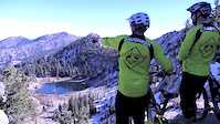
Biking loop in from Albion Basin up to Devil's Castle, Supreme, and then back down to the start.

Detailed Description
Altaworld is a 7 mile moderately popular expert route located near Alta Utah. This mountain bike primary route can be used both directions. This route includes 6 trails. This route climbs 2,096 ft with a max elevation of 10,476 ft then descends -2,097 ft.

Trail Issues on Route

  • Closed: 1 trail (newest: Aug 4, 2025)
  • Significant Issue / Amber: 2 trails (newest: Jun 4, 2026)
Local Trail Association
Please consider joining or donating to the local riding association to support trail development & maintenance.
Donate to earn trail karma!

Stats

  • Distance
    7 miles
  • Avg time
    3 hr 1 min
  • Altitude min
    8,608 ft
  • Altitude start
    8,681 ft
  • Altitude end
    8,681 ft
  • Climb
    2,096 ft
  • Descent
    -2,097 ft
  • Grade max
    -50.5%
  • Grade min
    62.8%
  • Distance climb
    4 miles
  • Distance down
    3 miles
  • Distance flat
    1,017 ft

19 Reviews & Comments


We hope you've been enjoying Trailforks!

Create a FREE account to view route comments and much more.

Details

  • Riding area
  • Primary Activity
    Mountain Bike
  • Other Activities
    • E-Bike
    • Hike
    • Trail Running
  • Difficulty rating
    Black Diamond
  • Route Type
    Loop
  • eBike Allowed
  • Bike type
    AM, XC
  • Direction
    Both Directions
  • Ridelogs
    1
no votes yet
close
3D
Trail Conditions
  • Unknown
  • Snow Groomed
  • Snow Packed
  • Snow Covered
  • Snow Cover Partial
  • Freeze/thaw Cycle
  • Icy
  • Prevalent Mud
  • Wet
  • Variable
  • Ideal
  • Dry
  • Very Dry
Trail Flow (Ridden Direction)
Trailforks scans users ridelogs to determine the most popular direction each trail is ridden. A good flowing trail network will have most trails flowing in a single direction according to their intension.
The colour categories are based on what percentage of riders are riding a trail in its intended direction.
  • > 96%
  • > 90%
  • > 80%
  • > 70%
  • > 50%
  • < 50%
  • bi-directional trail
  • no data
Trail Last Ridden
Trailforks scans ridelogs to determine the last time a trail was ridden.
  • < 2 days
  • < 1 week
  • < 2 weeks
  • < 1 month
  • < 6 months
  • > 6 months
Trail Ridden Direction
The intended direction a trail should be ridden.
  • Downhill Only
  • Downhill Primary
  • Both Directions
  • Uphill Primary
  • Uphill Only
  • One Direction
Contribute Details
Colors indicate trail is missing specified detail.
  • Description
  • Photos
  • Description & Photos
  • Videos
Trail Popularity ?
Trailforks scans ridelogs to determine which trails are ridden the most in the last 9 months. Trails are compared with nearby trails in the same city region with a possible 25 colour shades. Think of this as a heatmap, more rides = more kinetic energy = warmer colors.
  • most popular
  • popular
  • less popular
  • not popular
ATV/ORV/OHV Filter
Max Vehicle Width
inches
US Cell Coverage
Legend
cell carrier legend

Radar Time
Activity Recordings
Trailforks uses anonymized public activity data. ?
Activity Recordings
Trailforks uses anonymized public activity data. ?
Personal Heatmap
Activity Types
all / none
Options
2
Date range month
Winter Trails
Warning A routing network for winter maps does not exist. Selecting trails using the winter trails layer has been disabled.
Missing Trails
Most Popular
Least Popular
Trails are colored based on popularity. The more popular a trail is, the more red. Less popular trails trend towards green.
Jump Magnitude Heatmap
Heatmap of where riders jump on trails. Zoom in to see individual jumps, click circles to view jump details.
BC Backroad Status

Service Road Atlas is a free to use, community-driven service for viewing and creating reports on the numerous back-country service roads around B.C. and Alberta.

map legend
Slope Aspect
Direction the slope faces
Flat N NE E SE S SW W NW
Trails Deemphasized
Trails are shown in grey.
disable
Only show trails with no bike usage.
Enable
Suggested Layers
Based on selected activity type

    Save the current map location and zoom level as your default home location whenever this page is loaded.

    Save
    Trail transparency
    • Singletrack
    • Unpaved
    292
    265
    383
    2,385 | 1 comments | 8 faves
    YOU CAN BIKE THIS? | Catherine Pass, UT MTB
    YOU CAN BIKE THIS? | Catherine Pass, UT MTB
    694 | comments: 0 | favs:
    Jun 25, 2018
    Go-Ride.com making It Reign Giant Bicycles
    Go-Ride.com making It Reign Giant Bicycles
    2:21 | 873 | comments: 0 | favs: 3
    Apr 24, 2015
    Scott and Krispy rip Catherine's Pass on their Giant Reign Advanced and Reign 2

    Recent Trail Reports Along Route

    statustraildateconditiondescription
    Snake Pit
    Jun 4, 2026 @ 8:12pm (America/Denver)
    17 hours
    Catherine Pass (Alta)
    Jun 4, 2026 @ 8:11pm (America/Denver)
    17 hours
    Devils Castle, Lower
    Aug 4, 2025 @ 6:25am
    Aug 4, 2025
    lower half still closed
    Sunset Saddle
    Jul 27, 2025 @ 8:41pm
    Jul 27, 2025
    Dry, but great ride.
    Supreme to 157
    Jul 27, 2025 @ 8:40pm
    Jul 27, 2025
    Good as the trail can be up here.
    more reports »
    • By DiegoBiking & contributors
    • #29502 - 502 views

    Hit the Trail

    Open in App

    Get this route on your phone instantly.

    Download Route

    Save to wishlist, Garmin & download.