21.7 miles
Distance
2,782 ft
Climb
-2,790 ft
Descent
4,544 ft
High Point
-7 ft
Altitude change
3,461 ft
Altitude min
3,625 ft
Altitude start
3,619 ft
Altitude end
-40.4%
Grade max
47.9%
Grade min
10 miles
Distance climb
11 miles
Distance down
4,528 ft
Distance flat

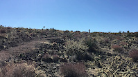
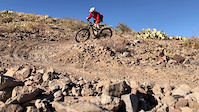
First, start by Climbing the north side of Beale Loop and get ready to hate life because this is a rocky mess of a trail with short steep burst with loose rock. I learned a few new ways to describe this terrain with a extensive use of words that start with F. Then hit Castle Rock Trail which gives you a break from obnoxious rocks and continuos climbing. A nice bit of up then down but still mad from the initial climb and you might be hoping you die rather than finish this loop because you keep climbing. At the end of the end of the trail, turn around, and head down Badger Trail and get ready to shred Wait nope you got one more hill you have to climb before anything pays off. Finally, you get to downhill stop put your shocks in pleasure mode and get ready to shred enjoy whipping down the side of the mountain that just keeps going. I was honestly, impressed how long I got to go downhill coming from Breckenridge last week. It definitely could use some jumps and banked corners.

Did you enjoy the downhill? Because now you are going to keep climbing until you reach the top of Sidewinder Trail which you expect to be nice and groomed like the pictures show. Nope, this is a washed out mess of a trail that will make you hate gravity. But you are nearly there head up to the main junction and head north on Rattler Trail if you want an extra climb and loop around Castle Rock Trail one more time to enjoy a long downhill on Rattler Trail. Rattler Trail is a fun mess of rocks that you can't get going that fast on due to their positioning. But enjoy it for what it is and ride it all the way back to the parking lot. Don't forget to give Beale Loop the finger in your passing.

Detailed Description
Beal Banger is a 22 mile popular intermediate route located near Kingman Arizona. This mountain bike only route can be used both directions and has a moderate overall physical rating. This route includes 10 trails. This route climbs 2,782 ft with a max elevation of 4,544 ft then descends -2,790 ft.

Trail Issues on Route

  • Minor Issue / Yellow: 1 trail (newest: Jan 19, 2023)
Local Trail Association
Local trail association
Colorado River Area Trail Alliance
Please consider joining or donating to the local riding association to support trail development & maintenance.
Donate to earn trail karma!

Stats

  • Distance
    22 miles
  • Avg time
    3 hr 23 min
  • Altitude min
    3,461 ft
  • Altitude start
    3,625 ft
  • Altitude end
    3,619 ft
  • Climb
    2,782 ft
  • Descent
    -2,790 ft
  • Grade max
    -40.4%
  • Grade min
    47.9%
  • Distance climb
    10 miles
  • Distance down
    11 miles
  • Distance flat
    4,528 ft

23 Reviews & Comments


We hope you've been enjoying Trailforks!

Create a FREE account to view route comments and much more.

Trails in Route

Camp Beale Loop1 mile
Badger3 miles
Sidewinder3 miles
Rattler1 mile
Castle Rock1,854 ft
Castle Rock1 mile
Rattler1 mile
Camp Beale Loop2,484 ft

Details

  • Riding area
  • Primary Activity
    Mountain Bike
  • Difficulty rating
    Blue
  • Route Type
    Loop
  • Bike type
    AM, XC, Fat, Uni
  • Direction
    Both Directions
  • Physical rating
    Moderate
Avg: 4 (2 votes)
close
3D
Trail Conditions
  • Unknown
  • Snow Groomed
  • Snow Packed
  • Snow Covered
  • Snow Cover Partial
  • Freeze/thaw Cycle
  • Icy
  • Prevalent Mud
  • Wet
  • Variable
  • Ideal
  • Dry
  • Very Dry
Trail Flow (Ridden Direction)
Trailforks scans users ridelogs to determine the most popular direction each trail is ridden. A good flowing trail network will have most trails flowing in a single direction according to their intension.
The colour categories are based on what percentage of riders are riding a trail in its intended direction.
  • > 96%
  • > 90%
  • > 80%
  • > 70%
  • > 50%
  • < 50%
  • bi-directional trail
  • no data
Trail Last Ridden
Trailforks scans ridelogs to determine the last time a trail was ridden.
  • < 2 days
  • < 1 week
  • < 2 weeks
  • < 1 month
  • < 6 months
  • > 6 months
Trail Ridden Direction
The intended direction a trail should be ridden.
  • Downhill Only
  • Downhill Primary
  • Both Directions
  • Uphill Primary
  • Uphill Only
  • One Direction
Contribute Details
Colors indicate trail is missing specified detail.
  • Description
  • Photos
  • Description & Photos
  • Videos
Trail Popularity ?
Trailforks scans ridelogs to determine which trails are ridden the most in the last 9 months. Trails are compared with nearby trails in the same city region with a possible 25 colour shades. Think of this as a heatmap, more rides = more kinetic energy = warmer colors.
  • most popular
  • popular
  • less popular
  • not popular
ATV/ORV/OHV Filter
Max Vehicle Width
inches
US Cell Coverage
Legend
cell carrier legend

Radar Time
Activity Recordings
Trailforks uses anonymized public activity data. ?
Activity Recordings
Trailforks uses anonymized public activity data. ?
Personal Heatmap
Activity Types
all / none
Options
2
Date range month
Winter Trails
Warning A routing network for winter maps does not exist. Selecting trails using the winter trails layer has been disabled.
Missing Trails
Most Popular
Least Popular
Trails are colored based on popularity. The more popular a trail is, the more red. Less popular trails trend towards green.
Jump Magnitude Heatmap
Heatmap of where riders jump on trails. Zoom in to see individual jumps, click circles to view jump details.
BC Backroad Status

Service Road Atlas is a free to use, community-driven service for viewing and creating reports on the numerous back-country service roads around B.C. and Alberta.

map legend
Slope Aspect
Direction the slope faces
Flat N NE E SE S SW W NW
Trails Deemphasized
Trails are shown in grey.
disable
Only show trails with no bike usage.
Enable
Suggested Layers
Based on selected activity type

    Save the current map location and zoom level as your default home location whenever this page is loaded.

    Save
    Trail transparency
    70
    69
    49
    51
    Chollo gap
    Chollo gap
    trail: Rattler
    0:12 | 158 | comments: 4 | favs:
    Feb 22, 2021
    Optional stepdown gap over a cholla cactus. 12 feet to the back side, with room to go deeper. Rider: Edwin the owner of LBS, The SpokesMann
    .corner
    .corner
    trail: Rattler
    0:09 | | comments: 0 | favs:
    Nov 30, 2020
    slo-mo turning

    Recent Trail Reports Along Route

    statustraildateconditiondescription
    Badger
    Apr 24, 2026 @ 9:56pm (America/Phoenix)
    Apr 24, 2026
    Dry and a little loose. Rough as a climb but a fun downhill. Upper switchbacks would probably be more fun on 26” wheels but a good trail overall.
    Camp Beale Loop
    Dec 4, 2025 @ 1:24pm (America/Phoenix)
    Dec 4, 2025
    Castle Rock
    Apr 13, 2023 @ 10:02am
    Apr 13, 2023
    Rattler
    Jan 19, 2023 @ 10:20am
    Jan 19, 2023
    Sidewinder
    Nov 2, 2021 @ 7:54pm
    Nov 2, 2021
    2 rock projects have been completed on this trail. Catclaw needs trimmed. Trail crew will be on the project finishing another couple rock projects and widening turns in late November 2021.
    more reports »
    • By camelkicker & contributors
    • #8391 - 1,460 views

    Hit the Trail

    Open in App

    Get this route on your phone instantly.

    Download Route

    Save to wishlist, Garmin & download.