3.5 miles
Distance
462 ft
Climb
-462 ft
Descent
4,583 ft
High Point
4,282 ft
Altitude min
4,282 ft
Altitude start
4,281 ft
Altitude end
-28.5%
Grade max
34%
Grade min
2 miles
Distance climb
2 miles
Distance down
1,696 ft
Distance flat

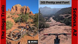
EXPERTS ONLY: Fry up some bacon and get ready for the Hogs. Some of Sedona's most technically demanding trails, you'll need some strong climbing skills as you climb the first portion of Broken Arrow and continue on to High on the Hog. Exposed, highly technical traversing leads you to committal rock moves as you continue on to Hog Heaven. The lines can be tricky, so be on your toes. Everything starts to ease off as you hit Hog Wash and head back to the TH. Definitely worth it if you are feeling strong and on your A-game. Once you know the loop, go back for second helping. The flow is a lot easier to find once you know the lines.

Detailed Description
Broken Arrow 3 is a 3 mile popular expert route located near Sedona Arizona. This mountain bike primary route can be used one direction and has a extreme overall physical rating. This route includes 5 trails. This route climbs 462 ft with a max elevation of 4,583 ft then descends -462 ft.
Local Trail Association
Please consider joining or donating to the local riding association to support trail development & maintenance.
Donate to earn trail karma!

Stats

  • Distance
    3 miles
  • Avg time
    1 hr 3 min
  • Altitude min
    4,282 ft
  • Altitude start
    4,282 ft
  • Altitude end
    4,281 ft
  • Climb
    462 ft
  • Descent
    -462 ft
  • Grade max
    -28.5%
  • Grade min
    34%
  • Distance climb
    2 miles
  • Distance down
    2 miles
  • Distance flat
    1,696 ft

42 Reviews & Comments


We hope you've been enjoying Trailforks!

Create a FREE account to view route comments and much more.

Trails in Route

Broken Arrow4,957 ft
High On The Hog1,864 ft
Hog Heaven4,183 ft
Hogwash2,703 ft
Broken Arrow883 ft

Details

  • Riding area
  • Primary Activity
    Mountain Bike
  • Other Activities
    • Hike
    • Trail Running
  • Difficulty rating
    Black Diamond
  • Route Type
    Loop
  • eBike Allowed
  • Bike type
    AM
  • Direction
    One Direction
  • Physical rating
    Extreme
  • Ridelogs
    207
no votes yet
close
3D
Trail Conditions
  • Unknown
  • Snow Groomed
  • Snow Packed
  • Snow Covered
  • Snow Cover Partial
  • Freeze/thaw Cycle
  • Icy
  • Prevalent Mud
  • Wet
  • Variable
  • Ideal
  • Dry
  • Very Dry
Trail Flow (Ridden Direction)
Trailforks scans users ridelogs to determine the most popular direction each trail is ridden. A good flowing trail network will have most trails flowing in a single direction according to their intension.
The colour categories are based on what percentage of riders are riding a trail in its intended direction.
  • > 96%
  • > 90%
  • > 80%
  • > 70%
  • > 50%
  • < 50%
  • bi-directional trail
  • no data
Trail Last Ridden
Trailforks scans ridelogs to determine the last time a trail was ridden.
  • < 2 days
  • < 1 week
  • < 2 weeks
  • < 1 month
  • < 6 months
  • > 6 months
Trail Ridden Direction
The intended direction a trail should be ridden.
  • Downhill Only
  • Downhill Primary
  • Both Directions
  • Uphill Primary
  • Uphill Only
  • One Direction
Contribute Details
Colors indicate trail is missing specified detail.
  • Description
  • Photos
  • Description & Photos
  • Videos
Trail Popularity ?
Trailforks scans ridelogs to determine which trails are ridden the most in the last 9 months. Trails are compared with nearby trails in the same city region with a possible 25 colour shades. Think of this as a heatmap, more rides = more kinetic energy = warmer colors.
  • most popular
  • popular
  • less popular
  • not popular
ATV/ORV/OHV Filter
Max Vehicle Width
inches
US Cell Coverage
Legend
cell carrier legend

Radar Time
Activity Recordings
Trailforks uses anonymized public activity data. ?
Activity Recordings
Trailforks uses anonymized public activity data. ?
Personal Heatmap
Activity Types
all / none
Options
2
Date range month
Winter Trails
Warning A routing network for winter maps does not exist. Selecting trails using the winter trails layer has been disabled.
Missing Trails
Most Popular
Least Popular
Trails are colored based on popularity. The more popular a trail is, the more red. Less popular trails trend towards green.
Jump Magnitude Heatmap
Heatmap of where riders jump on trails. Zoom in to see individual jumps, click circles to view jump details.
BC Backroad Status

Service Road Atlas is a free to use, community-driven service for viewing and creating reports on the numerous back-country service roads around B.C. and Alberta.

map legend
Slope Aspect
Direction the slope faces
Flat N NE E SE S SW W NW
Trails Deemphasized
Trails are shown in grey.
disable
Only show trails with no bike usage.
Enable
Suggested Layers
Based on selected activity type

    Save the current map location and zoom level as your default home location whenever this page is loaded.

    Save
    Trail transparency
    • Singletrack
    776
    861
    1,510 | 1 faves
    1,652
    youtuber Sedona's Hogs Trails are awesome! | Mountain...
    Sedona's Hogs Trails are awesome! | Mountain Biking Arizona
    trail: Hogwash
    36:46 | 31 | comments: 0 | favs:
    Apr 24, 2026
    youtuber Sedona's Hogs Trails are awesome! | Mountain...
    Sedona's Hogs Trails are awesome! | Mountain Biking Arizona
    trail: Hog Heaven
    36:46 | 32 | comments: 0 | favs:
    Apr 24, 2026

    Recent Trail Reports Along Route

    statustraildateconditiondescription
    Hog Heaven
    Mar 24, 2026 @ 7:36am (America/Phoenix)
    Mar 24, 2026
    Hogwash
    Mar 24, 2026 @ 7:36am (America/Phoenix)
    Mar 24, 2026
    High On The Hog
    Mar 24, 2026 @ 7:36am (America/Phoenix)
    Mar 24, 2026
    Broken Arrow
    Feb 7, 2026 @ 9:10am (America/Phoenix)
    Feb 7, 2026
    more reports »
    • By MollyJoyceTF Pro & contributors
    • #17607 - 1,085 views

    Hit the Trail

    Open in App

    Get this route on your phone instantly.

    Download Route

    Save to wishlist, Garmin & download.