7.4 miles
Distance
1,788 ft
Climb
-1,829 ft
Descent
1,594 ft
High Point
-41 ft
Altitude change
387 ft
Altitude min
428 ft
Altitude start
387 ft
Altitude end
-0.1%
Grade
-81.3%
Grade max
49.7%
Grade min
4 miles
Distance climb
3 miles
Distance down
1,093 ft
Distance flat

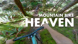
Push up. Enjoy the Down.

Burley AND Quick-E makes you go up the climb twice but it is sooo worth it.

Detailed Description
Burley & Quick-E Loop is a 7 mile popular expert route located near Powell River British Columbia. This mountain bike only route. This route includes 2 trails. This route climbs 1,788 ft with a max elevation of 1,594 ft then descends -1,829 ft.

Trail Issues on Route

  • Minor Issue / Yellow: 1 trail (newest: May 6, 2026)
Local Trail Association
Local trail association
Qathet Regional Cycling Association (qrca.ca)
Please consider joining or donating to the local riding association to support trail development & maintenance.
Donate to earn trail karma!

Stats

  • Distance
    7 miles
  • Avg time
    1 hr 29 min
  • Altitude change
    -41 ft
  • Altitude min
    387 ft
  • Altitude start
    428 ft
  • Altitude end
    387 ft
  • Climb
    1,788 ft
  • Descent
    -1,829 ft
  • Grade
    -0.1%
  • Grade max
    -81.3%
  • Grade min
    49.7%
  • Distance climb
    4 miles
  • Distance down
    3 miles
  • Distance flat
    1,093 ft

7 Reviews & Comments


We hope you've been enjoying Trailforks!

Create a FREE account to view route comments and much more.

Trails in Route

Retrograde2,792 ft
Quick-E3,264 ft

Details

  • Featured
  • Riding area
  • Primary Activity
    Mountain Bike
  • Difficulty rating
    Black Diamond
  • Ridelogs
    9
Avg: 3 (4 votes)
close
3D
Trail Conditions
  • Unknown
  • Snow Groomed
  • Snow Packed
  • Snow Covered
  • Snow Cover Partial
  • Freeze/thaw Cycle
  • Icy
  • Prevalent Mud
  • Wet
  • Variable
  • Ideal
  • Dry
  • Very Dry
Trail Flow (Ridden Direction)
Trailforks scans users ridelogs to determine the most popular direction each trail is ridden. A good flowing trail network will have most trails flowing in a single direction according to their intension.
The colour categories are based on what percentage of riders are riding a trail in its intended direction.
  • > 96%
  • > 90%
  • > 80%
  • > 70%
  • > 50%
  • < 50%
  • bi-directional trail
  • no data
Trail Last Ridden
Trailforks scans ridelogs to determine the last time a trail was ridden.
  • < 2 days
  • < 1 week
  • < 2 weeks
  • < 1 month
  • < 6 months
  • > 6 months
Trail Ridden Direction
The intended direction a trail should be ridden.
  • Downhill Only
  • Downhill Primary
  • Both Directions
  • Uphill Primary
  • Uphill Only
  • One Direction
Contribute Details
Colors indicate trail is missing specified detail.
  • Description
  • Photos
  • Description & Photos
  • Videos
Trail Popularity ?
Trailforks scans ridelogs to determine which trails are ridden the most in the last 9 months. Trails are compared with nearby trails in the same city region with a possible 25 colour shades. Think of this as a heatmap, more rides = more kinetic energy = warmer colors.
  • most popular
  • popular
  • less popular
  • not popular
ATV/ORV/OHV Filter
Max Vehicle Width
inches
US Cell Coverage
Legend
cell carrier legend

Radar Time
Activity Recordings
Trailforks uses anonymized public activity data. ?
Activity Recordings
Trailforks uses anonymized public activity data. ?
Personal Heatmap
Activity Types
all / none
Options
2
Date range month
Winter Trails
Warning A routing network for winter maps does not exist. Selecting trails using the winter trails layer has been disabled.
Missing Trails
Most Popular
Least Popular
Trails are colored based on popularity. The more popular a trail is, the more red. Less popular trails trend towards green.
Jump Magnitude Heatmap
Heatmap of where riders jump on trails. Zoom in to see individual jumps, click circles to view jump details.
BC Backroad Status

Service Road Atlas is a free to use, community-driven service for viewing and creating reports on the numerous back-country service roads around B.C. and Alberta.

map legend
Slope Aspect
Direction the slope faces
Flat N NE E SE S SW W NW
Trails Deemphasized
Trails are shown in grey.
disable
Only show trails with no bike usage.
Enable
Suggested Layers
Based on selected activity type

    Save the current map location and zoom level as your default home location whenever this page is loaded.

    Save
    Trail transparency
    • Singletrack
    115
    108
    99
    114
    Yeah this place is the best. Mountain bike...
    Yeah this place is the best. Mountain bike riding in Powell River.
    trail: Quick-E
    23:09 | 88 | comments: 0 | favs:
    Nov 29, 2025
    POWELL RIVER MTB?
    POWELL RIVER MTB?
    trail: Quick-E
    8:27 | 231 | comments: 0 | favs:
    May 27, 2025

    Recent Trail Reports Along Route

    statustraildateconditiondescription
    Quick-E
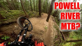
    May 6, 2026 @ 8:38pm (America/Vancouver)
    May 6, 2026
    trail is open, dry but still loads of fun
    Retrograde
    Aug 19, 2025 @ 4:12pm
    Aug 19, 2025
    more reports »
    • By bikebbTF Pro & contributors
    • #23687 - 1,630 views

    Hit the Trail

    Open in App

    Get this route on your phone instantly.

    Download Route

    Save to wishlist, Garmin & download.