9.7 miles
Distance
2,009 ft
Climb
-1,972 ft
Descent
3,933 ft
High Point
37 ft
Altitude change
2,494 ft
Altitude min
2,503 ft
Altitude start
2,539 ft
Altitude end
0.1%
Grade
-40.8%
Grade max
52.7%
Grade min
4 miles
Distance climb
5 miles
Distance down
4,501 ft
Distance flat

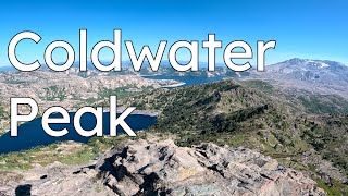
The trail consists of a loop around Coldwater lake that includes three trails (211, 230, & 230A) that can be ridden clockwise or counterclockwise. If you ride Clockwise, the 230 trail is a steep 2 mile ~1500ft switchback climb out of the lake that at times is a hike-a-bike, but there is a great 3-4 mile decent down the 230A trail to the trailhead.

Detailed Description
Coldwater Lake Loop is a 10 mile popular intermediate route located near Cougar Washington. This mountain bike only route can be used both directions and has a moderate overall physical rating. This route includes 3 trails. This route climbs 2,009 ft with a max elevation of 3,933 ft then descends -1,972 ft.

Trail Issues on Route

  • Minor Issue / Yellow: 1 trail (newest: Oct 18, 2025)
Local Trail Association
Local trail association
Northwest Trail Alliance (nw-trail.org)
Please consider joining or donating to the local riding association to support trail development & maintenance.
Donate to earn trail karma!

Stats

  • Distance
    10 miles
  • Avg time
    2 hr 40 min
  • Altitude min
    2,494 ft
  • Altitude start
    2,503 ft
  • Altitude end
    2,539 ft
  • Climb
    2,009 ft
  • Descent
    -1,972 ft
  • Grade
    0.1%
  • Grade max
    -40.8%
  • Grade min
    52.7%
  • Distance climb
    4 miles
  • Distance down
    5 miles
  • Distance flat
    4,501 ft

1 Review & Comments


We hope you've been enjoying Trailforks!

Create a FREE account to view route comments and much more.

Trails in Route

Details

  • Riding area
  • Primary Activity
    Mountain Bike
  • Difficulty rating
    Blue
  • Route Type
    Loop
  • Bike type
    AM, XC
  • Direction
    Both Directions
  • Physical rating
    Moderate
  • Ridelogs
    8
Avg: 3 (1 votes)
close
3D
Trail Conditions
  • Unknown
  • Snow Groomed
  • Snow Packed
  • Snow Covered
  • Snow Cover Partial
  • Freeze/thaw Cycle
  • Icy
  • Prevalent Mud
  • Wet
  • Variable
  • Ideal
  • Dry
  • Very Dry
Trail Flow (Ridden Direction)
Trailforks scans users ridelogs to determine the most popular direction each trail is ridden. A good flowing trail network will have most trails flowing in a single direction according to their intension.
The colour categories are based on what percentage of riders are riding a trail in its intended direction.
  • > 96%
  • > 90%
  • > 80%
  • > 70%
  • > 50%
  • < 50%
  • bi-directional trail
  • no data
Trail Last Ridden
Trailforks scans ridelogs to determine the last time a trail was ridden.
  • < 2 days
  • < 1 week
  • < 2 weeks
  • < 1 month
  • < 6 months
  • > 6 months
Trail Ridden Direction
The intended direction a trail should be ridden.
  • Downhill Only
  • Downhill Primary
  • Both Directions
  • Uphill Primary
  • Uphill Only
  • One Direction
Contribute Details
Colors indicate trail is missing specified detail.
  • Description
  • Photos
  • Description & Photos
  • Videos
Trail Popularity ?
Trailforks scans ridelogs to determine which trails are ridden the most in the last 9 months. Trails are compared with nearby trails in the same city region with a possible 25 colour shades. Think of this as a heatmap, more rides = more kinetic energy = warmer colors.
  • most popular
  • popular
  • less popular
  • not popular
ATV/ORV/OHV Filter
Max Vehicle Width
inches
US Cell Coverage
Legend
cell carrier legend

Radar Time
Activity Recordings
Trailforks uses anonymized public activity data. ?
Activity Recordings
Trailforks uses anonymized public activity data. ?
Personal Heatmap
Activity Types
all / none
Options
2
Date range month
Winter Trails
Warning A routing network for winter maps does not exist. Selecting trails using the winter trails layer has been disabled.
Missing Trails
Most Popular
Least Popular
Trails are colored based on popularity. The more popular a trail is, the more red. Less popular trails trend towards green.
Jump Magnitude Heatmap
Heatmap of where riders jump on trails. Zoom in to see individual jumps, click circles to view jump details.
BC Backroad Status

Service Road Atlas is a free to use, community-driven service for viewing and creating reports on the numerous back-country service roads around B.C. and Alberta.

map legend
Slope Aspect
Direction the slope faces
Flat N NE E SE S SW W NW
Trails Deemphasized
Trails are shown in grey.
disable
Only show trails with no bike usage.
Enable
Suggested Layers
Based on selected activity type

    Save the current map location and zoom level as your default home location whenever this page is loaded.

    Save
    Trail transparency
    • Singletrack
    92
    133
    129
    100
    youtuber Coldwater Peak
    Coldwater Peak
    16:10 | 209 | comments: 0 | favs:
    Sep 27, 2023
    youtuber South Coldwater Trail to St. Helens Lake
    South Coldwater Trail to St. Helens Lake
    14:13 | 688 | comments: 0 | favs:
    Jul 3, 2020

    Recent Trail Reports Along Route

    statustraildateconditiondescription
    Coldwater Trail
    Oct 18, 2025 @ 4:26pm (America/Los_Angeles)
    Oct 18, 2025
    Rode 1.5 miles from South Coldwater Trail junction to the saddle. Pretty overgrown as you approach the saddle.
    South Coldwater Trail
    Oct 18, 2025 @ 8:56am (America/Los_Angeles)
    Oct 18, 2025
    Running great!
    Lakes Trail
    Jun 2, 2025 @ 7:57pm
    Jun 2, 2025
    NWTA did lots of maintenance! Go ride it!
    more reports »
    • By TheBikeNerdTF Pro NWTA & contributors
    • #19254 - 2,768 views

    Hit the Trail

    Open in App

    Get this route on your phone instantly.

    Download Route

    Save to wishlist, Garmin & download.