10.1 miles
Distance
707 ft
Climb
-714 ft
Descent
327 ft
High Point
-6 ft
Altitude change
137 ft
Altitude min
327 ft
Altitude start
322 ft
Altitude end
-18%
Grade max
21.2%
Grade min
4 miles
Distance climb
4 miles
Distance down
2 miles
Distance flat

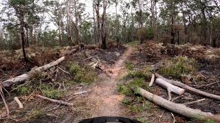
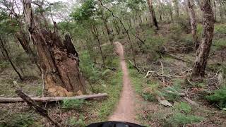
Full loop of the Colquhoun MTB park - a classic single track adventure with some fast and flowy sections thrown in for good measure.

Plenty of timber features like log rollovers, bridges, optional drops and jumps to keep things interesting.

Detailed Description
Colquhoun Full Lap is a 10 mile popular intermediate route located near Lakes Entrance. This mountain bike primary route can be used one direction and has a moderate overall physical rating. This route includes 9 trails. This route climbs 707 ft with a max elevation of 327 ft then descends -714 ft.

Trail Issues on Route

  • Significant Issue / Amber: 1 trail (newest: Sep 10, 2024)
  • Minor Issue / Yellow: 2 trails (newest: Sep 1, 2024)
Local Trail Association
Local trail association
Mountain Biking East Gippsland Inc (mtbeg.com.au)
Please consider joining or donating to the local riding association to support trail development & maintenance.
Donate to earn trail karma!

Stats

  • Distance
    10 miles
  • Altitude min
    137 ft
  • Altitude start
    327 ft
  • Altitude end
    322 ft
  • Climb
    707 ft
  • Descent
    -714 ft
  • Grade max
    -18%
  • Grade min
    21.2%
  • Distance climb
    4 miles
  • Distance down
    4 miles
  • Distance flat
    2 miles

6 Reviews & Comments


We hope you've been enjoying Trailforks!

Create a FREE account to view route comments and much more.

Trails in Route

Details

  • Riding area
  • Primary Activity
    Mountain Bike
  • Other Activities
    • E-Bike
  • Difficulty rating
    Blue
  • Route Type
    Loop
  • eBike Allowed
  • Bike type
    AM, XC
  • Direction
    One Direction
  • Physical rating
    Moderate

Directions

  1. Walk southeast on Start Line.
  2. Continue for 700 meters.
  3. Bear right onto Sinkhole.
  4. Continue for 1 kilometer.
  5. Bear left onto Howards Track.
  6. Continue for 1.5 kilometers.
  7. Bear left onto Lollipop Track.
  8. Continue for 7 kilometers.
  9. Turn right onto Oil Bore Track.
  10. Continue for 1.5 kilometers.
  11. Turn right onto Gippsland Lakes Discovery Trail.
  12. Continue for 1 kilometer.
  13. Turn right onto Tin Shed Track.
  14. Continue for 2 kilometers.
  15. Turn left onto Pussy Log Track.
  16. Continue for 1.5 kilometers.
no votes yet
close
3D
Trail Conditions
  • Unknown
  • Snow Groomed
  • Snow Packed
  • Snow Covered
  • Snow Cover Partial
  • Freeze/thaw Cycle
  • Icy
  • Prevalent Mud
  • Wet
  • Variable
  • Ideal
  • Dry
  • Very Dry
Trail Flow (Ridden Direction)
Trailforks scans users ridelogs to determine the most popular direction each trail is ridden. A good flowing trail network will have most trails flowing in a single direction according to their intension.
The colour categories are based on what percentage of riders are riding a trail in its intended direction.
  • > 96%
  • > 90%
  • > 80%
  • > 70%
  • > 50%
  • < 50%
  • bi-directional trail
  • no data
Trail Last Ridden
Trailforks scans ridelogs to determine the last time a trail was ridden.
  • < 2 days
  • < 1 week
  • < 2 weeks
  • < 1 month
  • < 6 months
  • > 6 months
Trail Ridden Direction
The intended direction a trail should be ridden.
  • Downhill Only
  • Downhill Primary
  • Both Directions
  • Uphill Primary
  • Uphill Only
  • One Direction
Contribute Details
Colors indicate trail is missing specified detail.
  • Description
  • Photos
  • Description & Photos
  • Videos
Trail Popularity ?
Trailforks scans ridelogs to determine which trails are ridden the most in the last 9 months. Trails are compared with nearby trails in the same city region with a possible 25 colour shades. Think of this as a heatmap, more rides = more kinetic energy = warmer colors.
  • most popular
  • popular
  • less popular
  • not popular
ATV/ORV/OHV Filter
Max Vehicle Width
inches
US Cell Coverage
Legend
cell carrier legend

Radar Time
Activity Recordings
Trailforks uses anonymized public activity data. ?
Activity Recordings
Trailforks uses anonymized public activity data. ?
Personal Heatmap
Activity Types
all / none
Options
2
Date range month
Winter Trails
Warning A routing network for winter maps does not exist. Selecting trails using the winter trails layer has been disabled.
Missing Trails
Most Popular
Least Popular
Trails are colored based on popularity. The more popular a trail is, the more red. Less popular trails trend towards green.
Jump Magnitude Heatmap
Heatmap of where riders jump on trails. Zoom in to see individual jumps, click circles to view jump details.
BC Backroad Status

Service Road Atlas is a free to use, community-driven service for viewing and creating reports on the numerous back-country service roads around B.C. and Alberta.

map legend
Slope Aspect
Direction the slope faces
Flat N NE E SE S SW W NW
Trails Deemphasized
Trails are shown in grey.
disable
Only show trails with no bike usage.
Enable
Suggested Layers
Based on selected activity type

    Save the current map location and zoom level as your default home location whenever this page is loaded.

    Save
    Trail transparency
    • Singletrack
    64
    65
    64
    52
    Log Track - Colquhoun MTB Track
    Log Track - Colquhoun MTB Track
    trail: Log Track
    5:09 | 448 | comments: 0 | favs:
    May 5, 2021
    Lollipop Track - Colquhoun MTB Park
    Lollipop Track - Colquhoun MTB Park
    6:37 | 1785 | comments: 0 | favs:
    May 5, 2021

    Recent Trail Reports Along Route

    statustraildateconditiondescription
    Lollipop Track
    Jan 24, 2026 @ 9:41am (Australia/Melbourne)
    Jan 23, 2026
    Howards Track
    Jan 24, 2026 @ 9:41am (Australia/Melbourne)
    Jan 23, 2026
    Pussy Log Track
    Jan 24, 2026 @ 9:41am (Australia/Melbourne)
    Jan 23, 2026
    Oil Bore Track
    Apr 5, 2025 @ 1:52pm
    Apr 5, 2025
    Large tree down across trail, blocking trail
    Log Track
    Oct 14, 2024 @ 9:15pm
    Oct 14, 2024
    more reports »
    • By flyingbananaTF Pro MTBEG MTBEG & contributors
    • #51474 - 722 views

    Hit the Trail

    Open in App

    Get this route on your phone instantly.

    Download Route

    Save to wishlist, Garmin & download.