13.9 miles
Distance
1,764 ft
Climb
-1,772 ft
Descent
568 ft
High Point
-7 ft
Altitude change
81 ft
Altitude min
394 ft
Altitude start
387 ft
Altitude end
-41.5%
Grade max
27.5%
Grade min
7 miles
Distance climb
5 miles
Distance down
2 miles
Distance flat

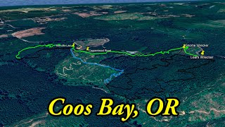
Try your hand at all the downhill at Whiskey Run with plenty of climbing involved. Get extra laps on Hey Bub or Joe Ben & Jerry's for a few extra miles or lap Boot, Scoot'n, Boogie to dial in your jumps. This route has jumps, berms, gaps, and plenty of optional hips to hit and make your ride more playful.

Detailed Description
Downhills 1 is a 14 mile moderately popular expert route located near Coos Bay Oregon. This mountain bike only route can be used one direction and has a hard overall physical rating. This route includes 52 trails. This route climbs 1,764 ft with a max elevation of 568 ft then descends -1,772 ft.

Trail Issues on Route

  • Significant Issue / Amber: 1 trail (newest: Jun 19, 2026)
  • Minor Issue / Yellow: 3 trails (newest: Sep 20, 2025)
Local Trail Association
Local trail association
Wild Coast Trails Association (wildcoasttrails.org)
Please consider joining or donating to the local riding association to support trail development & maintenance.
Donate to earn trail karma!

Stats

  • Distance
    14 miles
  • Avg time
    2 hr 30 min
  • Altitude min
    81 ft
  • Altitude start
    394 ft
  • Altitude end
    387 ft
  • Climb
    1,764 ft
  • Descent
    -1,772 ft
  • Grade max
    -41.5%
  • Grade min
    27.5%
  • Distance climb
    7 miles
  • Distance down
    5 miles
  • Distance flat
    2 miles

30 Reviews & Comments


We hope you've been enjoying Trailforks!

Create a FREE account to view route comments and much more.

Details

  • Riding area
  • Primary Activity
    Mountain Bike
  • Difficulty rating
    Black Diamond
  • Route Type
    Loop
  • eBike Allowed
  • Bike type
    AM
  • Direction
    One Direction
  • Physical rating
    Hard
  • Ridelogs
    5
no votes yet
close
3D
Trail Conditions
  • Unknown
  • Snow Groomed
  • Snow Packed
  • Snow Covered
  • Snow Cover Partial
  • Freeze/thaw Cycle
  • Icy
  • Prevalent Mud
  • Wet
  • Variable
  • Ideal
  • Dry
  • Very Dry
Trail Flow (Ridden Direction)
Trailforks scans users ridelogs to determine the most popular direction each trail is ridden. A good flowing trail network will have most trails flowing in a single direction according to their intension.
The colour categories are based on what percentage of riders are riding a trail in its intended direction.
  • > 96%
  • > 90%
  • > 80%
  • > 70%
  • > 50%
  • < 50%
  • bi-directional trail
  • no data
Trail Last Ridden
Trailforks scans ridelogs to determine the last time a trail was ridden.
  • < 2 days
  • < 1 week
  • < 2 weeks
  • < 1 month
  • < 6 months
  • > 6 months
Trail Ridden Direction
The intended direction a trail should be ridden.
  • Downhill Only
  • Downhill Primary
  • Both Directions
  • Uphill Primary
  • Uphill Only
  • One Direction
Contribute Details
Colors indicate trail is missing specified detail.
  • Description
  • Photos
  • Description & Photos
  • Videos
Trail Popularity ?
Trailforks scans ridelogs to determine which trails are ridden the most in the last 9 months. Trails are compared with nearby trails in the same city region with a possible 25 colour shades. Think of this as a heatmap, more rides = more kinetic energy = warmer colors.
  • most popular
  • popular
  • less popular
  • not popular
ATV/ORV/OHV Filter
Max Vehicle Width
inches
US Cell Coverage
Legend
cell carrier legend

Radar Time
Activity Recordings
Trailforks uses anonymized public activity data. ?
Activity Recordings
Trailforks uses anonymized public activity data. ?
Personal Heatmap
Activity Types
all / none
Options
2
Date range month
Winter Trails
Warning A routing network for winter maps does not exist. Selecting trails using the winter trails layer has been disabled.
Missing Trails
Most Popular
Least Popular
Trails are colored based on popularity. The more popular a trail is, the more red. Less popular trails trend towards green.
Jump Magnitude Heatmap
Heatmap of where riders jump on trails. Zoom in to see individual jumps, click circles to view jump details.
BC Backroad Status

Service Road Atlas is a free to use, community-driven service for viewing and creating reports on the numerous back-country service roads around B.C. and Alberta.

map legend
Slope Aspect
Direction the slope faces
Flat N NE E SE S SW W NW
Trails Deemphasized
Trails are shown in grey.
disable
Only show trails with no bike usage.
Enable
Suggested Layers
Based on selected activity type

    Save the current map location and zoom level as your default home location whenever this page is loaded.

    Save
    Trail transparency
    • Singletrack
    • Unpaved
    • Paved
    82
    651
    814
    557
    youtuber Sweet, MTB flow trails in Coos Bay, OR -...
    Sweet, MTB flow trails in Coos Bay, OR - Whiskey Run Trails
    11:18 | 103 | comments: 0 | favs:
    Oct 17, 2025
    youtuber Whiskey Trails: Gnome Wrecker
    Whiskey Trails: Gnome Wrecker
    11:18 | 92 | comments: 0 | favs:
    Oct 17, 2025

    Recent Trail Reports Along Route

    statustraildateconditiondescription
    Gnome Wrecker
    Jun 19, 2026 @ 3:19pm (America/Los_Angeles)
    Jun 19, 2026
    Amazing as of a few days ago! Very fast in the forest, with a few loamy spots that rip! Get it!
    Boot Scoot
    Jun 19, 2026 @ 3:11pm (America/Los_Angeles)
    Jun 19, 2026
    VERY overgrown, almost unrideable and completely covered in grass in a few sections. Top section doesn’t have too much grass and is ok. This trail really needs some work to get it to a place where it is even ok to ride.
    Upper Captain Blacklock
    Jun 18, 2026 @ 1:33pm (America/Los_Angeles)
    Jun 18, 2026
    Sour Mash (Upper)
    Jun 18, 2026 @ 1:33pm (America/Los_Angeles)
    Jun 18, 2026
    Bootlegger
    Jun 18, 2026 @ 1:33pm (America/Los_Angeles)
    Jun 18, 2026
    more reports »
    • By whiskeyqueenTF Pro & contributors
    • #12033 - 1,189 views

    Hit the Trail

    Open in App

    Get this route on your phone instantly.

    Download Route

    Save to wishlist, Garmin & download.