
Open in App
Get this route on your phone instantly.
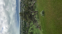
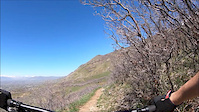
Dry Canyon Loop - Start by Police Shooting Range. BST to Shooter, to Crankland, to Betty, up to the altar (big pile of rocks). Lament up and around Dry Canyon through Crop Circles, back to BST.
The climb up through the scrub oak is strenuous, but enjoyable. There are a lot of unmarked trail intersections on Crankland, so connecting to Betty might be tricky if you're unfamiliar with the area (bring a GPS). Most of the loop is scrub oak, so don't expect any shade. This is a good Spring/Fall or early morning ride. You can shorten the ride by coming down Dry Canyon (watch out for hikers), but you'll miss Crop Circles, which is probably the funnest part of the loop.
We hope you've been enjoying Trailforks!
Create a FREE account to view route comments and much more.
| 276 ft | |||||
| 1,266 ft | |||||
| 1,260 ft | |||||
| 2 miles | |||||
| 66 ft | |||||
| 23 ft | |||||
| 141 ft | |||||
| 259 ft | |||||
| 1,555 ft | |||||
| 1,637 ft | |||||
| 3,894 ft | |||||
| 33 ft | |||||
| 2,175 ft | |||||
| 4,993 ft | |||||
| 184 ft | |||||
| 1,841 ft | |||||
| 1,765 ft | |||||
| 4,826 ft | |||||
| 1,109 ft | |||||
| 4,249 ft | |||||
| 121 ft | |||||
| 3,694 ft | |||||
| 1,929 ft | |||||
| 3,281 ft |

Service Road Atlas is a free to use, community-driven service for viewing and creating reports on the numerous back-country service roads around B.C. and Alberta.
Save the current map location and zoom level as your default home location whenever this page is loaded.
Save