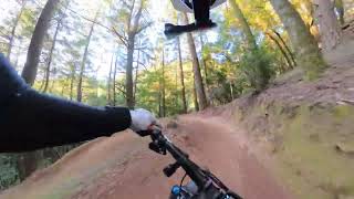
Quickest Route to Endor:
Park at White Hill Pass Bridge on SFD Blvd
Take White Hill Trail up or for quicker/steep hike a bike Martha McCormick Trail up from parking lot then take a right on the fire road then a left.
Need a Friends of Tamarancho Pass to enter Marin Counsel (BSA) Private Property
Do multiple laps (only one lap shown) get rad on the wooden features.
Alternate climb back up Dead Heffer FR
Local Trail Association
Marin Trail Stewards (marintrailstewards.org)Trail Products
Stats
-
Distance5 miles
-
Avg time1 hr 4 min
-
Altitude change8 ft
-
Altitude min518 ft
-
Altitude start518 ft
-
Altitude end525 ft
-
Climb869 ft
-
Descent-861 ft
-
Grade max-30.6%
-
Grade min32.3%
-
Distance climb2 miles
-
Distance down2 miles
-
Distance flat1,529 ft
17 Reviews & Comments
We hope you've been enjoying Trailforks!
Create a FREE account to view route comments and much more.
- Unknown
- Snow Groomed
- Snow Packed
- Snow Covered
- Snow Cover Partial
- Freeze/thaw Cycle
- Icy
- Prevalent Mud
- Wet
- Variable
- Ideal
- Dry
- Very Dry
The colour categories are based on what percentage of riders are riding a trail in its intended direction.
- > 96%
- > 90%
- > 80%
- > 70%
- > 50%
- < 50%
- bi-directional trail
- no data
- < 2 days
- < 1 week
- < 2 weeks
- < 1 month
- < 6 months
- > 6 months
- Downhill Only
- Downhill Primary
- Both Directions
- Uphill Primary
- Uphill Only
- One Direction
- Description
- Photos
- Description & Photos
- Videos
- most popular
- popular
- less popular
- not popular
Service Road Atlas is a free to use, community-driven service for viewing and creating reports on the numerous back-country service roads around B.C. and Alberta.
Save the current map location and zoom level as your default home location whenever this page is loaded.
Save- Singletrack
- Unpaved
Photos
Videos
Recent Trail Reports Along Route
- By Spindelatron
& contributors - #27170 - 1,974 views
