29.7 miles
Distance
7,323 ft
Climb
-7,081 ft
Descent
2 miles
High Point
242 ft
Altitude change
6,197 ft
Altitude min
6,605 ft
Altitude start
6,847 ft
Altitude end
0.2%
Grade
-83.3%
Grade max
63.3%
Grade min
17 miles
Distance climb
11 miles
Distance down
1 mile
Distance flat
This route is archived

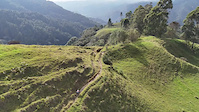
Ruta Enduro en el Valle del cocora, Tres Stages con variedad de terreno

Detailed Description
Enduro Salento is a 30 mile intermediate race route located near Armenia. This mountain bike only route can be used one direction and has a hard overall physical rating. This route includes 67 trails. This route climbs 7,323 ft with a max elevation of 10,542 ft then descends -7,081 ft.

Trail Issues on Route

  • Minor Issue / Yellow: 1 trail (newest: Aug 28, 2024)
Local Trail Association
Please consider joining or donating to the local riding association to support trail development & maintenance.
Donate to earn trail karma!

Stats

  • Distance
    30 miles
  • Avg time
    4 hr 48 min
  • Altitude min
    6,197 ft
  • Altitude start
    6,605 ft
  • Altitude end
    6,847 ft
  • Climb
    1 mile
  • Descent
    -7,081 ft
  • Grade
    0.2%
  • Grade max
    -83.3%
  • Grade min
    63.3%
  • Distance climb
    17 miles
  • Distance down
    11 miles
  • Distance flat
    1 mile

3 Reviews & Comments


We hope you've been enjoying Trailforks!

Create a FREE account to view route comments and much more.

Route Sections

1 Stage 1 - La Linea
2 Stage 2 - Alegrias
3 Stage 3 - Km8

Trails in Route

Details

  • Race Course
  • Riding area
  • Primary Activity
    Mountain Bike
  • Difficulty rating
    Blue
  • Route Type
    Loop
  • Bike type
    AM
  • Direction
    One Direction
  • Physical rating
    Hard
no votes yet
close
3D
Trail Conditions
  • Unknown
  • Snow Groomed
  • Snow Packed
  • Snow Covered
  • Snow Cover Partial
  • Freeze/thaw Cycle
  • Icy
  • Prevalent Mud
  • Wet
  • Variable
  • Ideal
  • Dry
  • Very Dry
Trail Flow (Ridden Direction)
Trailforks scans users ridelogs to determine the most popular direction each trail is ridden. A good flowing trail network will have most trails flowing in a single direction according to their intension.
The colour categories are based on what percentage of riders are riding a trail in its intended direction.
  • > 96%
  • > 90%
  • > 80%
  • > 70%
  • > 50%
  • < 50%
  • bi-directional trail
  • no data
Trail Last Ridden
Trailforks scans ridelogs to determine the last time a trail was ridden.
  • < 2 days
  • < 1 week
  • < 2 weeks
  • < 1 month
  • < 6 months
  • > 6 months
Trail Ridden Direction
The intended direction a trail should be ridden.
  • Downhill Only
  • Downhill Primary
  • Both Directions
  • Uphill Primary
  • Uphill Only
  • One Direction
Contribute Details
Colors indicate trail is missing specified detail.
  • Description
  • Photos
  • Description & Photos
  • Videos
Trail Popularity ?
Trailforks scans ridelogs to determine which trails are ridden the most in the last 9 months. Trails are compared with nearby trails in the same city region with a possible 25 colour shades. Think of this as a heatmap, more rides = more kinetic energy = warmer colors.
  • most popular
  • popular
  • less popular
  • not popular
ATV/ORV/OHV Filter
Max Vehicle Width
inches
US Cell Coverage
Legend
cell carrier legend

Radar Time
Activity Recordings
Trailforks uses anonymized public activity data. ?
Activity Recordings
Trailforks uses anonymized public activity data. ?
Personal Heatmap
Activity Types
all / none
Options
2
Date range month
Winter Trails
Warning A routing network for winter maps does not exist. Selecting trails using the winter trails layer has been disabled.
Missing Trails
Most Popular
Least Popular
Trails are colored based on popularity. The more popular a trail is, the more red. Less popular trails trend towards green.
Jump Magnitude Heatmap
Heatmap of where riders jump on trails. Zoom in to see individual jumps, click circles to view jump details.
BC Backroad Status

Service Road Atlas is a free to use, community-driven service for viewing and creating reports on the numerous back-country service roads around B.C. and Alberta.

map legend
Slope Aspect
Direction the slope faces
Flat N NE E SE S SW W NW
Trails Deemphasized
Trails are shown in grey.
disable
Only show trails with no bike usage.
Enable
Suggested Layers
Based on selected activity type

    Save the current map location and zoom level as your default home location whenever this page is loaded.

    Save
    Trail transparency
    • Singletrack
    25
    31
    26
    39
    Epic Andes: The treasures of hte colombian...
    Epic Andes: The treasures of hte colombian coffeelands
    trail: La Alegria
    4:42 | 30 | comments: 0 | favs:
    Oct 22, 2024
    Join us for the most epic journey through the stunning landscapes of Colombia’s coffee lands. Ride the top trails in Salento and the MTB capital...
    DH La Alegria, Salento, Quindio
    DH La Alegria, Salento, Quindio
    trail: La Alegria
    11:27 | 402 | comments: 0 | favs:
    Apr 7, 2015
    Por el bosque, potreros, canalones, rock gardens de todo. @tvs1988

    Recent Trail Reports Along Route

    statustraildateconditiondescription
    Km 8 - Salento
    Aug 28, 2024 @ 12:00pm
    Aug 28, 2024
    La Alegria
    Jan 10, 2024 @ 9:21am
    Jan 10, 2024
    more reports »
    • By Earango & contributors
    • #2155 - 2,054 views

    Hit the Trail

    Open in App

    Get this route on your phone instantly.

    Download Route

    Save to wishlist, Garmin & download.