7.0 miles
Distance
563 ft
Climb
-563 ft
Descent
68 ft
High Point
0 ft
Altitude change
12 ft
Altitude min
13 ft
Altitude start
13 ft
Altitude end
-21.7%
Grade max
28.9%
Grade min
2 miles
Distance climb
3 miles
Distance down
2 miles
Distance flat

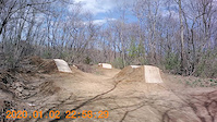
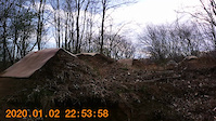
Unsanctioned: bikes may or may be allowed in some areas.

How to connect trails for best flow at Fort Lee

This route is Unsanctioned, Ride at your own Risk!

Detailed Description
Fort Lee is a 7 mile moderately popular intermediate unsanctioned route located near Salem Massachusetts. This mountain bike only route. This route includes 91 trails. This route climbs 563 ft with a max elevation of 68 ft then descends -563 ft.

Stats

  • Distance
    7 miles
  • Avg time
    45 min 36 sec
  • Altitude change
    0 ft
  • Altitude min
    12 ft
  • Altitude start
    13 ft
  • Altitude end
    13 ft
  • Climb
    563 ft
  • Descent
    -563 ft
  • Grade max
    -21.7%
  • Grade min
    28.9%
  • Distance climb
    2 miles
  • Distance down
    3 miles
  • Distance flat
    2 miles

3 Reviews & Comments


We hope you've been enjoying Trailforks!

Create a FREE account to view route comments and much more.

Trails in Route

Connector167 ft
S Hill187 ft
Cloud Candy633 ft
Braaap Honey!1,112 ft
High Voltage840 ft
Braaap Honey!650 ft
Sunset1,335 ft
Fort Lee / Cannon Hill236 ft
Berms1,171 ft
Berms Up and Out223 ft
Sunset492 ft
Berms568 ft
Sunset1,463 ft
Berms814 ft
Berms Up and Out856 ft
Berms420 ft
Fort Lee / Cannon Hill282 ft
Sunset643 ft
Suicide Pass1,493 ft
Fort Lee / Cannon Hill220 ft
Sunset1 mile
Braaap Honey!938 ft
High Voltage344 ft
Cloud Candy2,005 ft
Connector427 ft
Cloud Candy597 ft
Suicide Pass3,241 ft
Keno912 ft
Fort Perimeter Trail548 ft
Fort Lee / Cannon Hill1,470 ft
Sunset177 ft
High Voltage528 ft
Suicide Pass495 ft
Fort Perimeter Trail266 ft
Fort Lee / Cannon Hill243 ft
Sunset1,699 ft
Berms Roll In174 ft
Berms1,631 ft
Sunset1,004 ft
Berms Up and Out1 mile
Fort Lee / Cannon Hill607 ft
Sunset446 ft
Suicide Pass1,276 ft
Fort Lee / Cannon Hill230 ft
Sunset1 mile
Popcorn1,821 ft
Keno823 ft
S Hill295 ft
Cloud Candy2,014 ft
Suicide Pass1,568 ft
Braaap Honey!1,063 ft
High Voltage876 ft
Sunset1,388 ft
Fort Lee / Cannon Hill545 ft
High Voltage3,583 ft
Suicide Pass3,537 ft
Fort Perimeter Trail2,890 ft
Berms472 ft
Berms Up and Out1,808 ft
Berms617 ft
Sunset1,450 ft
Berms518 ft
Fort Lee / Cannon Hill1 mile
Sunset636 ft
High Voltage997 ft
Suicide Pass1,037 ft
Rock n Roller4,610 ft
Sunset4,882 ft
Cloud Candy988 ft
Suicide Pass1,680 ft
Connector374 ft
Keno886 ft
Fort Perimeter Trail538 ft
Fort Lee / Cannon Hill266 ft
Sunset1,230 ft
Rock n Roller1,949 ft
Berms1,122 ft
Berms Roll In1,542 ft
Berms627 ft
Sunset1,007 ft
Hill from Willows226 ft
Suicide Pass1,217 ft
Fort Lee / Cannon Hill207 ft
S Hill295 ft

Details

no votes yet
close
3D
Trail Conditions
  • Unknown
  • Snow Groomed
  • Snow Packed
  • Snow Covered
  • Snow Cover Partial
  • Freeze/thaw Cycle
  • Icy
  • Prevalent Mud
  • Wet
  • Variable
  • Ideal
  • Dry
  • Very Dry
Trail Flow (Ridden Direction)
Trailforks scans users ridelogs to determine the most popular direction each trail is ridden. A good flowing trail network will have most trails flowing in a single direction according to their intension.
The colour categories are based on what percentage of riders are riding a trail in its intended direction.
  • > 96%
  • > 90%
  • > 80%
  • > 70%
  • > 50%
  • < 50%
  • bi-directional trail
  • no data
Trail Last Ridden
Trailforks scans ridelogs to determine the last time a trail was ridden.
  • < 2 days
  • < 1 week
  • < 2 weeks
  • < 1 month
  • < 6 months
  • > 6 months
Trail Ridden Direction
The intended direction a trail should be ridden.
  • Downhill Only
  • Downhill Primary
  • Both Directions
  • Uphill Primary
  • Uphill Only
  • One Direction
Contribute Details
Colors indicate trail is missing specified detail.
  • Description
  • Photos
  • Description & Photos
  • Videos
Trail Popularity ?
Trailforks scans ridelogs to determine which trails are ridden the most in the last 9 months. Trails are compared with nearby trails in the same city region with a possible 25 colour shades. Think of this as a heatmap, more rides = more kinetic energy = warmer colors.
  • most popular
  • popular
  • less popular
  • not popular
ATV/ORV/OHV Filter
Max Vehicle Width
inches
US Cell Coverage
Legend
cell carrier legend

Radar Time
Activity Recordings
Trailforks uses anonymized public activity data. ?
Activity Recordings
Trailforks uses anonymized public activity data. ?
Personal Heatmap
Activity Types
all / none
Options
2
Date range month
Winter Trails
Warning A routing network for winter maps does not exist. Selecting trails using the winter trails layer has been disabled.
Missing Trails
Most Popular
Least Popular
Trails are colored based on popularity. The more popular a trail is, the more red. Less popular trails trend towards green.
Jump Magnitude Heatmap
Heatmap of where riders jump on trails. Zoom in to see individual jumps, click circles to view jump details.
BC Backroad Status

Service Road Atlas is a free to use, community-driven service for viewing and creating reports on the numerous back-country service roads around B.C. and Alberta.

map legend
Slope Aspect
Direction the slope faces
Flat N NE E SE S SW W NW
Trails Deemphasized
Trails are shown in grey.
disable
Only show trails with no bike usage.
Enable
Suggested Layers
Based on selected activity type

    Save the current map location and zoom level as your default home location whenever this page is loaded.

    Save
    Trail transparency
    • Singletrack
    • Unpaved
    38
    361
    dirt jumps in salem 4/19/21
    dirt jumps in salem 4/19/21
    0:07 | 421 | comments: 0 | favs:
    Apr 22, 2021
    fun
    dirt jumps in salem 4/19/21
    dirt jumps in salem 4/19/21
    0:08 | 159 | comments: 0 | favs:
    Apr 22, 2021
    fun

    Recent Trail Reports Along Route

    statustraildateconditiondescription
    Hill from Willows
    Sep 30, 2024 @ 4:45pm
    Sep 30, 2024
    Fort Lee / Cannon Hill
    Sep 30, 2024 @ 4:45pm
    Sep 30, 2024
    Suicide Pass
    Sep 30, 2024 @ 4:45pm
    Sep 30, 2024
    Braaap Honey!
    Sep 30, 2024 @ 4:45pm
    Sep 30, 2024
    Fort Perimeter Trail
    Sep 30, 2024 @ 4:45pm
    Sep 30, 2024
    more reports »
    • By totallyfrankTF Pro & contributors
    • #24154 - 1,120 views

    Hit the Trail

    Open in App

    Get this route on your phone instantly.

    Download Route

    Save to wishlist, Garmin & download.