
Open in App
Get this route on your phone instantly.
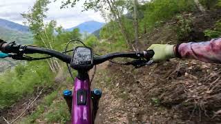
Surrounded by Bietschhorn, Weisshorn and many other peaks the tour from Giw to Visp is an absolute enduro highlight. Full of turns and challenging at times, then slow and comfortable or flowing – the 1200 m downhill has everything an enduro trail is expected to have.
Surface:
Paved: 3km
Forest Track: 4km
SingleTrail: 5km
We hope you've been enjoying Trailforks!
Create a FREE account to view route comments and much more.
| 1,224 ft | |||||
| 2,169 ft | |||||
| 574 ft | |||||
| 531 ft | |||||
| 1,529 ft | |||||
| 2,329 ft | |||||
| 2,972 ft | |||||
| 4,898 ft | |||||
| 2 miles |

Service Road Atlas is a free to use, community-driven service for viewing and creating reports on the numerous back-country service roads around B.C. and Alberta.
Save the current map location and zoom level as your default home location whenever this page is loaded.
Save