13.2 miles
Distance
2,196 ft
Climb
-2,195 ft
Descent
1,624 ft
High Point
92 ft
Altitude min
92 ft
Altitude start
92 ft
Altitude end
-59.9%
Grade max
55.8%
Grade min
6 miles
Distance climb
6 miles
Distance down
1 mile
Distance flat

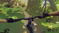
Here's a route which will offer a flavour of the Chuckanuts whilst staying away from the black diamonds.

With all the climbing on green circle trails, be prepared for some steep gradient, but it's not too technical.

Ensure that you pay Raptor Lookout a visit; it's just to the left when Huckleberry Trail meets Raptor Ridge.

Detailed Description
Green & Blue Chuckanuts is a 13 mile moderately popular intermediate route located near Bellingham Washington. This mountain bike only route can be used one direction and has a moderate overall physical rating. This route includes 26 trails. This route climbs 2,196 ft with a max elevation of 1,624 ft then descends -2,195 ft.

Trail Issues on Route

  • Minor Issue / Yellow: 3 trails (newest: Jun 12, 2026)
Local Trail Association
Local trail association
Whatcom Mountain Bike Coalition (wmbcmtb.org)
Please consider joining or donating to the local riding association to support trail development & maintenance.
Donate to earn trail karma!

Stats

  • Distance
    13 miles
  • Avg time
    4 hr 27 min
  • Altitude min
    92 ft
  • Altitude start
    92 ft
  • Altitude end
    92 ft
  • Climb
    2,196 ft
  • Descent
    -2,195 ft
  • Grade max
    -59.9%
  • Grade min
    55.8%
  • Distance climb
    6 miles
  • Distance down
    6 miles
  • Distance flat
    1 mile

31 Reviews & Comments


We hope you've been enjoying Trailforks!

Create a FREE account to view route comments and much more.

Details

  • Riding area
  • Primary Activity
    Mountain Bike
  • Difficulty rating
    Blue
  • Route Type
    Loop
  • Bike type
    AM, XC
  • Direction
    One Direction
  • Physical rating
    Moderate
  • Ridelogs
    4
no votes yet
close
3D
Trail Conditions
  • Unknown
  • Snow Groomed
  • Snow Packed
  • Snow Covered
  • Snow Cover Partial
  • Freeze/thaw Cycle
  • Icy
  • Prevalent Mud
  • Wet
  • Variable
  • Ideal
  • Dry
  • Very Dry
Trail Flow (Ridden Direction)
Trailforks scans users ridelogs to determine the most popular direction each trail is ridden. A good flowing trail network will have most trails flowing in a single direction according to their intension.
The colour categories are based on what percentage of riders are riding a trail in its intended direction.
  • > 96%
  • > 90%
  • > 80%
  • > 70%
  • > 50%
  • < 50%
  • bi-directional trail
  • no data
Trail Last Ridden
Trailforks scans ridelogs to determine the last time a trail was ridden.
  • < 2 days
  • < 1 week
  • < 2 weeks
  • < 1 month
  • < 6 months
  • > 6 months
Trail Ridden Direction
The intended direction a trail should be ridden.
  • Downhill Only
  • Downhill Primary
  • Both Directions
  • Uphill Primary
  • Uphill Only
  • One Direction
Contribute Details
Colors indicate trail is missing specified detail.
  • Description
  • Photos
  • Description & Photos
  • Videos
Trail Popularity ?
Trailforks scans ridelogs to determine which trails are ridden the most in the last 9 months. Trails are compared with nearby trails in the same city region with a possible 25 colour shades. Think of this as a heatmap, more rides = more kinetic energy = warmer colors.
  • most popular
  • popular
  • less popular
  • not popular
ATV/ORV/OHV Filter
Max Vehicle Width
inches
US Cell Coverage
Legend
cell carrier legend

Radar Time
Activity Recordings
Trailforks uses anonymized public activity data. ?
Activity Recordings
Trailforks uses anonymized public activity data. ?
Personal Heatmap
Activity Types
all / none
Options
2
Date range month
Winter Trails
Warning A routing network for winter maps does not exist. Selecting trails using the winter trails layer has been disabled.
Missing Trails
Most Popular
Least Popular
Trails are colored based on popularity. The more popular a trail is, the more red. Less popular trails trend towards green.
Jump Magnitude Heatmap
Heatmap of where riders jump on trails. Zoom in to see individual jumps, click circles to view jump details.
BC Backroad Status

Service Road Atlas is a free to use, community-driven service for viewing and creating reports on the numerous back-country service roads around B.C. and Alberta.

map legend
Slope Aspect
Direction the slope faces
Flat N NE E SE S SW W NW
Trails Deemphasized
Trails are shown in grey.
disable
Only show trails with no bike usage.
Enable
Suggested Layers
Based on selected activity type

    Save the current map location and zoom level as your default home location whenever this page is loaded.

    Save
    Trail transparency
    • Singletrack
    • Unpaved
    564
    363 | 2 comments | 1 faves
    561
    740
    Two dollar
    Two dollar
    trail: Two Dollar
    0:39 | 478 | comments: 0 | favs:
    Oct 30, 2022
    What it would look like if you rode in cartoons
    What it would look like if you rode in cartoons
    0:52 | 44 | comments: 0 | favs:
    Nov 11, 2019

    Recent Trail Reports Along Route

    statustraildateconditiondescription
    Raptor Ridge
    Jun 12, 2026 @ 9:08am (America/Los_Angeles)
    Jun 12, 2026
    Large tree down across trail, blocking trail. 100m from intersection with Lost Lake Trail 3 You need to throw bike over log to pass.
    Fragrance lake Trail Two
    May 27, 2026 @ 4:33pm (America/Los_Angeles)
    May 27, 2026
    Mint condition.
    Hemlock
    May 6, 2026 @ 12:11pm (America/Los_Angeles)
    May 6, 2026
    Huckleberry Point
    May 6, 2026 @ 12:09pm (America/Los_Angeles)
    May 6, 2026
    Lost Lake Trail North
    Apr 23, 2026 @ 1:58pm (America/Los_Angeles)
    Apr 23, 2026
    more reports »
    • By rshelmerdineTF Pro & contributors
    • #8665 - 3,831 views

    Hit the Trail

    Open in App

    Get this route on your phone instantly.

    Download Route

    Save to wishlist, Garmin & download.