
Open in App
Get this route on your phone instantly.
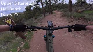
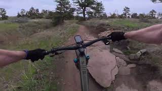
This is an great alternative if you're not up to the black diamond Lower Bitterbrush challenge. It's primarily uphill all the way to the top of Nelson Loop, then almost all downhill flow and intermediate rocks back to the parking lot. Suggest riding Nelson Loop clockwise, providing a shorter, steeper climb to the top, with a longer downhill experience. For more of a workout, you can do more than one loop around Nelson Loop. This ride is rated blue for technical rocks & roots and moderate climbing.
The Antelope parking lot is very small and there's no parking on the road, so starting in Lyons and riding to the trailhead makes for a stress-free warm-up. Start up Antelope, and climb to the top of Lower Bitterbrush. Next, head right on Upper Bitterbrush. Now you are at Nelson Loop. Take a lap (or three) then head back down Upper Bitterbrush and Antelope.
We hope you've been enjoying Trailforks!
Create a FREE account to view route comments and much more.
| 4,921 ft | |||||
| 1 mile | |||||
| 2 miles | |||||
| 1 mile | |||||
| 4,921 ft |

Service Road Atlas is a free to use, community-driven service for viewing and creating reports on the numerous back-country service roads around B.C. and Alberta.
Save the current map location and zoom level as your default home location whenever this page is loaded.
Save| status | trail | date | condition | description |
|---|---|---|---|---|
Jun 10, 2026 @ 6:03pm (America/Denver) Jun 10, 2026 | ||||
Jun 10, 2026 @ 6:03pm (America/Denver) Jun 10, 2026 | ||||
Jun 10, 2026 @ 6:03pm (America/Denver) Jun 10, 2026 |