
Open in App
Get this route on your phone instantly.
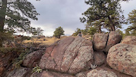
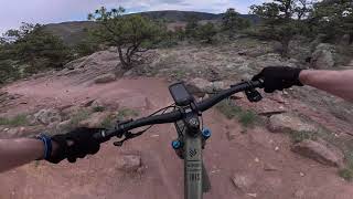
Tackling Hall Ranch up Lower Bitterbrush aka "The Rock Garden" bumps this intermediate/advanced area into solid double black. Lower Bitterbrush is only 2 miles long but it feel farther with the elevation gain, advanced technical rock features, and climbing steepness.
Start at the Bitterbrush parking lot and head up the trail. It starts out nice enough with a winding dirt track but soon the rocks come. They start out small, but get bigger and gnarlier as the trail goes on. Much of the challenge is finding the power to move through several big features back to back. The most technical section is only about a mile long, then it mellows out to the intersection with Antelope. Take a left on Upper Bitterbrush and climb to the Nelson loop. The preferred direction on Nelson is clockwise for a steeper/quicker climb and a longer, flowier descent. Come back down Upper Bitterbrush, then make a right to hit Lower Bitterbrush. Now you have a chunky, technical downhill trail you worked darn hard for so make it count
We hope you've been enjoying Trailforks!
Create a FREE account to view route comments and much more.
| 564 ft | |||||
| 1 mile | |||||
| 2 miles | |||||
| 1 mile | |||||
| 2 miles | |||||
| 630 ft |

Service Road Atlas is a free to use, community-driven service for viewing and creating reports on the numerous back-country service roads around B.C. and Alberta.
Save the current map location and zoom level as your default home location whenever this page is loaded.
Save