8.0 miles
Distance
1,059 ft
Climb
-1,060 ft
Descent
5,218 ft
High Point
0 ft
Altitude change
4,461 ft
Altitude min
4,465 ft
Altitude start
4,465 ft
Altitude end
-56.2%
Grade max
37.5%
Grade min
4 miles
Distance climb
3 miles
Distance down
2,953 ft
Distance flat

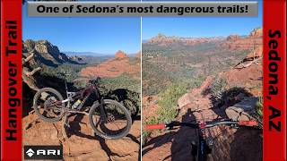
We do not recommend this trail if you are less than an advanced rider or are nervous with heights as there are some incredibly challenging sections with exposure.

This is the hardest trail in Sedona. Expect super challenging and steep climbs, huge exposure, incredible view and descents that are puckering for all levels of riders. That being said, if you are an expert level rider you should ride this trail while in Sedona. Use your common sense and walk any sections that scare you. The trail is completely ride-able for high skilled riders, it is just that if you make a mistake the consequences could be high in a couple of spots.

We suggest that you ride up the Schnebly Hill Road (rather than up on the Munds Wagon trail). Trail forks shows the start of the ride going up on Munds, but it forced that route on us... ignore that first bit and just climb up the jeep road all the way to the trail head for Hangover, once out of Hangover descend down Munds back to your starting point.

For a totally epic version of this ride we suggest the following: Start at Over the Edge bikes, climb part way up to the airport, descend Brewer, then climb up to this Hangover route as we have shown it. (If you feel done here you can just ride back after Hangover - for the full epic version do the following): Next ride Huckaby, then climb up Wilson Canyon to Jim Thompson and descend down Javelina... this is an awesome ride of close to 40km and 800 ish meters of climbing and 4-7+ hours of riding.

Detailed Description
Hangover Route is a highly rated 8 mile popular extreme route located near Sedona Arizona. This mountain bike only route can be used one direction and has a hard overall physical rating. This route includes 6 trails. This route climbs 1,059 ft with a max elevation of 5,218 ft then descends -1,060 ft.

Trail Issues on Route

  • Significant Issue / Amber: 2 trails (newest: May 3, 2026)
Local Trail Association
Local trail association
Sedona Red Rock Trail Fund (redrocktrailfund.org)
Please consider joining or donating to the local riding association to support trail development & maintenance.
Donate to earn trail karma!

Stats

  • Distance
    8 miles
  • Avg time
    1 hr 47 min
  • Altitude min
    4,461 ft
  • Altitude start
    4,465 ft
  • Altitude end
    4,465 ft
  • Climb
    1,059 ft
  • Descent
    -1,060 ft
  • Grade max
    -56.2%
  • Grade min
    37.5%
  • Distance climb
    4 miles
  • Distance down
    3 miles
  • Distance flat
    2,953 ft

35 Reviews & Comments


We hope you've been enjoying Trailforks!

Create a FREE account to view route comments and much more.

Trails in Route

Details

  • Primary Activity
    Mountain Bike
  • Difficulty rating
    Double Black Diamond
  • Route Type
    Loop
  • eBike Allowed
  • Bike type
    AM
  • Direction
    One Direction
  • Physical rating
    Hard
  • Ridelogs
    550
Avg: 4 (8 votes)
close
3D
Trail Conditions
  • Unknown
  • Snow Groomed
  • Snow Packed
  • Snow Covered
  • Snow Cover Partial
  • Freeze/thaw Cycle
  • Icy
  • Prevalent Mud
  • Wet
  • Variable
  • Ideal
  • Dry
  • Very Dry
Trail Flow (Ridden Direction)
Trailforks scans users ridelogs to determine the most popular direction each trail is ridden. A good flowing trail network will have most trails flowing in a single direction according to their intension.
The colour categories are based on what percentage of riders are riding a trail in its intended direction.
  • > 96%
  • > 90%
  • > 80%
  • > 70%
  • > 50%
  • < 50%
  • bi-directional trail
  • no data
Trail Last Ridden
Trailforks scans ridelogs to determine the last time a trail was ridden.
  • < 2 days
  • < 1 week
  • < 2 weeks
  • < 1 month
  • < 6 months
  • > 6 months
Trail Ridden Direction
The intended direction a trail should be ridden.
  • Downhill Only
  • Downhill Primary
  • Both Directions
  • Uphill Primary
  • Uphill Only
  • One Direction
Contribute Details
Colors indicate trail is missing specified detail.
  • Description
  • Photos
  • Description & Photos
  • Videos
Trail Popularity ?
Trailforks scans ridelogs to determine which trails are ridden the most in the last 9 months. Trails are compared with nearby trails in the same city region with a possible 25 colour shades. Think of this as a heatmap, more rides = more kinetic energy = warmer colors.
  • most popular
  • popular
  • less popular
  • not popular
ATV/ORV/OHV Filter
Max Vehicle Width
inches
US Cell Coverage
Legend
cell carrier legend

Radar Time
Activity Recordings
Trailforks uses anonymized public activity data. ?
Activity Recordings
Trailforks uses anonymized public activity data. ?
Personal Heatmap
Activity Types
all / none
Options
2
Date range month
Winter Trails
Warning A routing network for winter maps does not exist. Selecting trails using the winter trails layer has been disabled.
Missing Trails
Most Popular
Least Popular
Trails are colored based on popularity. The more popular a trail is, the more red. Less popular trails trend towards green.
Jump Magnitude Heatmap
Heatmap of where riders jump on trails. Zoom in to see individual jumps, click circles to view jump details.
BC Backroad Status

Service Road Atlas is a free to use, community-driven service for viewing and creating reports on the numerous back-country service roads around B.C. and Alberta.

map legend
Slope Aspect
Direction the slope faces
Flat N NE E SE S SW W NW
Trails Deemphasized
Trails are shown in grey.
disable
Only show trails with no bike usage.
Enable
Suggested Layers
Based on selected activity type

    Save the current map location and zoom level as your default home location whenever this page is loaded.

    Save
    Trail transparency
    • Singletrack
    • Unpaved
    1,297
    685
    967
    397
    Sedona Trail Guide: Hangover
    Sedona Trail Guide: Hangover
    14:29 | 14 | comments: 0 | favs:
    Apr 28, 2026

    Recent Trail Reports Along Route

    statustraildateconditiondescription
    Hangover
    May 3, 2026 @ 5:57pm (America/Phoenix)
    May 3, 2026
    trail eroded and fld up with ruts, roots and washed out sections, its getting worse and worse
    Munds Wagon
    Apr 8, 2026 @ 12:07pm (America/Phoenix)
    Apr 8, 2026
    Large tree down. Needs chainsaw. This trail has been really neglected. Needs an overhaul. With good rock armouring. In many areas.
    Schnebly Hill Road
    Sep 12, 2025 @ 9:47am (America/Phoenix)
    Sep 12, 2025
    more reports »
    • By caradock & contributors
    • #1886 - 12,051 views

    Hit the Trail

    Open in App

    Get this route on your phone instantly.

    Download Route

    Save to wishlist, Garmin & download.