11.3 miles
Distance
1,540 ft
Climb
-1,536 ft
Descent
2 miles
High Point
4 ft
Altitude change
8,282 ft
Altitude min
8,660 ft
Altitude start
8,665 ft
Altitude end
-33.8%
Grade max
30.1%
Grade min
5 miles
Distance climb
5 miles
Distance down
5,210 ft
Distance flat

This routes takes riders through what I would consider to be the best trails that Happy Jack Area has to offer. Although not a long ride, this is not for the faint of heart. If the elevation (all above 8,300') doesn't get you, the steep, technical climbing might. Once it's all over, however, you'll be begging for more

Start this ride from the USFS day-use parking area. Head north on Headquarters trail, which will immediately connect you to a three-way intersection. Stay left here and veer onto Upper UW Loop and then stay left again to continue on the western portion of the loop. Upper UW is a wide nordic track that provides fast, easy riding for mountain bikes.

Turn right at an intersection with Meadow Trail and Ridge Trail, then stay straight (straight on Lower UW Trail, too) to hop onto your first fun descent, Aspen Trail. Aspen Trail quickly departs Lower UW Trail and bombs over roots and streams as it winds its way down an undulating hillside. With this undulation comes a couple short uphill bursts, but you should be able to smash right through them.

At the bottom of Aspen Trail (where an appropriately placed aspen grove lives), turn right onto Aspen Trail Connector. This short trail connects you to what I would consider to be the hardest uphill of this ride, Haunted Forest Trail. Haunted Forest brings you up a very steep trail complete with multiple root and rock step-ups. And as if it wasn't hard enough, the trail is an ephemeral creek in the Springtime.

Take this trail all the way to a four-way intersection with Summit Trail and a short connector. Turn left onto Summit Trail and follow that for a short distance to Summit Loop. Turn left onto the Summit Loop climb. This brings you to the ride's highpoint and IMO the best descent, Death Crotch.

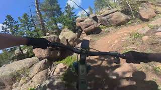
From the onset, you know you're in for it when you start Death Crotch. The trail immediately climbs loosely from Summit Loop and then violently drops you through a technical rock garden. After a little more descending, this "descent" treats you with its first surprise, a very steep and loose uphill. Luckily, this is the last up on this trail, and the rest is an all-out blast, technical fun-fest.

From its finish, turn immediately right onto Hooch Trail, which is a climb into a wide descent bringing you over a creek. Continue south here on USFS #707, all the way to the Headquarters parking area. This is a great spot to stop and eat a well-earned snack as there's a picnic table at the TH.

From your snack spot, head uphill on the very rideable and actually quite fun Headquarters trail. This trail brings you up not-too-technical rock gardens and has some not-too-tight switchbacks to ride. Eventually, after much struggling, you'll reach an intersection with Browns Landing. Stay right here onto Headquarters and blast through the tight woods. Continue past the Summit Loop (twice) and head past Double Black Diamond, which will appear on your left.

Finally, turn left onto the Headquarters Overlook trail. This is the perfect lunch spot as it has incredible panoramic views across I-80 to the mountains in both Colorado and Wyoming. From here, you'll be able to see the Never Summers, the Rahwahs, the Medicine Bows, the Mummy Range, and the Snowy Range.

After you've soaked up the view, continue west on Headquarters and avoiding any of the three trail junctions you'll come across, a final left turn on HQ will drop you back to the parking lot and the cold beers you've got stashed in a cooler.
History & Background
Just north of Aspen Trail lies the old Happy Jack ski area. It operated two t-bar lifts from 1963 to 1977.

Detailed Description
Happy Jacked is a 11 mile moderately popular expert route located near Laramie Wyoming. This mountain bike only route can be used one direction and has a hard overall physical rating. This route includes 17 trails. This route climbs 1,540 ft with a max elevation of 8,944 ft then descends -1,536 ft.
Local Trail Association
Local trail association
Laramie BikeNet (www.laramiebikenet.org)
Please consider joining or donating to the local riding association to support trail development & maintenance.
Donate to earn trail karma!

Stats

  • Distance
    11 miles
  • Avg time
    2 hr 57 min
  • Altitude min
    8,282 ft
  • Altitude start
    8,660 ft
  • Altitude end
    8,665 ft
  • Climb
    1,540 ft
  • Descent
    -1,536 ft
  • Grade max
    -33.8%
  • Grade min
    30.1%
  • Distance climb
    5 miles
  • Distance down
    5 miles
  • Distance flat
    5,210 ft

20 Reviews & Comments


We hope you've been enjoying Trailforks!

Create a FREE account to view route comments and much more.

Details

  • Riding area
  • Primary Activity
    Mountain Bike
  • Difficulty rating
    Black Diamond
  • Route Type
    Loop
  • eBike Allowed
  • Bike type
    AM
  • Direction
    One Direction
  • Physical rating
    Hard
no votes yet
close
3D
Trail Conditions
  • Unknown
  • Snow Groomed
  • Snow Packed
  • Snow Covered
  • Snow Cover Partial
  • Freeze/thaw Cycle
  • Icy
  • Prevalent Mud
  • Wet
  • Variable
  • Ideal
  • Dry
  • Very Dry
Trail Flow (Ridden Direction)
Trailforks scans users ridelogs to determine the most popular direction each trail is ridden. A good flowing trail network will have most trails flowing in a single direction according to their intension.
The colour categories are based on what percentage of riders are riding a trail in its intended direction.
  • > 96%
  • > 90%
  • > 80%
  • > 70%
  • > 50%
  • < 50%
  • bi-directional trail
  • no data
Trail Last Ridden
Trailforks scans ridelogs to determine the last time a trail was ridden.
  • < 2 days
  • < 1 week
  • < 2 weeks
  • < 1 month
  • < 6 months
  • > 6 months
Trail Ridden Direction
The intended direction a trail should be ridden.
  • Downhill Only
  • Downhill Primary
  • Both Directions
  • Uphill Primary
  • Uphill Only
  • One Direction
Contribute Details
Colors indicate trail is missing specified detail.
  • Description
  • Photos
  • Description & Photos
  • Videos
Trail Popularity ?
Trailforks scans ridelogs to determine which trails are ridden the most in the last 9 months. Trails are compared with nearby trails in the same city region with a possible 25 colour shades. Think of this as a heatmap, more rides = more kinetic energy = warmer colors.
  • most popular
  • popular
  • less popular
  • not popular
ATV/ORV/OHV Filter
Max Vehicle Width
inches
US Cell Coverage
Legend
cell carrier legend

Radar Time
Activity Recordings
Trailforks uses anonymized public activity data. ?
Activity Recordings
Trailforks uses anonymized public activity data. ?
Personal Heatmap
Activity Types
all / none
Options
2
Date range month
Winter Trails
Warning A routing network for winter maps does not exist. Selecting trails using the winter trails layer has been disabled.
Missing Trails
Most Popular
Least Popular
Trails are colored based on popularity. The more popular a trail is, the more red. Less popular trails trend towards green.
Jump Magnitude Heatmap
Heatmap of where riders jump on trails. Zoom in to see individual jumps, click circles to view jump details.
BC Backroad Status

Service Road Atlas is a free to use, community-driven service for viewing and creating reports on the numerous back-country service roads around B.C. and Alberta.

map legend
Slope Aspect
Direction the slope faces
Flat N NE E SE S SW W NW
Trails Deemphasized
Trails are shown in grey.
disable
Only show trails with no bike usage.
Enable
Suggested Layers
Based on selected activity type

    Save the current map location and zoom level as your default home location whenever this page is loaded.

    Save
    Trail transparency
    • Singletrack
    • Unpaved
    137
    251
    301
    736
    Aspen
    Aspen
    trail: Aspen
    11:53 | 105 | comments: 0 | favs:
    Jul 2, 2025
    Headquarters NRT
    Headquarters NRT
    11:16 | 99 | comments: 0 | favs:
    Jul 2, 2025

    Recent Trail Reports Along Route

    statustraildateconditiondescription
    Headquarters Overlook
    Jun 11, 2026 @ 12:51pm (America/Denver)
    Jun 11, 2026
    Headquarters NRT
    Jun 11, 2026 @ 12:51pm (America/Denver)
    Jun 11, 2026
    Aspen
    Jun 11, 2026 @ 12:51pm (America/Denver)
    Jun 11, 2026
    Lower UW
    Jun 11, 2026 @ 12:51pm (America/Denver)
    Jun 11, 2026
    Death Crotch
    Nov 10, 2025 @ 1:56pm (America/Denver)
    Nov 10, 2025
    more reports »
    • By PopoMackTF Pro & contributors
    • #9680 - 2,469 views

    Hit the Trail

    Open in App

    Get this route on your phone instantly.

    Download Route

    Save to wishlist, Garmin & download.