3.0 miles
Distance
636 ft
Climb
-621 ft
Descent
4,029 ft
High Point
13 ft
Altitude change
3,392 ft
Altitude min
3,392 ft
Altitude start
3,406 ft
Altitude end
0.1%
Grade
-48.2%
Grade max
31.1%
Grade min
2 miles
Distance climb
1 mile
Distance down
620 ft
Distance flat

How to find it
Either ride straight onto it if you've just come down S Bomb - it's on the opposite side of the powerline road. If you are looking to ride up it, then through Fernie Provincial Park campsite, onto the Island lake Road and down the first section of gravel road, as the road swings left, you will see the trail on the right. Ride in on this for about 50m and then turn left and up.
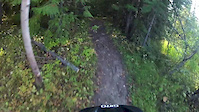
The trail
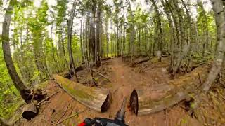
Used to be full of big stunts, log rides and jumps. Most of the stunts have now been deactivated because they have become dilapidated. Be careful about riding out onto any wodden structures. It's now an awesome climb and has become part of a popular circuit - up Hedonism, cross the powerline, up the first section of S Bomb and then down Brokeback.

Detailed Description
Hedonism Lap is a 3 mile popular intermediate route located near Fernie British Columbia. This mountain bike only route can be used one direction and has a moderate overall physical rating. This route includes 6 trails. This route climbs 636 ft with a max elevation of 4,029 ft then descends -621 ft.

Trail Issues on Route

  • Significant Issue / Amber: 2 trails (newest: Mar 30, 2026)
Route Supporters
Local Trail Association
Local trail association
Fernie Trails Alliance (www.fernietrailsalliance.com)
Please consider joining or donating to the local riding association to support trail development & maintenance.
Donate to earn trail karma!

Stats

  • Distance
    3 miles
  • Avg time
    52 min 38 sec
  • Altitude min
    3,392 ft
  • Altitude start
    3,392 ft
  • Altitude end
    3,406 ft
  • Climb
    636 ft
  • Descent
    -621 ft
  • Grade
    0.1%
  • Grade max
    -48.2%
  • Grade min
    31.1%
  • Distance climb
    2 miles
  • Distance down
    1 mile
  • Distance flat
    620 ft

11 Reviews & Comments


We hope you've been enjoying Trailforks!

Create a FREE account to view route comments and much more.

Details

  • Riding area
  • Primary Activity
    Mountain Bike
  • Difficulty rating
    Blue
  • Route Type
    Loop
  • Bike type
    AM
  • Direction
    One Direction
  • Physical rating
    Moderate
  • Ridelogs
    15
Avg: 4.35 (5 votes)
close
3D
Trail Conditions
  • Unknown
  • Snow Groomed
  • Snow Packed
  • Snow Covered
  • Snow Cover Partial
  • Freeze/thaw Cycle
  • Icy
  • Prevalent Mud
  • Wet
  • Variable
  • Ideal
  • Dry
  • Very Dry
Trail Flow (Ridden Direction)
Trailforks scans users ridelogs to determine the most popular direction each trail is ridden. A good flowing trail network will have most trails flowing in a single direction according to their intension.
The colour categories are based on what percentage of riders are riding a trail in its intended direction.
  • > 96%
  • > 90%
  • > 80%
  • > 70%
  • > 50%
  • < 50%
  • bi-directional trail
  • no data
Trail Last Ridden
Trailforks scans ridelogs to determine the last time a trail was ridden.
  • < 2 days
  • < 1 week
  • < 2 weeks
  • < 1 month
  • < 6 months
  • > 6 months
Trail Ridden Direction
The intended direction a trail should be ridden.
  • Downhill Only
  • Downhill Primary
  • Both Directions
  • Uphill Primary
  • Uphill Only
  • One Direction
Contribute Details
Colors indicate trail is missing specified detail.
  • Description
  • Photos
  • Description & Photos
  • Videos
Trail Popularity ?
Trailforks scans ridelogs to determine which trails are ridden the most in the last 9 months. Trails are compared with nearby trails in the same city region with a possible 25 colour shades. Think of this as a heatmap, more rides = more kinetic energy = warmer colors.
  • most popular
  • popular
  • less popular
  • not popular
ATV/ORV/OHV Filter
Max Vehicle Width
inches
US Cell Coverage
Legend
cell carrier legend

Radar Time
Activity Recordings
Trailforks uses anonymized public activity data. ?
Activity Recordings
Trailforks uses anonymized public activity data. ?
Personal Heatmap
Activity Types
all / none
Options
2
Date range month
Winter Trails
Warning A routing network for winter maps does not exist. Selecting trails using the winter trails layer has been disabled.
Missing Trails
Most Popular
Least Popular
Trails are colored based on popularity. The more popular a trail is, the more red. Less popular trails trend towards green.
Jump Magnitude Heatmap
Heatmap of where riders jump on trails. Zoom in to see individual jumps, click circles to view jump details.
BC Backroad Status

Service Road Atlas is a free to use, community-driven service for viewing and creating reports on the numerous back-country service roads around B.C. and Alberta.

map legend
Slope Aspect
Direction the slope faces
Flat N NE E SE S SW W NW
Trails Deemphasized
Trails are shown in grey.
disable
Only show trails with no bike usage.
Enable
Suggested Layers
Based on selected activity type

    Save the current map location and zoom level as your default home location whenever this page is loaded.

    Save
    Trail transparency
    • Singletrack
    • Unpaved
    • Paved
    58
    56
    52
    45
    Hedonism, Fernie BC.
    Hedonism, Fernie BC.
    trail: Hedonism
    5:06 | 183 | comments: 0 | favs:
    Jun 6, 2024
    Fernie Mtn Biking
    Fernie Mtn Biking
    trail: Hedonism
    4:10 | 685 | comments: 0 | favs:
    Oct 2, 2012
    Hedonism

    Recent Trail Reports Along Route

    statustraildateconditiondescription
    Stove Trail
    Jun 17, 2026 @ 7:40am (America/Creston)
    1 day
    reporter
    Hedonism
    May 2, 2026 @ 2:43pm (America/Edmonton)
    May 2, 2026
    a few metres of mud in the beginning but bone dry after that.
    Powerline Road
    Mar 30, 2026 @ 2:15pm (America/Edmonton)
    Mar 30, 2026
    Trail is snow covered, but ground is no longer as firm as in winter. Use caution as snow melts as riding when soft can cause trail damage.
    Hedonism / Stove Connector
    Mar 30, 2026 @ 11:46am (America/Edmonton)
    Mar 30, 2026
    Campsite Road 2
    Mar 28, 2026 @ 1:56pm (America/Edmonton)
    Mar 28, 2026
    more reports »
    • By FernieBC & contributors
    • #2257 - 2,762 views

    Hit the Trail

    Open in App

    Get this route on your phone instantly.

    Download Route

    Save to wishlist, Garmin & download.