8.4 miles
Distance
1,028 ft
Climb
-1,025 ft
Descent
1 mile
High Point
3 ft
Altitude change
5,896 ft
Altitude min
5,896 ft
Altitude start
5,899 ft
Altitude end
-19.9%
Grade max
27.5%
Grade min
4 miles
Distance climb
4 miles
Distance down
1,119 ft
Distance flat

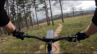
A fun ride through the fastest and most technical parts of Heil Ranch.

From the main parking lot climb the gravel road to the start of the Wapiti singletrack. The chunky, slightly technical climb will get your heart rate up but flow can be found through the many baby heads and angular slabs of sandstone. Once at the top of Wapiti head left to start the Ponderosa loop. After 10 minutes the trail will level out and turn downhill. Get ready for a fast flowing descent with armored berms and fast rollers. Enjoy the view of Hall Ranch from the bench and turn right to finish the Ponderosa loop via a 15 minute climb back to where you started.

Despite being quite chunky and rocky (some even call this trail "rude," but it just takes a while to get to know), the descent down Wapiti is fast and fun. Watch out for hikers and mountain bikers climbing Wapiti, although it's fast it is a bi-directional, multi-use trail.

Detailed Description
Heil Ranch, frontside is a 8 mile popular intermediate route located near Lyons Colorado. This mountain bike primary route can be used one direction and has a moderate overall physical rating. This route includes 4 trails. This route climbs 1,028 ft with a max elevation of 6,806 ft then descends -1,025 ft.
Local Trail Association
Local trail association
Boulder Mountainbike Alliance (bouldermountainbike.org)
Please consider joining or donating to the local riding association to support trail development & maintenance.
Donate to earn trail karma!

Stats

  • Distance
    8 miles
  • Avg time
    1 hr 57 min
  • Altitude min
    5,896 ft
  • Altitude start
    5,896 ft
  • Altitude end
    5,899 ft
  • Climb
    1,028 ft
  • Descent
    -1,025 ft
  • Grade max
    -19.9%
  • Grade min
    27.5%
  • Distance climb
    4 miles
  • Distance down
    4 miles
  • Distance flat
    1,119 ft

5 Reviews & Comments


We hope you've been enjoying Trailforks!

Create a FREE account to view route comments and much more.

Trails in Route

Wapiti2 miles
Wapiti2 miles
Wapiti Road4,301 ft

Details

  • Featured
  • Riding area
  • Primary Activity
    Mountain Bike
  • Other Activities
    • Hike
    • Trail Running
  • Difficulty rating
    Blue
  • Route Type
    Out & Back
  • eBike Allowed
  • Bike type
    AM, XC
  • Direction
    One Direction
  • Physical rating
    Moderate
  • Ridelogs
    615

Directions

  1. Bike north on Wapiti Road.
  2. Continue for 1.5 kilometers.
  3. Bike north on Wapiti Road.
  4. Continue for 2 kilometers.
  5. Bike northeast on Wapiti.
  6. Continue for 1.5 kilometers.
  7. Bike northwest on Ponderosa Loop.
  8. Continue for 2.5 kilometers.
  9. Bike northeast on Ponderosa Loop.
  10. Continue for 1.5 kilometers.
  11. Bike south on Ponderosa Loop.
  12. Continue for less than 10 meters.
  13. Turn right to stay on Ponderosa Loop.
  14. Continue for 200 meters.
  15. Bike southwest on Ponderosa Loop.
  16. Continue for 40 meters.
  17. Turn left onto Wapiti.
  18. Continue for 2 kilometers.
  19. Bike southwest on Wapiti.
  20. Continue for 1.5 kilometers.
  21. Bike southeast on Wapiti Road.
  22. Continue for 1.5 kilometers.
Avg: 3 (1 votes)
close
3D
Trail Conditions
  • Unknown
  • Snow Groomed
  • Snow Packed
  • Snow Covered
  • Snow Cover Partial
  • Freeze/thaw Cycle
  • Icy
  • Prevalent Mud
  • Wet
  • Variable
  • Ideal
  • Dry
  • Very Dry
Trail Flow (Ridden Direction)
Trailforks scans users ridelogs to determine the most popular direction each trail is ridden. A good flowing trail network will have most trails flowing in a single direction according to their intension.
The colour categories are based on what percentage of riders are riding a trail in its intended direction.
  • > 96%
  • > 90%
  • > 80%
  • > 70%
  • > 50%
  • < 50%
  • bi-directional trail
  • no data
Trail Last Ridden
Trailforks scans ridelogs to determine the last time a trail was ridden.
  • < 2 days
  • < 1 week
  • < 2 weeks
  • < 1 month
  • < 6 months
  • > 6 months
Trail Ridden Direction
The intended direction a trail should be ridden.
  • Downhill Only
  • Downhill Primary
  • Both Directions
  • Uphill Primary
  • Uphill Only
  • One Direction
Contribute Details
Colors indicate trail is missing specified detail.
  • Description
  • Photos
  • Description & Photos
  • Videos
Trail Popularity ?
Trailforks scans ridelogs to determine which trails are ridden the most in the last 9 months. Trails are compared with nearby trails in the same city region with a possible 25 colour shades. Think of this as a heatmap, more rides = more kinetic energy = warmer colors.
  • most popular
  • popular
  • less popular
  • not popular
ATV/ORV/OHV Filter
Max Vehicle Width
inches
US Cell Coverage
Legend
cell carrier legend

Radar Time
Activity Recordings
Trailforks uses anonymized public activity data. ?
Activity Recordings
Trailforks uses anonymized public activity data. ?
Personal Heatmap
Activity Types
all / none
Options
2
Date range month
Winter Trails
Warning A routing network for winter maps does not exist. Selecting trails using the winter trails layer has been disabled.
Missing Trails
Most Popular
Least Popular
Trails are colored based on popularity. The more popular a trail is, the more red. Less popular trails trend towards green.
Jump Magnitude Heatmap
Heatmap of where riders jump on trails. Zoom in to see individual jumps, click circles to view jump details.
BC Backroad Status

Service Road Atlas is a free to use, community-driven service for viewing and creating reports on the numerous back-country service roads around B.C. and Alberta.

map legend
Slope Aspect
Direction the slope faces
Flat N NE E SE S SW W NW
Trails Deemphasized
Trails are shown in grey.
disable
Only show trails with no bike usage.
Enable
Suggested Layers
Based on selected activity type

    Save the current map location and zoom level as your default home location whenever this page is loaded.

    Save
    Trail transparency
    • Singletrack
    • Unpaved
    38
    21
    101 | 1 faves
    617
    Wapiti
    Wapiti
    trail: Wapiti
    10:54 | 22 | comments: 0 | favs:
    Mar 8, 2026
    Wapiti on my 2009 Project Rockhopper - Heil...
    Wapiti on my 2009 Project Rockhopper - Heil Valley Ranch - Lyons - Colorado
    trail: Wapiti
    12:42 | 169 | comments: 0 | favs:
    Sep 12, 2024

    Recent Trail Reports Along Route

    statustraildateconditiondescription
    Wapiti Road
    May 31, 2026 @ 11:33am (America/Denver)
    May 31, 2026
    Wapiti
    May 8, 2026 @ 1:20pm (America/Denver)
    May 8, 2026
    Trail is open. Please update conditions if you ride.
    Wapiti Reroute Alternate1
    Dec 24, 2025 @ 8:22am (America/Denver)
    Dec 24, 2025
    Trail is open. Please update conditions if you ride
    more reports »
    • By provin1327TF Pro & contributors
    • #7157 - 3,128 views

    Hit the Trail

    Open in App

    Get this route on your phone instantly.

    Download Route

    Save to wishlist, Garmin & download.