257.3 miles
Distance
38,781 ft
Climb
-38,757 ft
Descent
2 miles
High Point
25 ft
Altitude change
5,495 ft
Altitude min
5,805 ft
Altitude start
5,830 ft
Altitude end
-77.8%
Grade max
61.4%
Grade min
111 miles
Distance climb
111 miles
Distance down
35 miles
Distance flat

this route travels into extremely remote terrain with exposed riding at times

The Idaho Gem is a beauty of a bikepacking route traveling through four different mountain ranges in Central Idaho. Envisioned during the 2023 season, this route showcases all that the mountain biking of Central Idaho has to offer. Development of the route focused on highlighting the backcountry riding, remote nature, and stellar descents of Central Idaho. Rides can expect stunning terrain, plenty of camping options, challenging singletrack, and little pavement. Due to the technically demanding, and sometimes exposed nature of the riding, plus substantial hike-a-bikes, this route should only be attempted by competent and prepared riders.

While there are significant hike a bike sections, most of these are rewarded with an amazing backcountry descent on the other side

The window for this route is relatively short: wait for the high elevation terrain to be snow-free in July, and ride the route before the first winter storms shut it down, typically sometime in October.

Much of this route happens on multi-use motorized trails. The local Moto riding community works hard to cut out the backcountry trails each year; without their effort, these trails would be reclaimed by the nature and would be impassable for MTBs. There is a healthy relationship between the Moto community and MTB community in this area; please respect it.

The multitude of backcountry trails in the greater Sun Valley area allow for many variations and add ons; be creative and imaginative and go have a blast!

Highlights include:
- Traversing the Greenhorn trail network across Mars Ridge and the descent down the South Fork Warm Springs
- A stop at the Smoky Bar store
- South Fork Ross Fork descent
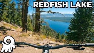
- Trip around Redfish Lake
- Stanley
- The iconic Williams Creek descent
- A stop at Galena Lodge
- An optional overnight at Coyote Yurt!
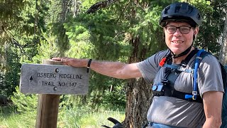
- Finishing on the all-time classic Osberg Ridge to Adams Rib back into town
- The numerous mountain lake camping options

RideWithGPS link: https://ridewithgps.com/routes/44682645

Detailed Description
Idaho Gem is a 257 mile popular expert route located near Ketchum Idaho. This mountain bike only route. This route includes 44 trails. This route climbs 38,781 ft with a max elevation of 9,752 ft then descends -38,757 ft.

Trail Issues on Route

  • Significant Issue / Amber: 13 trails (newest: May 26, 2026)
  • Minor Issue / Yellow: 8 trails (newest: Jun 7, 2026)
Local Trail Association
Please consider joining or donating to the local riding association to support trail development & maintenance.
Donate to earn trail karma!

Stats

  • Distance
    257 miles
  • Altitude change
    25 ft
  • Altitude min
    5,495 ft
  • Altitude start
    5,805 ft
  • Altitude end
    5,830 ft
  • Climb
    7 miles
  • Descent
    -38,757 ft
  • Grade max
    -77.8%
  • Grade min
    61.4%
  • Distance climb
    111 miles
  • Distance down
    111 miles
  • Distance flat
    35 miles

100 Reviews & Comments


We hope you've been enjoying Trailforks!

Create a FREE account to view route comments and much more.

Details

  • Riding area
  • Primary Activity
    Mountain Bike
  • Difficulty rating
    Black Diamond
  • Bikepacking
    Yes
Avg: 3.75 (4 votes)
close
3D
Trail Conditions
  • Unknown
  • Snow Groomed
  • Snow Packed
  • Snow Covered
  • Snow Cover Partial
  • Freeze/thaw Cycle
  • Icy
  • Prevalent Mud
  • Wet
  • Variable
  • Ideal
  • Dry
  • Very Dry
Trail Flow (Ridden Direction)
Trailforks scans users ridelogs to determine the most popular direction each trail is ridden. A good flowing trail network will have most trails flowing in a single direction according to their intension.
The colour categories are based on what percentage of riders are riding a trail in its intended direction.
  • > 96%
  • > 90%
  • > 80%
  • > 70%
  • > 50%
  • < 50%
  • bi-directional trail
  • no data
Trail Last Ridden
Trailforks scans ridelogs to determine the last time a trail was ridden.
  • < 2 days
  • < 1 week
  • < 2 weeks
  • < 1 month
  • < 6 months
  • > 6 months
Trail Ridden Direction
The intended direction a trail should be ridden.
  • Downhill Only
  • Downhill Primary
  • Both Directions
  • Uphill Primary
  • Uphill Only
  • One Direction
Contribute Details
Colors indicate trail is missing specified detail.
  • Description
  • Photos
  • Description & Photos
  • Videos
Trail Popularity ?
Trailforks scans ridelogs to determine which trails are ridden the most in the last 9 months. Trails are compared with nearby trails in the same city region with a possible 25 colour shades. Think of this as a heatmap, more rides = more kinetic energy = warmer colors.
  • most popular
  • popular
  • less popular
  • not popular
ATV/ORV/OHV Filter
Max Vehicle Width
inches
US Cell Coverage
Legend
cell carrier legend

Radar Time
Activity Recordings
Trailforks uses anonymized public activity data. ?
Activity Recordings
Trailforks uses anonymized public activity data. ?
Personal Heatmap
Activity Types
all / none
Options
2
Date range month
Winter Trails
Warning A routing network for winter maps does not exist. Selecting trails using the winter trails layer has been disabled.
Missing Trails
Most Popular
Least Popular
Trails are colored based on popularity. The more popular a trail is, the more red. Less popular trails trend towards green.
Jump Magnitude Heatmap
Heatmap of where riders jump on trails. Zoom in to see individual jumps, click circles to view jump details.
BC Backroad Status

Service Road Atlas is a free to use, community-driven service for viewing and creating reports on the numerous back-country service roads around B.C. and Alberta.

map legend
Slope Aspect
Direction the slope faces
Flat N NE E SE S SW W NW
Trails Deemphasized
Trails are shown in grey.
disable
Only show trails with no bike usage.
Enable
Suggested Layers
Based on selected activity type

    Save the current map location and zoom level as your default home location whenever this page is loaded.

    Save
    Trail transparency
    • Singletrack
    • Unpaved
    142
    107
    120
    108
    youtuber Mountain Biking Around Redfish Lake / Stanley, ID
    Mountain Biking Around Redfish Lake / Stanley, ID
    12:57 | 147 | comments: 0 | favs:
    Nov 26, 2024
    Osberg Ridgeline to Alden Gulch
    Osberg Ridgeline to Alden Gulch
    23:12 | 97 | comments: 0 | favs:
    Sep 8, 2025

    Recent Trail Reports Along Route

    statustraildateconditiondescription
    Warfield-South Fork
    Jun 15, 2026 @ 8:31pm (America/Boise)
    Jun 15, 2026
    The rest of the trail has been cut out.
    Redfish-Stanley Trail
    Jun 14, 2026 @ 5:03pm (America/Boise)
    Jun 14, 2026
    Erosion damage from last winter is mostly fixes. Plenty of soft spots where that work occurred that can catch you if you’re not paying attention.
    Harper's Trail
    Jun 11, 2026 @ 9:42pm (America/Boise)
    Jun 11, 2026
    Running nicely right now
    Baker Norton Connector
    Jun 11, 2026 @ 6:31pm (America/Boise)
    Jun 11, 2026
    Still Holding lots of snow on the north sides of the passes down to Apollo and Norton
    Red Warrior - Warfield
    Jun 9, 2026 @ 9:21pm (America/Boise)
    Jun 9, 2026
    more reports »
    • By ccmskiTF Pro & contributors
    • #55923 - 977 views

    Hit the Trail

    Open in App

    Get this route on your phone instantly.

    Download Route

    Save to wishlist, Garmin & download.