10.9 miles
Distance
694 ft
Climb
-6,887 ft
Descent
2 miles
High Point
-6,194 ft
Altitude change
1,905 ft
Altitude min
8,098 ft
Altitude start
1,906 ft
Altitude end
-10.7%
Grade
-125.4%
Grade max
22.6%
Grade min
2 miles
Distance climb
8 miles
Distance down
2,047 ft
Distance flat

| Trail Etiquette | -Hikers have the right of way -Always yield for non-bike trail users (complete stop when crossing) -Anticipate other trail users -Let other trail users know you are coming -Leave no trace

An amazing Enduro track from Chandolin to Sierre (or Leuk alternatively)
> To be able to ride this trail in the future, PLEASE NO DOWNHILL-BIKES AND NO FULL-FACE HELMETS. Thx!

1a) Take the postal bus at the main station in "Sierre" or at the 4th stop "Sierre, Bois-de-Finges" near the end of the highway (Sierre-Est). > It's highly recommended to make a RESERVATION via www.resabike.ch (until 4 p.m. the previous day).
1b) Change the bus in "Vissoie" to "Chandolin, télésiège"
2) You'll arrive directly in front of the chairlift of "Tsapé"
3) After that, a short ride from the chairlift of Tsapé to the top of Illsee pass (20 minutes)
2) Start of the trail : the first part is really steep, rocky and very technical. It ends on the barrage of Illsee (Gorgeous view at this point)
3) Then, the trail is a little less sketchy but still technical with some challenging turns.
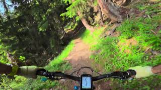
4) The entrance of the forest is just a pure pleasure ! Soft ground, great speed and magical slippery turns !

| ATTENTION | To avoid conflict with alpine herdsman and animals (cows), please RIDE SLOW when you arrive at the grazed alps "Obermäschlär & Unnermäschlär" (from 1600 m.a.s.l.). Be gentle to the animals & herdsman and DON'T LEAVE the trail.

5) Once you've reached the valley floor, you can cross the scenic "Bhutan bridge" over the Illbach river and follow a singletrack to go back to the bus stop.
6) Alternatively you can cut down to Leuk and take another bus into the south facing region of Leuk/Sonnenberge.

This route is Unsanctioned, Ride at your own Risk!

Detailed Description
Illhorn is a 11 mile popular black unsanctioned route located near Leuk. This mountain bike only route can be used one direction and has a hard overall physical rating. This route includes 11 trails. This route climbs 694 ft with a max elevation of 8,341 ft then descends -6,887 ft.

Trail Issues on Route

  • Minor Issue / Yellow: 3 trails (newest: Jun 22, 2026)

Stats

  • Distance
    11 miles
  • Avg time
    3 hr 5 min
  • Altitude change
    -6,194 ft
  • Altitude min
    1,905 ft
  • Altitude start
    8,098 ft
  • Altitude end
    1,906 ft
  • Climb
    694 ft
  • Descent
    -6,887 ft
  • Grade
    -10.7%
  • Grade max
    -125.4%
  • Grade min
    22.6%
  • Distance climb
    2 miles
  • Distance down
    8 miles
  • Distance flat
    2,047 ft

1 Review & Comments


We hope you've been enjoying Trailforks!

Create a FREE account to view route comments and much more.

Route POI

Shuttle Pick-up/Drop-offBus StopShuttle Pick-up/Drop-off
ParkingParkingParking

Details

  • Riding area
  • Primary Activity
    Mountain Bike
  • AKA
    Illsee
  • Difficulty rating
    Black
  • Route Type
    Shuttled
  • eBike Allowed
  • Bike type
    DH
  • Direction
    One Direction
  • Physical rating
    Hard
  • Ridelogs
    1
Avg: 5 (1 votes)
close
3D
Trail Conditions
  • Unknown
  • Snow Groomed
  • Snow Packed
  • Snow Covered
  • Snow Cover Partial
  • Freeze/thaw Cycle
  • Icy
  • Prevalent Mud
  • Wet
  • Variable
  • Ideal
  • Dry
  • Very Dry
Trail Flow (Ridden Direction)
Trailforks scans users ridelogs to determine the most popular direction each trail is ridden. A good flowing trail network will have most trails flowing in a single direction according to their intension.
The colour categories are based on what percentage of riders are riding a trail in its intended direction.
  • > 96%
  • > 90%
  • > 80%
  • > 70%
  • > 50%
  • < 50%
  • bi-directional trail
  • no data
Trail Last Ridden
Trailforks scans ridelogs to determine the last time a trail was ridden.
  • < 2 days
  • < 1 week
  • < 2 weeks
  • < 1 month
  • < 6 months
  • > 6 months
Trail Ridden Direction
The intended direction a trail should be ridden.
  • Downhill Only
  • Downhill Primary
  • Both Directions
  • Uphill Primary
  • Uphill Only
  • One Direction
Contribute Details
Colors indicate trail is missing specified detail.
  • Description
  • Photos
  • Description & Photos
  • Videos
Trail Popularity ?
Trailforks scans ridelogs to determine which trails are ridden the most in the last 9 months. Trails are compared with nearby trails in the same city region with a possible 25 colour shades. Think of this as a heatmap, more rides = more kinetic energy = warmer colors.
  • most popular
  • popular
  • less popular
  • not popular
ATV/ORV/OHV Filter
Max Vehicle Width
inches
US Cell Coverage
Legend
cell carrier legend

Radar Time
Activity Recordings
Trailforks uses anonymized public activity data. ?
Activity Recordings
Trailforks uses anonymized public activity data. ?
Personal Heatmap
Activity Types
all / none
Options
2
Date range month
Winter Trails
Warning A routing network for winter maps does not exist. Selecting trails using the winter trails layer has been disabled.
Missing Trails
Most Popular
Least Popular
Trails are colored based on popularity. The more popular a trail is, the more red. Less popular trails trend towards green.
Jump Magnitude Heatmap
Heatmap of where riders jump on trails. Zoom in to see individual jumps, click circles to view jump details.
BC Backroad Status

Service Road Atlas is a free to use, community-driven service for viewing and creating reports on the numerous back-country service roads around B.C. and Alberta.

map legend
Slope Aspect
Direction the slope faces
Flat N NE E SE S SW W NW
Trails Deemphasized
Trails are shown in grey.
disable
Only show trails with no bike usage.
Enable
Suggested Layers
Based on selected activity type

    Save the current map location and zoom level as your default home location whenever this page is loaded.

    Save
    Trail transparency
    • Singletrack
    33
    34
    32
    35

    Recent Trail Reports Along Route

    statustraildateconditiondescription
    Illalpu
    Jun 22, 2026 @ 8:30pm (Europe/Zurich)
    8 hours
    some snow patches (but all walkable). loose rocks but as expected. 99.9% possible to clear
    Illsee
    Jun 22, 2026 @ 8:29pm (Europe/Zurich)
    8 hours
    ok, trail changed past the winter... more rocks... danny mcskill level to clear 2 rock gardens.
    Bärenschleif
    Jun 22, 2026 @ 8:28pm (Europe/Zurich)
    8 hours
    Obermäschlär
    Jun 22, 2026 @ 8:28pm (Europe/Zurich)
    8 hours
    Pas de L'Illsee
    May 24, 2026 @ 8:38pm (Europe/Zurich)
    May 24, 2026
    A few smaller remaining snow patches left, easy to pass reporter
    more reports »
    • By LPlovebike & contributors
    • #322 - 3,994 views

    Hit the Trail

    Open in App

    Get this route on your phone instantly.

    Download Route

    Save to wishlist, Garmin & download.