12.6 miles
Distance
2,460 ft
Climb
-2,460 ft
Descent
1 mile
High Point
1 ft
Altitude change
5,234 ft
Altitude min
5,242 ft
Altitude start
5,243 ft
Altitude end
-76.1%
Grade max
42.9%
Grade min
6 miles
Distance climb
5 miles
Distance down
1 mile
Distance flat

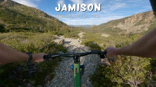
Absolutely beautiful and tough loop in The Lost Sierra. The road climb up has some spectacular views. About 8 miles of climbing and 4 miles of descending. The descent is quite technical, lots of rocks. If you're riding on a weekend there will be more and more hikers as you near the bottom.

Upper Jamison Creek Campground has parking spots for day use. Really nice bathrooms and water as well.

Detailed Description
Jamison Creek Loop is a 13 mile popular expert route located near Graeagle California. This mountain bike only route can be used one direction. This route includes 6 trails. This route climbs 2,460 ft with a max elevation of 7,264 ft then descends -2,460 ft.

Trail Issues on Route

  • Significant Issue / Amber: 3 trails (newest: Jan 9, 2026)
Local Trail Association
Local trail association
Sierra Buttes Trail Stewardship (www.sierratrails.org)
Please consider joining or donating to the local riding association to support trail development & maintenance.
Donate to earn trail karma!

Stats

  • Distance
    13 miles
  • Altitude min
    5,234 ft
  • Altitude start
    5,242 ft
  • Altitude end
    5,243 ft
  • Climb
    2,460 ft
  • Descent
    -2,460 ft
  • Grade max
    -76.1%
  • Grade min
    42.9%
  • Distance climb
    6 miles
  • Distance down
    5 miles
  • Distance flat
    1 mile

5 Reviews & Comments


We hope you've been enjoying Trailforks!

Create a FREE account to view route comments and much more.

Details

  • Riding area
  • Primary Activity
    Mountain Bike
  • Difficulty rating
    Black Diamond
  • Route Type
    Loop
  • Direction
    One Direction
no votes yet
close
3D
Trail Conditions
  • Unknown
  • Snow Groomed
  • Snow Packed
  • Snow Covered
  • Snow Cover Partial
  • Freeze/thaw Cycle
  • Icy
  • Prevalent Mud
  • Wet
  • Variable
  • Ideal
  • Dry
  • Very Dry
Trail Flow (Ridden Direction)
Trailforks scans users ridelogs to determine the most popular direction each trail is ridden. A good flowing trail network will have most trails flowing in a single direction according to their intension.
The colour categories are based on what percentage of riders are riding a trail in its intended direction.
  • > 96%
  • > 90%
  • > 80%
  • > 70%
  • > 50%
  • < 50%
  • bi-directional trail
  • no data
Trail Last Ridden
Trailforks scans ridelogs to determine the last time a trail was ridden.
  • < 2 days
  • < 1 week
  • < 2 weeks
  • < 1 month
  • < 6 months
  • > 6 months
Trail Ridden Direction
The intended direction a trail should be ridden.
  • Downhill Only
  • Downhill Primary
  • Both Directions
  • Uphill Primary
  • Uphill Only
  • One Direction
Contribute Details
Colors indicate trail is missing specified detail.
  • Description
  • Photos
  • Description & Photos
  • Videos
Trail Popularity ?
Trailforks scans ridelogs to determine which trails are ridden the most in the last 9 months. Trails are compared with nearby trails in the same city region with a possible 25 colour shades. Think of this as a heatmap, more rides = more kinetic energy = warmer colors.
  • most popular
  • popular
  • less popular
  • not popular
ATV/ORV/OHV Filter
Max Vehicle Width
inches
US Cell Coverage
Legend
cell carrier legend

Radar Time
Activity Recordings
Trailforks uses anonymized public activity data. ?
Activity Recordings
Trailforks uses anonymized public activity data. ?
Personal Heatmap
Activity Types
all / none
Options
2
Date range month
Winter Trails
Warning A routing network for winter maps does not exist. Selecting trails using the winter trails layer has been disabled.
Missing Trails
Most Popular
Least Popular
Trails are colored based on popularity. The more popular a trail is, the more red. Less popular trails trend towards green.
Jump Magnitude Heatmap
Heatmap of where riders jump on trails. Zoom in to see individual jumps, click circles to view jump details.
BC Backroad Status

Service Road Atlas is a free to use, community-driven service for viewing and creating reports on the numerous back-country service roads around B.C. and Alberta.

map legend
Slope Aspect
Direction the slope faces
Flat N NE E SE S SW W NW
Trails Deemphasized
Trails are shown in grey.
disable
Only show trails with no bike usage.
Enable
Suggested Layers
Based on selected activity type

    Save the current map location and zoom level as your default home location whenever this page is loaded.

    Save
    Trail transparency
    • Singletrack
    • Unpaved
    • Paved
    237
    556
    527
    youtuber Jamison / Graeagle, CA / MTB
    Jamison / Graeagle, CA / MTB
    7:30 | 67 | comments: 0 | favs:
    Nov 5, 2025
    youtuber Jamison / Graeagle, CA / MTB
    Jamison / Graeagle, CA / MTB
    7:30 | 47 | comments: 0 | favs:
    Nov 5, 2025

    Recent Trail Reports Along Route

    statustraildateconditiondescription
    Jamison Creek Trail (Grass Lake)
    May 31, 2026 @ 8:13am (America/Los_Angeles)
    May 31, 2026
    one tree down
    Sloat McRae Road
    Jan 9, 2026 @ 11:18am (America/Los_Angeles)
    Jan 9, 2026
    Jamison Creek Trail (Rock Garden)
    Jan 9, 2026 @ 11:18am (America/Los_Angeles)
    Jan 9, 2026
    Jamison Creek Trail (Top)
    Jan 9, 2026 @ 11:18am (America/Los_Angeles)
    Jan 9, 2026
    Jamison Creek Trail (Smith to Mine)
    Jul 12, 2025 @ 9:48am
    Jul 12, 2025
    more reports »
    • By bkxcTF Pro Everstoke & contributors
    • #41725 - 1,616 views

    Hit the Trail

    Open in App

    Get this route on your phone instantly.

    Download Route

    Save to wishlist, Garmin & download.