
Open in App
Get this route on your phone instantly.
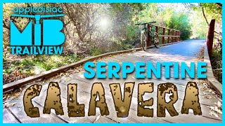
This route should access all the fun and legal trails at Lake Calavera. Be careful as the serpentine route borders the Calaveras Natural Preserve, and ends at a fork to the trailhead connecting the open space preserve and Calaveras Natural Preserve
We hope you've been enjoying Trailforks!
Create a FREE account to view route comments and much more.
| 1,640 ft | |||||
| 1,526 ft | |||||
| 92 ft | |||||
| 673 ft | |||||
| 535 ft | |||||
| 1,070 ft | |||||
| 2,484 ft | |||||
| 4,587 ft | |||||
| 2,411 ft | |||||
| 1,467 ft | |||||
| 2,464 ft | |||||
| 410 ft | |||||
| 2,461 ft | |||||
| 2,940 ft | |||||
| 886 ft |

Service Road Atlas is a free to use, community-driven service for viewing and creating reports on the numerous back-country service roads around B.C. and Alberta.
Save the current map location and zoom level as your default home location whenever this page is loaded.
Save