
Open in App
Get this route on your phone instantly.
he ride starts from the North Table Mountain Park main parking lot with a grueling climb. At the top of the hill, you'll see a climbing area to your right and a trail merge ahead. Top out at the trail merge and continue straight onto the Tilting Mesa Trail (North Table Loop continues on to the right).
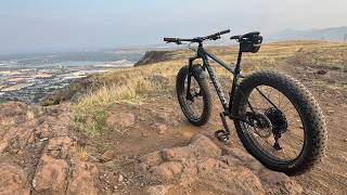
Enjoy some cross country riding along the top of North Table mountain. You'll merge onto Mesa Top briefly and continue on towards Rim Rock trail. You'll see the entrance to Rim Rock trail flanked by two large rocks and signs. Rim Rock is a fun, flowy climb through tall grass with views looking north towards Boulder. There is an awesome viewpoint as you crest the highpoint of the trail that overlooks Denver. From here, enjoy a fun, flowy descent with a couple technical moments.
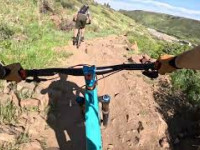
You'll finish by crossing a small bridge and ending at a stone staircase. Walk or climb your bike up the staircase and continue on this trail (Mesa Top). At your next junction, make a left onto Cottonwood Canyon Trail. This a fun descent which will connect you with North Table Loop. There is one technical rock garden where beginner and some intermediate riders will be more confident walking their bike.
Once you connect with North Table Loop, you'll continue all the way around the perimeter of North Table Mountain and return back to the parking lot.
We hope you've been enjoying Trailforks!
Create a FREE account to view route comments and much more.
| 1,411 ft | |||||
| 1 mile | |||||
| 404 ft | |||||
| 2 miles | |||||
| 1,243 ft | |||||
| 5,262 ft | |||||
| 1 mile | |||||
| 4,117 ft | |||||
| 5,036 ft |

Service Road Atlas is a free to use, community-driven service for viewing and creating reports on the numerous back-country service roads around B.C. and Alberta.
Save the current map location and zoom level as your default home location whenever this page is loaded.
Save