5.1 miles
Distance
1,176 ft
Climb
-1,166 ft
Descent
3,746 ft
High Point
9 ft
Altitude change
2,657 ft
Altitude min
2,657 ft
Altitude start
2,667 ft
Altitude end
-88%
Grade max
51.1%
Grade min
2 miles
Distance climb
3 miles
Distance down
646 ft
Distance flat

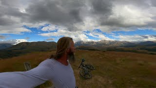
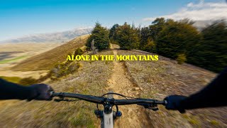
Great loop ride from Mistletoe Flat campground with plenty of variety and some views from near Lyndon Saddle.

Detailed Description
Luge Loop is a 5 mile popular intermediate route located near Castle Hill. This mountain bike only route can be used one direction and has a moderate overall physical rating. This route includes 4 trails. This route climbs 1,176 ft with a max elevation of 3,746 ft then descends -1,166 ft.

Trail Issues on Route

  • Significant Issue / Amber: 1 trail (newest: Jan 13, 2026)
Local Trail Association
Local trail association
Craigieburn Trails (www.craigieburntrails.org.nz)
Please consider joining or donating to the local riding association to support trail development & maintenance.
Donate to earn trail karma!

Stats

  • Distance
    5 miles
  • Avg time
    1 hr 8 min
  • Altitude min
    2,657 ft
  • Altitude start
    2,657 ft
  • Altitude end
    2,667 ft
  • Climb
    1,176 ft
  • Descent
    -1,166 ft
  • Grade max
    -88%
  • Grade min
    51.1%
  • Distance climb
    2 miles
  • Distance down
    3 miles
  • Distance flat
    646 ft

7 Reviews & Comments


We hope you've been enjoying Trailforks!

Create a FREE account to view route comments and much more.

Trails in Route

Sidle 734,072 ft
Lyndon Saddle1 mile
Luge1 mile

Details

  • Riding area
  • Primary Activity
    Mountain Bike
  • Difficulty rating
    Blue
  • Route Type
    Loop
  • Bike type
    AM
  • Direction
    One Direction
  • Physical rating
    Moderate
  • Ridelogs
    38
Avg: 4.65 (3 votes)
close
3D
Trail Conditions
  • Unknown
  • Snow Groomed
  • Snow Packed
  • Snow Covered
  • Snow Cover Partial
  • Freeze/thaw Cycle
  • Icy
  • Prevalent Mud
  • Wet
  • Variable
  • Ideal
  • Dry
  • Very Dry
Trail Flow (Ridden Direction)
Trailforks scans users ridelogs to determine the most popular direction each trail is ridden. A good flowing trail network will have most trails flowing in a single direction according to their intension.
The colour categories are based on what percentage of riders are riding a trail in its intended direction.
  • > 96%
  • > 90%
  • > 80%
  • > 70%
  • > 50%
  • < 50%
  • bi-directional trail
  • no data
Trail Last Ridden
Trailforks scans ridelogs to determine the last time a trail was ridden.
  • < 2 days
  • < 1 week
  • < 2 weeks
  • < 1 month
  • < 6 months
  • > 6 months
Trail Ridden Direction
The intended direction a trail should be ridden.
  • Downhill Only
  • Downhill Primary
  • Both Directions
  • Uphill Primary
  • Uphill Only
  • One Direction
Contribute Details
Colors indicate trail is missing specified detail.
  • Description
  • Photos
  • Description & Photos
  • Videos
Trail Popularity ?
Trailforks scans ridelogs to determine which trails are ridden the most in the last 9 months. Trails are compared with nearby trails in the same city region with a possible 25 colour shades. Think of this as a heatmap, more rides = more kinetic energy = warmer colors.
  • most popular
  • popular
  • less popular
  • not popular
ATV/ORV/OHV Filter
Max Vehicle Width
inches
US Cell Coverage
Legend
cell carrier legend

Radar Time
Activity Recordings
Trailforks uses anonymized public activity data. ?
Activity Recordings
Trailforks uses anonymized public activity data. ?
Personal Heatmap
Activity Types
all / none
Options
2
Date range month
Winter Trails
Warning A routing network for winter maps does not exist. Selecting trails using the winter trails layer has been disabled.
Missing Trails
Most Popular
Least Popular
Trails are colored based on popularity. The more popular a trail is, the more red. Less popular trails trend towards green.
Jump Magnitude Heatmap
Heatmap of where riders jump on trails. Zoom in to see individual jumps, click circles to view jump details.
BC Backroad Status

Service Road Atlas is a free to use, community-driven service for viewing and creating reports on the numerous back-country service roads around B.C. and Alberta.

map legend
Slope Aspect
Direction the slope faces
Flat N NE E SE S SW W NW
Trails Deemphasized
Trails are shown in grey.
disable
Only show trails with no bike usage.
Enable
Suggested Layers
Based on selected activity type

    Save the current map location and zoom level as your default home location whenever this page is loaded.

    Save
    Trail transparency
    • Singletrack
    • Unpaved
    25
    25
    35
    471
    youtuber Craigieburn is the worst riding ever!
    Craigieburn is the worst riding ever!
    5:03 | 258 | comments: 0 | favs:
    Feb 8, 2023
    youtuber My Solo Ride in New Zealand's MTB Paradise!
    My Solo Ride in New Zealand's MTB Paradise!
    trail: Luge
    18:29 | 311 | comments: 0 | favs:
    Dec 18, 2022

    Recent Trail Reports Along Route

    statustraildateconditiondescription
    Luge
    Mar 1, 2026 @ 10:21am (Pacific/Auckland)
    Feb 28, 2026
    Great downhill fun with lots of roots.
    Lyndon Saddle
    Feb 22, 2026 @ 8:30am (Pacific/Auckland)
    Feb 21, 2026
    more reports »
    • By conorboydTF Pro CT & contributors
    • #6742 - 2,324 views

    Hit the Trail

    Open in App

    Get this route on your phone instantly.

    Download Route

    Save to wishlist, Garmin & download.