
Open in App
Get this route on your phone instantly.
Helena Classic
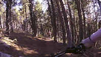
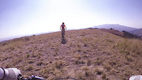
Four miles of the Continental Divide Trail lead to a locals' favorite downhill on the Switchback Ridge Trail. The CDT portion doesn't climb very much, but it is strewn with very challenging rock gardens. The downhill is relatively buff until the last few hundred yards.
Exit Highway 12 at the Cromwell-Dixon Campground, and drive up the hill to the Continental Divide overlook. The trail starts at the stairs. There is a gate shortly after entering the forest; be sure to close it behind you. As the CDT rises into an open meadow, stay left towards the trees to start the downhill.
During the summer months, Bike Helena and Vigilante Shuttles & Tours runs shuttles from bottom of Switchback Ridge up to the CDT overlook. This is a great way to do this ride, as it eliminates a shuttle run or a long road climb. The schedule is available at the Bike Helena website: http://www.bikehelena.com/index.php/trail-rider/
We hope you've been enjoying Trailforks!
Create a FREE account to view route comments and much more.

Service Road Atlas is a free to use, community-driven service for viewing and creating reports on the numerous back-country service roads around B.C. and Alberta.
Save the current map location and zoom level as your default home location whenever this page is loaded.
Save