11.9 miles
Distance
902 ft
Climb
-901 ft
Descent
1,394 ft
High Point
0 ft
Altitude change
1,209 ft
Altitude min
1,227 ft
Altitude start
1,227 ft
Altitude end
-0%
Grade
-19.9%
Grade max
25.5%
Grade min
5 miles
Distance climb
5 miles
Distance down
3 miles
Distance flat

WARNING ⚠: Please read the IMBA Responsible Riding Rules of the Trail prior to riding.
WARNING ⚠: Please read the safety warnings on the Minnesota Department of Natural Resources Cuyuna Country State Recreation Area Trail Map.

This mountain biking loop takes you throughout the entire Mahnomen Unit of singletrack trails for a complete “Big Side” (as locals call it) experience. The loop starts and finishes in the Cuyuna Country State Recreation Area (CCSRA) Miner’s Mountain Rally Center. A Minnesota State Park Permit is required to park a car or truck in this area.

The entrance to the Cuyuna Country State Recreation Area will be to your left after you drive past the last stop sign within the City of Ironton via HWY 30/Irene Avenue. The entrance to the Cuyuna Country State Recreation Area is super close to town, but it’s kind of easy to miss the entrance as well.

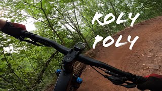
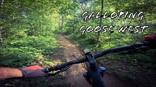
This 10+ mile loop will take you through the Mahnomen Unit where you’ll experience both flowy singletrack and gravity Flow Country singletrack including Sand Hog and Screamer. Depending on your mountain biking speed, this could be a couple of hours, or a full day experience.

The trails within this loop are all one-way, one-direction singletrack trail.

source: Cuyuna.com
Detailed Description
Mahnomen: Full Loop is a 12 mile popular expert route located near Crosby-Ironton Minnesota. This mountain bike primary route can be used one direction and has a moderate overall physical rating. This route includes 12 trails. This route climbs 902 ft with a max elevation of 1,394 ft then descends -901 ft.

Trail Issues on Route

  • Minor Issue / Yellow: 5 trails (newest: Jun 3, 2026)
Local Trail Association
Local trail association
Cuyuna Lakes Mountain Bike Crew (cuyunalakesmtb.com)
Please consider joining or donating to the local riding association to support trail development & maintenance.
Donate to earn trail karma!

Stats

  • Distance
    12 miles
  • Avg time
    1 hr 42 min
  • Altitude min
    1,209 ft
  • Altitude start
    1,227 ft
  • Altitude end
    1,227 ft
  • Climb
    902 ft
  • Descent
    -901 ft
  • Grade
    -0%
  • Grade max
    -19.9%
  • Grade min
    25.5%
  • Distance climb
    5 miles
  • Distance down
    5 miles
  • Distance flat
    3 miles

17 Reviews & Comments


We hope you've been enjoying Trailforks!

Create a FREE account to view route comments and much more.

Details

  • Primary Activity
    Mountain Bike
  • Other Activities
    • E-Bike
    • Hike
    • Trail Running
    • Snowshoe
  • Difficulty rating
    Black Diamond
  • Route Type
    Loop
  • eBike Allowed
  • Bike type
    AM, XC, Fat
  • Direction
    One Direction
  • Physical rating
    Moderate
  • Ridelogs
    40
no votes yet
close
3D
Trail Conditions
  • Unknown
  • Snow Groomed
  • Snow Packed
  • Snow Covered
  • Snow Cover Partial
  • Freeze/thaw Cycle
  • Icy
  • Prevalent Mud
  • Wet
  • Variable
  • Ideal
  • Dry
  • Very Dry
Trail Flow (Ridden Direction)
Trailforks scans users ridelogs to determine the most popular direction each trail is ridden. A good flowing trail network will have most trails flowing in a single direction according to their intension.
The colour categories are based on what percentage of riders are riding a trail in its intended direction.
  • > 96%
  • > 90%
  • > 80%
  • > 70%
  • > 50%
  • < 50%
  • bi-directional trail
  • no data
Trail Last Ridden
Trailforks scans ridelogs to determine the last time a trail was ridden.
  • < 2 days
  • < 1 week
  • < 2 weeks
  • < 1 month
  • < 6 months
  • > 6 months
Trail Ridden Direction
The intended direction a trail should be ridden.
  • Downhill Only
  • Downhill Primary
  • Both Directions
  • Uphill Primary
  • Uphill Only
  • One Direction
Contribute Details
Colors indicate trail is missing specified detail.
  • Description
  • Photos
  • Description & Photos
  • Videos
Trail Popularity ?
Trailforks scans ridelogs to determine which trails are ridden the most in the last 9 months. Trails are compared with nearby trails in the same city region with a possible 25 colour shades. Think of this as a heatmap, more rides = more kinetic energy = warmer colors.
  • most popular
  • popular
  • less popular
  • not popular
ATV/ORV/OHV Filter
Max Vehicle Width
inches
US Cell Coverage
Legend
cell carrier legend

Radar Time
Activity Recordings
Trailforks uses anonymized public activity data. ?
Activity Recordings
Trailforks uses anonymized public activity data. ?
Personal Heatmap
Activity Types
all / none
Options
2
Date range month
Winter Trails
Warning A routing network for winter maps does not exist. Selecting trails using the winter trails layer has been disabled.
Missing Trails
Most Popular
Least Popular
Trails are colored based on popularity. The more popular a trail is, the more red. Less popular trails trend towards green.
Jump Magnitude Heatmap
Heatmap of where riders jump on trails. Zoom in to see individual jumps, click circles to view jump details.
BC Backroad Status

Service Road Atlas is a free to use, community-driven service for viewing and creating reports on the numerous back-country service roads around B.C. and Alberta.

map legend
Slope Aspect
Direction the slope faces
Flat N NE E SE S SW W NW
Trails Deemphasized
Trails are shown in grey.
disable
Only show trails with no bike usage.
Enable
Suggested Layers
Based on selected activity type

    Save the current map location and zoom level as your default home location whenever this page is loaded.

    Save
    Trail transparency
    • Singletrack
    • Unpaved
    45
    47
    26
    26
    Roly Poly Trail at Cuyuna, MN
    Roly Poly Trail at Cuyuna, MN
    trail: Roly Poly
    5:33 | 122 | comments: 0 | favs:
    Oct 12, 2024
    Galloping Goose West Trail at Cuyuna, MN
    Galloping Goose West Trail at Cuyuna, MN
    6:44 | 107 | comments: 0 | favs:
    Oct 12, 2024

    Recent Trail Reports Along Route

    statustraildateconditiondescription
    Sand Hog Mountain
    Jun 3, 2026 @ 6:39pm (America/Chicago)
    3 days
    reporter
    Roly Poly
    May 23, 2026 @ 4:15pm (America/Chicago)
    May 23, 2026
    reporter
    Miner's Mountain
    May 23, 2026 @ 4:15pm (America/Chicago)
    May 23, 2026
    reporter
    Crusher
    May 23, 2026 @ 4:15pm (America/Chicago)
    May 23, 2026
    reporter
    Chute
    May 23, 2026 @ 4:15pm (America/Chicago)
    May 23, 2026
    reporter
    more reports »
    • By CycleKriegTF Pro & contributors
    • #18973 - 1,926 views

    Hit the Trail

    Open in App

    Get this route on your phone instantly.

    Download Route

    Save to wishlist, Garmin & download.