
Open in App
Get this route on your phone instantly.
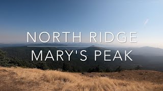
Trails on Marys Peak are closed to bikes Oct 15th thru May 15th, and E-bikes are not allowed on these trails at any time.
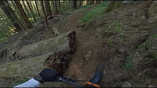
Park at end of Woods Creek Road. Go around the gate and start climbing (50ft in, off to your right you will see the exit for North Ridge Trail). Climb the gravel road for about 2.5 miles. A small descent brings you to another gate. Go around and take East Ridge Trail on your Right. Climb trail for 2 miles (Halfway up there is an option to cut across to North Ridge on "Tie Trail", but you will miss the view up top & a nice section of North Ridge Trail). Reaching the top parking lot, enjoy the view. A gravel road goes up to the very top of Marys if you're game, but stay on the gravel road, side trails are closed to bikes. The trailhead for North Ridge Trail is on the same side of the parking lot as you arrived. Just ride the sidewalk towards the paved entrance/exit for the main parking lot. I think the trailhead is unmarked. The trail is fast, watch for hikers & downed trees. About 1 mile down the trail, Tie Trail comes in from the right, stay left to continue down North Ridge Trail. The trail eventually pops out on the gravel road near the gate where you started.
We hope you've been enjoying Trailforks!
Create a FREE account to view route comments and much more.
| 5,207 ft | |||||
| 4 miles |

Service Road Atlas is a free to use, community-driven service for viewing and creating reports on the numerous back-country service roads around B.C. and Alberta.
Save the current map location and zoom level as your default home location whenever this page is loaded.
Save