2.3 miles
Distance
-951 ft
Descent
1 mile
High Point
-953 ft
Altitude change
4,735 ft
Altitude min
5,687 ft
Altitude start
4,734 ft
Altitude end
-7.9%
Grade
-49.3%
Grade max
3.9%
Grade min
33 ft
Distance climb
2 miles
Distance down
148 ft
Distance flat

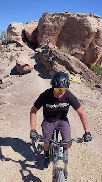
Max Gnar is a triple trial conglomerate of Free Lunch, Pucker-Up, and Moto, though there is a very brief segment of the Tabeguache Trail called "Widowmaker Hill" Max Gnar is the 3rd stage of the local race called The Grand Enduro.

Max Gnar starts with Free Lunch. A violent bike breaking terrain with lots of sketch drops is on the menu for this ride. Free Lunch has cost me more money in component repair than any other trail I've ever ridden. Hence the name, Free Lunch, because there is no such thing. Bring some spare parts and be prepared to fix a flat, because this trail wants only you finest riding and most durable parts. Expect 3 to 4 6ft. drops and chunky flat sections.

Pucker Up brings in my favorite section of Max Gnar as this is mostly downhill and doesn't require any pedaling until the end. Drops, step ups, and isolated tight techy bits are what you can expect. When you master the lines, this is a trail that will never get old. Speaking of lines, there is a final sketchy line at the end called the Cathedral Drop.

Moto, wraps up Max Gnar. Unlike the previous two trails of straight chunk and jank, Moto is going to give you a chance at fast and flowy conclusion with just a few drops that can be bypassed. The most important bit of information I can give you is to not ride this when wet. It won't last long Moto also takes longer than other trails in the area to dry out. Finish the ride at the foot of Bentonite Hill and the junction of Tabeguache.

Detailed Description
Max Gnar is a 2 mile extreme race route located near Grand Junction Colorado. This mountain bike only route can be used one direction and has a moderate overall physical rating. This route includes 5 trails. This route with a max elevation of 5,687 ft then descends -951 ft.
Route Supporters
Local Trail Association
Local trail association
COPMOBA - Grand Valley Trails Chapter (www.copmoba.org)
Please consider joining or donating to the local riding association to support trail development & maintenance.
Donate to earn trail karma!

Stats

  • Distance
    2 miles
  • Avg time
    1 hr 17 min
  • Altitude change
    -953 ft
  • Altitude min
    4,735 ft
  • Altitude start
    5,687 ft
  • Altitude end
    4,734 ft
  • Descent
    -951 ft
  • Grade
    -7.9%
  • Grade max
    -49.3%
  • Grade min
    3.9%
  • Distance climb
    33 ft
  • Distance down
    2 miles
  • Distance flat
    148 ft

17 Reviews & Comments


We hope you've been enjoying Trailforks!

Create a FREE account to view route comments and much more.

Trails in Route

Free Lunch1 mile
Tabeguache607 ft
Pucker Up1,499 ft
High Noon203 ft
Moto804 ft

Details

  • Race Course
  • Riding area
  • Primary Activity
    Mountain Bike
  • Difficulty rating
    Double Black Diamond
  • Route Type
    Point to Point
  • eBike Allowed
  • Bike type
    AM
  • Direction
    One Direction
  • Physical rating
    Moderate
  • Ridelogs
    5
no votes yet
close
3D
Trail Conditions
  • Unknown
  • Snow Groomed
  • Snow Packed
  • Snow Covered
  • Snow Cover Partial
  • Freeze/thaw Cycle
  • Icy
  • Prevalent Mud
  • Wet
  • Variable
  • Ideal
  • Dry
  • Very Dry
Trail Flow (Ridden Direction)
Trailforks scans users ridelogs to determine the most popular direction each trail is ridden. A good flowing trail network will have most trails flowing in a single direction according to their intension.
The colour categories are based on what percentage of riders are riding a trail in its intended direction.
  • > 96%
  • > 90%
  • > 80%
  • > 70%
  • > 50%
  • < 50%
  • bi-directional trail
  • no data
Trail Last Ridden
Trailforks scans ridelogs to determine the last time a trail was ridden.
  • < 2 days
  • < 1 week
  • < 2 weeks
  • < 1 month
  • < 6 months
  • > 6 months
Trail Ridden Direction
The intended direction a trail should be ridden.
  • Downhill Only
  • Downhill Primary
  • Both Directions
  • Uphill Primary
  • Uphill Only
  • One Direction
Contribute Details
Colors indicate trail is missing specified detail.
  • Description
  • Photos
  • Description & Photos
  • Videos
Trail Popularity ?
Trailforks scans ridelogs to determine which trails are ridden the most in the last 9 months. Trails are compared with nearby trails in the same city region with a possible 25 colour shades. Think of this as a heatmap, more rides = more kinetic energy = warmer colors.
  • most popular
  • popular
  • less popular
  • not popular
ATV/ORV/OHV Filter
Max Vehicle Width
inches
US Cell Coverage
Legend
cell carrier legend

Radar Time
Activity Recordings
Trailforks uses anonymized public activity data. ?
Activity Recordings
Trailforks uses anonymized public activity data. ?
Personal Heatmap
Activity Types
all / none
Options
2
Date range month
Winter Trails
Warning A routing network for winter maps does not exist. Selecting trails using the winter trails layer has been disabled.
Missing Trails
Most Popular
Least Popular
Trails are colored based on popularity. The more popular a trail is, the more red. Less popular trails trend towards green.
Jump Magnitude Heatmap
Heatmap of where riders jump on trails. Zoom in to see individual jumps, click circles to view jump details.
BC Backroad Status

Service Road Atlas is a free to use, community-driven service for viewing and creating reports on the numerous back-country service roads around B.C. and Alberta.

map legend
Slope Aspect
Direction the slope faces
Flat N NE E SE S SW W NW
Trails Deemphasized
Trails are shown in grey.
disable
Only show trails with no bike usage.
Enable
Suggested Layers
Based on selected activity type

    Save the current map location and zoom level as your default home location whenever this page is loaded.

    Save
    Trail transparency
    • Singletrack
    83
    71
    89
    1,525
    Moto Drop in Variant
    Moto Drop in Variant
    trail: Moto
    0:27 | 12 | comments: 0 | favs:
    Oct 9, 2025
    A fun alternate line dropping into one of the most fun DH trails in the Lunch Loop Trail System IG @darincarville
    Hugged a rock!
    Hugged a rock!
    trail: Free Lunch
    0:03 | 77 | comments: 0 | favs:
    Aug 1, 2024
    My friend recorded me crash on this 3 foot drop lol

    Recent Trail Reports Along Route

    statustraildateconditiondescription
    Tabeguache
    Jun 6, 2026 @ 6:27am (America/Denver)
    Jun 6, 2026
    Free Lunch
    May 21, 2026 @ 10:16am (America/Denver)
    May 21, 2026
    Moto
    May 21, 2026 @ 10:16am (America/Denver)
    May 21, 2026
    Pucker Up
    May 21, 2026 @ 10:16am (America/Denver)
    May 21, 2026
    High Noon
    Feb 26, 2026 @ 10:45am (America/Denver)
    Feb 26, 2026
    more reports »
    • By rclefevre & contributors
    • #11995 - 1,541 views

    Hit the Trail

    Open in App

    Get this route on your phone instantly.

    Download Route

    Save to wishlist, Garmin & download.