5.0 miles
Distance
202 ft
Climb
-2,528 ft
Descent
4,033 ft
High Point
-2,325 ft
Altitude change
1,653 ft
Altitude min
3,979 ft
Altitude start
1,654 ft
Altitude end
-8.7%
Grade
-77.7%
Grade max
15.2%
Grade min
4,872 ft
Distance climb
4 miles
Distance down
1,831 ft
Distance flat

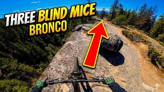
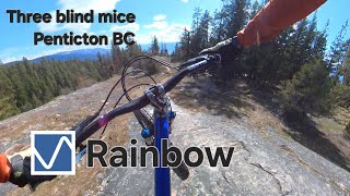
So, you find yourself at the top of 3 Blind Mice, you may ask yourself the following questions.
What's the fastest way to the bottom?
How can I ride some of the gnarliest terrain in the Mice?
How do I go full enduro?
Well, the answer to all those questions is MegaMiceAlanche. A top to bottom selection of the most technical, exciting, and fun trails you can find in the Penticton area. Rainbow, Bronco, Mosquito, Deadhorse Extensions, and then finish off through Flow Coaster and the iconic Tsweet Tsue.

Detailed Description
MegaMiceAlanche is a 5 mile popular expert route located near Penticton British Columbia. This mountain bike only route can be used one direction and has a moderate overall physical rating. This route includes 11 trails. This route climbs 202 ft with a max elevation of 4,033 ft then descends -2,528 ft.

Trail Issues on Route

  • Closed: 2 trails (newest: Jun 1, 2026)
  • Minor Issue / Yellow: 1 trail (newest: Jun 12, 2026)
Local Trail Association
Local trail association
Penticton and Area Cycling Association (www.bikepenticton.com)
Please consider joining or donating to the local riding association to support trail development & maintenance.
Donate to earn trail karma!

Trail Products

Stats

  • Distance
    5 miles
  • Avg time
    59 min 54 sec
  • Altitude change
    -2,325 ft
  • Altitude min
    1,653 ft
  • Altitude start
    3,979 ft
  • Altitude end
    1,654 ft
  • Climb
    202 ft
  • Descent
    -2,528 ft
  • Grade
    -8.7%
  • Grade max
    -77.7%
  • Grade min
    15.2%
  • Distance climb
    4,872 ft
  • Distance down
    4 miles
  • Distance flat
    1,831 ft

19 Reviews & Comments


We hope you've been enjoying Trailforks!

Create a FREE account to view route comments and much more.

Details

  • Riding area
  • Primary Activity
    Mountain Bike
  • Difficulty rating
    Black Diamond
  • Route Type
    Shuttled
  • eBike Allowed
  • Bike type
    AM
  • Direction
    One Direction
  • Physical rating
    Moderate
  • Ridelogs
    40
Avg: 4 (3 votes)
close
3D
Trail Conditions
  • Unknown
  • Snow Groomed
  • Snow Packed
  • Snow Covered
  • Snow Cover Partial
  • Freeze/thaw Cycle
  • Icy
  • Prevalent Mud
  • Wet
  • Variable
  • Ideal
  • Dry
  • Very Dry
Trail Flow (Ridden Direction)
Trailforks scans users ridelogs to determine the most popular direction each trail is ridden. A good flowing trail network will have most trails flowing in a single direction according to their intension.
The colour categories are based on what percentage of riders are riding a trail in its intended direction.
  • > 96%
  • > 90%
  • > 80%
  • > 70%
  • > 50%
  • < 50%
  • bi-directional trail
  • no data
Trail Last Ridden
Trailforks scans ridelogs to determine the last time a trail was ridden.
  • < 2 days
  • < 1 week
  • < 2 weeks
  • < 1 month
  • < 6 months
  • > 6 months
Trail Ridden Direction
The intended direction a trail should be ridden.
  • Downhill Only
  • Downhill Primary
  • Both Directions
  • Uphill Primary
  • Uphill Only
  • One Direction
Contribute Details
Colors indicate trail is missing specified detail.
  • Description
  • Photos
  • Description & Photos
  • Videos
Trail Popularity ?
Trailforks scans ridelogs to determine which trails are ridden the most in the last 9 months. Trails are compared with nearby trails in the same city region with a possible 25 colour shades. Think of this as a heatmap, more rides = more kinetic energy = warmer colors.
  • most popular
  • popular
  • less popular
  • not popular
ATV/ORV/OHV Filter
Max Vehicle Width
inches
US Cell Coverage
Legend
cell carrier legend

Radar Time
Activity Recordings
Trailforks uses anonymized public activity data. ?
Activity Recordings
Trailforks uses anonymized public activity data. ?
Personal Heatmap
Activity Types
all / none
Options
2
Date range month
Winter Trails
Warning A routing network for winter maps does not exist. Selecting trails using the winter trails layer has been disabled.
Missing Trails
Most Popular
Least Popular
Trails are colored based on popularity. The more popular a trail is, the more red. Less popular trails trend towards green.
Jump Magnitude Heatmap
Heatmap of where riders jump on trails. Zoom in to see individual jumps, click circles to view jump details.
BC Backroad Status

Service Road Atlas is a free to use, community-driven service for viewing and creating reports on the numerous back-country service roads around B.C. and Alberta.

map legend
Slope Aspect
Direction the slope faces
Flat N NE E SE S SW W NW
Trails Deemphasized
Trails are shown in grey.
disable
Only show trails with no bike usage.
Enable
Suggested Layers
Based on selected activity type

    Save the current map location and zoom level as your default home location whenever this page is loaded.

    Save
    Trail transparency
    • Singletrack
    633
    424
    828
    1,077 | 1 faves
    My favourite trail in the Mice
    My favourite trail in the Mice
    trail: Bronco
    8:05 | 187 | comments: 0 | favs:
    Apr 20, 2024
    Rainbow - Three blind mice, Penticton BC
    Rainbow - Three blind mice, Penticton BC
    trail: Rainbow
    5:14 | 126 | comments: 0 | favs:
    Apr 26, 2025

    Recent Trail Reports Along Route

    statustraildateconditiondescription
    Black Bear
    Jun 12, 2026 @ 2:31pm (America/Vancouver)
    Jun 12, 2026
    Big tree still not cleared
    Rainbow
    Jun 11, 2026 @ 6:11pm (America/Vancouver)
    Jun 11, 2026
    Tree down near top
    Flow Coaster - Jumps
    Jun 1, 2026 @ 12:46pm (America/Creston)
    Jun 1, 2026
    Mosquito
    Apr 26, 2026 @ 10:33am (America/Vancouver)
    Apr 26, 2026
    Dead Horse
    Apr 26, 2026 @ 10:33am (America/Vancouver)
    Apr 26, 2026
    more reports »
    • By letsgoridebikes18 & contributors
    • #9710 - 2,724 views

    Hit the Trail

    Open in App

    Get this route on your phone instantly.

    Download Route

    Save to wishlist, Garmin & download.