15.8 miles
Distance
3,120 ft
Climb
-2,458 ft
Descent
3,989 ft
High Point
657 ft
Altitude change
1,144 ft
Altitude min
1,157 ft
Altitude start
1,814 ft
Altitude end
0.8%
Grade
-36%
Grade max
59.1%
Grade min
8 miles
Distance climb
6 miles
Distance down
1 mile
Distance flat

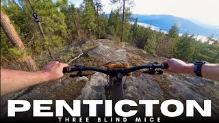
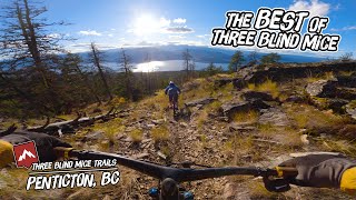
one big up, three Enduros

E1 - Fast!
E2 - Tech with an uphill finish!
E3 - Long a bit of everything, and lots of it!

Detailed Description
MegaVolt eEnduro is a 16 mile popular easy route located near Naramata British Columbia. This e-bike primary route. This route includes 9 trails. This route climbs 3,120 ft with a max elevation of 3,989 ft then descends -2,458 ft.

Trail Issues on Route

  • Minor Issue / Yellow: 2 trails (newest: Jun 11, 2026)
Local Trail Association
Please consider joining or donating to the local riding association to support trail development & maintenance.
Donate to earn trail karma!

Stats

  • Distance
    16 miles
  • Altitude change
    657 ft
  • Altitude min
    1,144 ft
  • Altitude start
    1,157 ft
  • Altitude end
    1,814 ft
  • Climb
    3,120 ft
  • Descent
    -2,458 ft
  • Grade
    0.8%
  • Grade max
    -36%
  • Grade min
    59.1%
  • Distance climb
    8 miles
  • Distance down
    6 miles
  • Distance flat
    1 mile

14 Reviews & Comments


We hope you've been enjoying Trailforks!

Create a FREE account to view route comments and much more.

Route Sections

1 Enduro #2 Eagle, a viciously techy downhill, and then a uphill section to the finish..why not, its an eEnduro!
  • 1 mile distance
  • 126 ft climb
  • -307 ft descent
2 Enduro #3: Long and Intense...great views!
  • 2 miles distance
  • 5 ft climb
  • -1,209 ft descent
3 Enduro #1: Sidewinder...crazy fast, crazy fun!
  • 2 miles distance
  • 0 ft climb
  • -706 ft descent

Trails in Route

Far Out2 miles
Neverland - Lower2 miles
Neverland - Upper2 miles
Sidewinder2,638 ft
Sidewinder1 mile
Eagle3,399 ft
Raven2,431 ft
Three Witches2,507 ft
Rattlesnake4,308 ft

Details

  • Riding area
  • Primary Activity
    E-Bike
  • Other Activities
    • Mountain Bike
  • Difficulty rating
    Green
  • eBike Allowed
no votes yet
close
3D
Trail Conditions
  • Unknown
  • Snow Groomed
  • Snow Packed
  • Snow Covered
  • Snow Cover Partial
  • Freeze/thaw Cycle
  • Icy
  • Prevalent Mud
  • Wet
  • Variable
  • Ideal
  • Dry
  • Very Dry
Trail Flow (Ridden Direction)
Trailforks scans users ridelogs to determine the most popular direction each trail is ridden. A good flowing trail network will have most trails flowing in a single direction according to their intension.
The colour categories are based on what percentage of riders are riding a trail in its intended direction.
  • > 96%
  • > 90%
  • > 80%
  • > 70%
  • > 50%
  • < 50%
  • bi-directional trail
  • no data
Trail Last Ridden
Trailforks scans ridelogs to determine the last time a trail was ridden.
  • < 2 days
  • < 1 week
  • < 2 weeks
  • < 1 month
  • < 6 months
  • > 6 months
Trail Ridden Direction
The intended direction a trail should be ridden.
  • Downhill Only
  • Downhill Primary
  • Both Directions
  • Uphill Primary
  • Uphill Only
  • One Direction
Contribute Details
Colors indicate trail is missing specified detail.
  • Description
  • Photos
  • Description & Photos
  • Videos
Trail Popularity ?
Trailforks scans ridelogs to determine which trails are ridden the most in the last 9 months. Trails are compared with nearby trails in the same city region with a possible 25 colour shades. Think of this as a heatmap, more rides = more kinetic energy = warmer colors.
  • most popular
  • popular
  • less popular
  • not popular
ATV/ORV/OHV Filter
Max Vehicle Width
inches
US Cell Coverage
Legend
cell carrier legend

Radar Time
Activity Recordings
Trailforks uses anonymized public activity data. ?
Activity Recordings
Trailforks uses anonymized public activity data. ?
Personal Heatmap
Activity Types
all / none
Options
2
Date range month
Winter Trails
Warning A routing network for winter maps does not exist. Selecting trails using the winter trails layer has been disabled.
Missing Trails
Most Popular
Least Popular
Trails are colored based on popularity. The more popular a trail is, the more red. Less popular trails trend towards green.
Jump Magnitude Heatmap
Heatmap of where riders jump on trails. Zoom in to see individual jumps, click circles to view jump details.
BC Backroad Status

Service Road Atlas is a free to use, community-driven service for viewing and creating reports on the numerous back-country service roads around B.C. and Alberta.

map legend
Slope Aspect
Direction the slope faces
Flat N NE E SE S SW W NW
Trails Deemphasized
Trails are shown in grey.
disable
Only show trails with no bike usage.
Enable
Suggested Layers
Based on selected activity type

    Save the current map location and zoom level as your default home location whenever this page is loaded.

    Save
    Trail transparency
    • Singletrack
    49
    82
    701 | 3 comments
    418
    Golden hour in wine country
    Golden hour in wine country
    trail: Eagle
    5:05 | 97 | comments: 0 | favs:
    Apr 25, 2025

    Recent Trail Reports Along Route

    statustraildateconditiondescription
    Neverland - Upper
    Jun 17, 2026 @ 9:01am (America/Creston)
    17 hours
    Neverland - Lower
    Jun 17, 2026 @ 9:01am (America/Creston)
    17 hours
    Three Witches
    Jun 11, 2026 @ 6:59pm (America/Vancouver)
    Jun 11, 2026
    Tree down
    Rattlesnake
    May 15, 2026 @ 7:37pm (America/Vancouver)
    May 15, 2026
    Lower Rattlesnake is clear.
    Sidewinder
    Apr 24, 2026 @ 11:23am (America/Creston)
    Apr 24, 2026
    more reports »
    • By jstromgrenTF Pro BCBR & contributors
    • #55839 - 970 views

    Hit the Trail

    Open in App

    Get this route on your phone instantly.

    Download Route

    Save to wishlist, Garmin & download.