30.6 miles
Distance
3,356 ft
Climb
-4,643 ft
Descent
2 miles
High Point
-1,287 ft
Altitude change
6,834 ft
Altitude min
8,120 ft
Altitude start
6,834 ft
Altitude end
-0.8%
Grade
-76.6%
Grade max
74%
Grade min
12 miles
Distance climb
16 miles
Distance down
2 miles
Distance flat

The course is subject to change as required by landowners. If any changes are required, they will be announced to all race participants via email.

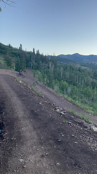
Course map for the Mid Mountain 50K. The first several miles of the course are on one of Deer Valley's downhill mountain bike trails. We have been given special permission to use that trail on race day. Please do not attempt to run on the trail during training as it is typically a bike-only trail.

Detailed Description
Mid Mountain 50k is a 31 mile moderately popular intermediate race route located near Park City Utah. This trail running only route. This route includes 12 trails. This route climbs 3,356 ft with a max elevation of 8,509 ft then descends -4,643 ft.

Trail Issues on Route

  • Minor Issue / Yellow: 1 trail (newest: May 8, 2026)
Bike Park

Stats

  • Distance
    31 miles
  • Altitude change
    -1,287 ft
  • Altitude min
    6,834 ft
  • Altitude start
    8,120 ft
  • Altitude end
    6,834 ft
  • Climb
    3,356 ft
  • Descent
    -4,643 ft
  • Grade
    -0.8%
  • Grade max
    -76.6%
  • Grade min
    74%
  • Distance climb
    12 miles
  • Distance down
    16 miles
  • Distance flat
    2 miles

34 Reviews & Comments


We hope you've been enjoying Trailforks!

Create a FREE account to view route comments and much more.

Route POI

Aid StationAid Station #2Aid Station
Aid StationAid Station #3Aid Station
Aid StationAid Station #4Aid Station
Aid StationAid Station #5Aid Station
Aid StationAid Station #6Aid Station
Aid StationAid Station #7Aid Station
Aid StationAid Station #8Aid Station
Aid StationAid Station #1Aid Station
RestroomsRed Pine BathroomsRestrooms

Details

  • Race Course
  • Race Date
    Saturday August 17, 2024 at 06:00am
  • Riding area
  • Primary Activity
    Trail Running
  • Difficulty rating
    Blue
  • eBike Allowed

Directions

  1. Walk east on Legacy Loop.
  2. Continue for 100 meters.
  3. Walk northeast on Legacy Loop.
  4. Continue for 300 meters.
  5. Walk north on UOP.
  6. Continue for 200 meters.
  7. Walk south on UOP.
  8. Continue for 200 meters.
  9. Walk south on UOP.
  10. Continue for 30 meters.
  11. Turn left onto Iron Bill.
  12. Continue for 100 meters.
  13. Walk north on Iron Bill.
  14. Continue for 400 meters.
  15. Walk southeast on Iron Bill.
  16. Continue for 200 meters.
  17. Walk south on Iron Bill.
  18. Continue for 300 meters.
  19. Walk north on Iron Bill.
  20. Continue for 200 meters.
  21. Walk northwest on Iron Bill.
  22. Continue for 20 meters.
  23. Walk east on Iron Bill.
  24. Continue for 60 meters.
  25. Walk southeast on Iron Bill.
  26. Continue for 50 meters.
  27. Walk east on Iron Bill.
  28. Continue for 40 meters.
  29. Walk northwest on Iron Bill.
  30. Continue for 60 meters.
  31. Walk east on Iron Bill.
  32. Continue for 200 meters.
  33. Walk north on Iron Bill.
  34. Continue for less than 10 meters.
Avg: 5 (1 votes)
close
3D
Trail Conditions
  • Unknown
  • Snow Groomed
  • Snow Packed
  • Snow Covered
  • Snow Cover Partial
  • Freeze/thaw Cycle
  • Icy
  • Prevalent Mud
  • Wet
  • Variable
  • Ideal
  • Dry
  • Very Dry
Trail Flow (Ridden Direction)
Trailforks scans users ridelogs to determine the most popular direction each trail is ridden. A good flowing trail network will have most trails flowing in a single direction according to their intension.
The colour categories are based on what percentage of riders are riding a trail in its intended direction.
  • > 96%
  • > 90%
  • > 80%
  • > 70%
  • > 50%
  • < 50%
  • bi-directional trail
  • no data
Trail Last Ridden
Trailforks scans ridelogs to determine the last time a trail was ridden.
  • < 2 days
  • < 1 week
  • < 2 weeks
  • < 1 month
  • < 6 months
  • > 6 months
Trail Ridden Direction
The intended direction a trail should be ridden.
  • Downhill Only
  • Downhill Primary
  • Both Directions
  • Uphill Primary
  • Uphill Only
  • One Direction
Contribute Details
Colors indicate trail is missing specified detail.
  • Description
  • Photos
  • Description & Photos
  • Videos
Trail Popularity ?
Trailforks scans ridelogs to determine which trails are ridden the most in the last 9 months. Trails are compared with nearby trails in the same city region with a possible 25 colour shades. Think of this as a heatmap, more rides = more kinetic energy = warmer colors.
  • most popular
  • popular
  • less popular
  • not popular
ATV/ORV/OHV Filter
Max Vehicle Width
inches
US Cell Coverage
Legend
cell carrier legend

Radar Time
Activity Recordings
Trailforks uses anonymized public activity data. ?
Activity Recordings
Trailforks uses anonymized public activity data. ?
Personal Heatmap
Activity Types
all / none
Options
2
Date range month
Winter Trails
Warning A routing network for winter maps does not exist. Selecting trails using the winter trails layer has been disabled.
Missing Trails
Most Popular
Least Popular
Trails are colored based on popularity. The more popular a trail is, the more red. Less popular trails trend towards green.
Jump Magnitude Heatmap
Heatmap of where riders jump on trails. Zoom in to see individual jumps, click circles to view jump details.
BC Backroad Status

Service Road Atlas is a free to use, community-driven service for viewing and creating reports on the numerous back-country service roads around B.C. and Alberta.

map legend
Slope Aspect
Direction the slope faces
Flat N NE E SE S SW W NW
Trails Deemphasized
Trails are shown in grey.
disable
Only show trails with no bike usage.
Enable
Suggested Layers
Based on selected activity type

    Save the current map location and zoom level as your default home location whenever this page is loaded.

    Save
    Trail transparency
    • Singletrack
    • Unpaved
    290
    250
    208
    241
    Mid MTN   (2 ambush) - Park City, UT - MTB...
    Mid MTN (2 ambush) - Park City, UT - MTB Trail Preview
    120 | comments: 0 | favs:
    Jun 12, 2025
    Great new Green Trail
    Great new Green Trail
    0:06 | 110 | comments: 0 | favs:
    Jul 21, 2023
    Fun berms - but bummed this trail gobbled up Deer Crest (for the uphill option).

    Recent Trail Reports Along Route

    statustraildateconditiondescription
    Mid Mountain
    Jun 18, 2026 @ 1:56pm (America/Denver)
    2 days
    Mid Mountain Ext
    Jun 18, 2026 @ 1:56pm (America/Denver)
    2 days
    Secrets of My Success
    Jun 9, 2026 @ 9:11am (America/Denver)
    Jun 9, 2026
    reporter
    Ripple (Section 3)
    Jun 9, 2026 @ 9:11am (America/Denver)
    Jun 9, 2026
    reporter
    Ripple (Section 2)
    Jun 9, 2026 @ 9:11am (America/Denver)
    Jun 9, 2026
    reporter
    more reports »
    • By SLRCTF Pro & contributors
    • #51948 - 20,146 views

    Hit the Trail

    Open in App

    Get this route on your phone instantly.

    Download Route

    Save to wishlist, Garmin & download.