26.2 miles
Distance
2,538 ft
Climb
-3,813 ft
Descent
2 miles
High Point
-1,275 ft
Altitude change
6,790 ft
Altitude min
8,138 ft
Altitude start
6,864 ft
Altitude end
-0.9%
Grade
-42.9%
Grade max
79.4%
Grade min
10 miles
Distance climb
14 miles
Distance down
2 miles
Distance flat

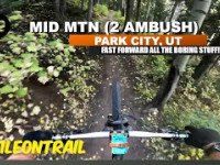
Mid Mountain Trail, starting at Silver Lake/Deer Valley through Park City Mountain Resort and then winds down through the Utah Olympic Park trail system to finish at the bottom of the Nordic jumps at the Utah Olympic Park. The course, rolling across the Wasatch Back through aspen and evergreen forests at an average elevation of 8,200′, is largely shaded single-track. The Mid Mountain Marathon embodies the essence of mountain trail running with intermittent technical sections, a few sustained climbs and fast downhills. Voted best trail marathon in Utah, the Mid Mountain Marathon is a true trail runner’s marathon and is part of the Triple Trail Challenge.

Mid Mountain Marathon Race info can be found at runttc.com

Detailed Description
Mid Mountain Marathon is a 26 mile less popular intermediate race route located near Park City Utah. This trail running primary route can be used one direction and has a moderate overall physical rating. This route includes 10 trails. This route climbs 2,538 ft with a max elevation of 8,505 ft then descends -3,813 ft.

Trail Issues on Route

  • Minor Issue / Yellow: 2 trails (newest: May 8, 2026)
Bike Park
Past Events

Stats

  • Distance
    26 miles
  • Avg time
    6 hr 42 min
  • Altitude change
    -1,275 ft
  • Altitude min
    6,790 ft
  • Altitude start
    8,138 ft
  • Altitude end
    6,864 ft
  • Climb
    2,538 ft
  • Descent
    -3,813 ft
  • Grade
    -0.9%
  • Grade max
    -42.9%
  • Grade min
    79.4%
  • Distance climb
    10 miles
  • Distance down
    14 miles
  • Distance flat
    2 miles

36 Reviews & Comments


We hope you've been enjoying Trailforks!

Create a FREE account to view route comments and much more.

Trails in Route

Route POI

Aid StationAid Station #1Aid Station
Aid StationAid Station #3Aid Station
Aid StationRestroom - Aid Station #4Aid Station
Aid StationRestrooms - Aid Station #5Aid Station
Aid StationAid Station #7Aid Station
Aid StationAid Station #8Aid Station
Aid StationAid Station #6Aid Station
Aid StationAid Station #2Aid Station

Details

  • Featured
  • Race Course
  • Riding area
  • Primary Activity
    Trail Running
  • Other Activities
    • Hike
  • Difficulty rating
    Blue
  • Route Type
    Point to Point
  • Direction
    One Direction
  • Physical rating
    Moderate
  • Ridelogs
    5

Directions

  1. Walk west on UOP Access.
  2. Continue for 40 meters.
  3. Turn left onto RTS Lower.
  4. Continue for 900 meters.
  5. Turn left onto Iron Bill.
  6. Continue for 1 kilometer.
  7. Turn left to stay on Iron Bill.
  8. Continue for 300 meters.
Avg: 1.65 (3 votes)
close
3D
Trail Conditions
  • Unknown
  • Snow Groomed
  • Snow Packed
  • Snow Covered
  • Snow Cover Partial
  • Freeze/thaw Cycle
  • Icy
  • Prevalent Mud
  • Wet
  • Variable
  • Ideal
  • Dry
  • Very Dry
Trail Flow (Ridden Direction)
Trailforks scans users ridelogs to determine the most popular direction each trail is ridden. A good flowing trail network will have most trails flowing in a single direction according to their intension.
The colour categories are based on what percentage of riders are riding a trail in its intended direction.
  • > 96%
  • > 90%
  • > 80%
  • > 70%
  • > 50%
  • < 50%
  • bi-directional trail
  • no data
Trail Last Ridden
Trailforks scans ridelogs to determine the last time a trail was ridden.
  • < 2 days
  • < 1 week
  • < 2 weeks
  • < 1 month
  • < 6 months
  • > 6 months
Trail Ridden Direction
The intended direction a trail should be ridden.
  • Downhill Only
  • Downhill Primary
  • Both Directions
  • Uphill Primary
  • Uphill Only
  • One Direction
Contribute Details
Colors indicate trail is missing specified detail.
  • Description
  • Photos
  • Description & Photos
  • Videos
Trail Popularity ?
Trailforks scans ridelogs to determine which trails are ridden the most in the last 9 months. Trails are compared with nearby trails in the same city region with a possible 25 colour shades. Think of this as a heatmap, more rides = more kinetic energy = warmer colors.
  • most popular
  • popular
  • less popular
  • not popular
ATV/ORV/OHV Filter
Max Vehicle Width
inches
US Cell Coverage
Legend
cell carrier legend

Radar Time
Activity Recordings
Trailforks uses anonymized public activity data. ?
Activity Recordings
Trailforks uses anonymized public activity data. ?
Personal Heatmap
Activity Types
all / none
Options
2
Date range month
Winter Trails
Warning A routing network for winter maps does not exist. Selecting trails using the winter trails layer has been disabled.
Missing Trails
Most Popular
Least Popular
Trails are colored based on popularity. The more popular a trail is, the more red. Less popular trails trend towards green.
Jump Magnitude Heatmap
Heatmap of where riders jump on trails. Zoom in to see individual jumps, click circles to view jump details.
BC Backroad Status

Service Road Atlas is a free to use, community-driven service for viewing and creating reports on the numerous back-country service roads around B.C. and Alberta.

map legend
Slope Aspect
Direction the slope faces
Flat N NE E SE S SW W NW
Trails Deemphasized
Trails are shown in grey.
disable
Only show trails with no bike usage.
Enable
Suggested Layers
Based on selected activity type

    Save the current map location and zoom level as your default home location whenever this page is loaded.

    Save
    Trail transparency
    • Singletrack
    • Unpaved
    290
    250
    208
    241

    Recent Trail Reports Along Route

    statustraildateconditiondescription
    Mid Mountain
    Jun 3, 2026 @ 9:46pm (America/Denver)
    Jun 3, 2026
    Open again!
    Moose Puddle
    Jun 1, 2026 @ 3:01pm (America/Denver)
    Jun 1, 2026
    Olympic
    Jun 1, 2026 @ 3:00pm (America/Denver)
    Jun 1, 2026
    Mid Mountain
    Jun 1, 2026 @ 3:00pm (America/Denver)
    Jun 1, 2026
    Mid Mountain
    Jun 1, 2026 @ 3:00pm (America/Denver)
    Jun 1, 2026
    more reports »
    • By toddTF Pro Trailforks & contributors
    • #3405 - 15,686 views

    Hit the Trail

    Open in App

    Get this route on your phone instantly.

    Download Route

    Save to wishlist, Garmin & download.