5.4 miles
Distance
503 ft
Climb
-513 ft
Descent
4,860 ft
High Point
-8 ft
Altitude change
4,397 ft
Altitude min
4,860 ft
Altitude start
4,852 ft
Altitude end
-24%
Grade max
22.3%
Grade min
3 miles
Distance climb
2 miles
Distance down
2,018 ft
Distance flat

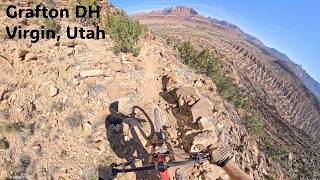
These are local, bootlegged trails that have a few doubleblack features. This route is fun to do after a loop around Wire Mesa. The trailhead is tricky to find and the trail can be hard to follow in places, but it's a fun challenge.

This route is Unsanctioned, Ride at your own Risk!

Detailed Description
Money Trails Loop is a 5 mile moderately popular extreme unsanctioned route located near Hurricane Utah. This mountain bike only route. This route includes 8 trails. This route climbs 503 ft with a max elevation of 4,860 ft then descends -513 ft.

Stats

  • Distance
    5 miles
  • Avg time
    1 hr 8 min
  • Altitude min
    4,397 ft
  • Altitude start
    4,860 ft
  • Altitude end
    4,852 ft
  • Climb
    503 ft
  • Descent
    -513 ft
  • Grade max
    -24%
  • Grade min
    22.3%
  • Distance climb
    3 miles
  • Distance down
    2 miles
  • Distance flat
    2,018 ft

38 Reviews & Comments


We hope you've been enjoying Trailforks!

Create a FREE account to view route comments and much more.

Details

  • Riding area
  • Primary Activity
    Mountain Bike
  • Difficulty rating
    Double Black Diamond
  • Route Type
    Loop
  • Bike type
    AM
  • Ridelogs
    7
no votes yet
close
3D
Trail Conditions
  • Unknown
  • Snow Groomed
  • Snow Packed
  • Snow Covered
  • Snow Cover Partial
  • Freeze/thaw Cycle
  • Icy
  • Prevalent Mud
  • Wet
  • Variable
  • Ideal
  • Dry
  • Very Dry
Trail Flow (Ridden Direction)
Trailforks scans users ridelogs to determine the most popular direction each trail is ridden. A good flowing trail network will have most trails flowing in a single direction according to their intension.
The colour categories are based on what percentage of riders are riding a trail in its intended direction.
  • > 96%
  • > 90%
  • > 80%
  • > 70%
  • > 50%
  • < 50%
  • bi-directional trail
  • no data
Trail Last Ridden
Trailforks scans ridelogs to determine the last time a trail was ridden.
  • < 2 days
  • < 1 week
  • < 2 weeks
  • < 1 month
  • < 6 months
  • > 6 months
Trail Ridden Direction
The intended direction a trail should be ridden.
  • Downhill Only
  • Downhill Primary
  • Both Directions
  • Uphill Primary
  • Uphill Only
  • One Direction
Contribute Details
Colors indicate trail is missing specified detail.
  • Description
  • Photos
  • Description & Photos
  • Videos
Trail Popularity ?
Trailforks scans ridelogs to determine which trails are ridden the most in the last 9 months. Trails are compared with nearby trails in the same city region with a possible 25 colour shades. Think of this as a heatmap, more rides = more kinetic energy = warmer colors.
  • most popular
  • popular
  • less popular
  • not popular
ATV/ORV/OHV Filter
Max Vehicle Width
inches
US Cell Coverage
Legend
cell carrier legend

Radar Time
Activity Recordings
Trailforks uses anonymized public activity data. ?
Activity Recordings
Trailforks uses anonymized public activity data. ?
Personal Heatmap
Activity Types
all / none
Options
2
Date range month
Winter Trails
Warning A routing network for winter maps does not exist. Selecting trails using the winter trails layer has been disabled.
Missing Trails
Most Popular
Least Popular
Trails are colored based on popularity. The more popular a trail is, the more red. Less popular trails trend towards green.
Jump Magnitude Heatmap
Heatmap of where riders jump on trails. Zoom in to see individual jumps, click circles to view jump details.
BC Backroad Status

Service Road Atlas is a free to use, community-driven service for viewing and creating reports on the numerous back-country service roads around B.C. and Alberta.

map legend
Slope Aspect
Direction the slope faces
Flat N NE E SE S SW W NW
Trails Deemphasized
Trails are shown in grey.
disable
Only show trails with no bike usage.
Enable
Suggested Layers
Based on selected activity type

    Save the current map location and zoom level as your default home location whenever this page is loaded.

    Save
    Trail transparency
    • Singletrack
    • Unpaved
    822
    862
    1,335
    1,199 | 3 faves
    Grafton Mesa DH | Virgin, Utah
    Grafton Mesa DH | Virgin, Utah
    3:47 | 52 | comments: 0 | favs:
    Apr 4, 2026
    Grafton Mesa  a Hurricane Classic, that...
    Grafton Mesa a Hurricane Classic, that doesn't disappoint!
    trail: More Money
    15:24 | 63 | comments: 0 | favs:
    Dec 18, 2025

    Recent Trail Reports Along Route

    statustraildateconditiondescription
    Grafton Mesa
    Apr 3, 2026 @ 12:16pm (America/Denver)
    Apr 3, 2026
    More Money
    Apr 3, 2026 @ 12:16pm (America/Denver)
    Apr 3, 2026
    Grafton Mesa road
    Feb 2, 2026 @ 11:08am (America/Denver)
    Feb 2, 2026
    Crazy dry for Feb.
    Show Me the Money
    Feb 2, 2026 @ 11:08am (America/Denver)
    Feb 2, 2026
    Crazy dry for Feb.
    County road access (Smithsonian Butte Rd)
    Dec 29, 2025 @ 6:58pm (America/Denver)
    Dec 29, 2025
    Great shape, damp, no mud and washboards aren’t bad
    more reports »
    • By twowheeledwandererTF Pro & contributors
    • #19179 - 2,256 views

    Hit the Trail

    Open in App

    Get this route on your phone instantly.

    Download Route

    Save to wishlist, Garmin & download.