

Open in App
Get this route on your phone instantly.
Shuttle Ride: leave a car at the South Elbert Trailhead, before starting the route at the Mount Massive parking lot.
Who doesn't want to ride off the highest peak in the Rocky Mountains
This route takes a shuttle approach to maximize the quality of singletrack, increase the downhill and most importantly make the climb a little less impossible.
The route begins at the Mount Massive parking lot, start out heading south on Colorado Trail Segment 11. The Colorado Trail starts with a warmup climb followed by perfect buffed single track, with a few speedy descents before meeting up with the South Mount Elbert trail. There were extensive trail realignments between 2017-2019, that now make the trail rideable on the climb up to the alpine. There is a fourth phase set to complete sometime in 2020, which will re-route a brutal section around 12,500'.
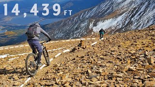
The hike a bike "Hikyling" starts at approx 13,000' and continues to the summit with just enough rideable sections sprinkled in to tease you.
Before embarking on one of the better descents in Colorado, catch your breath and take in the views from 14,433' you've earned it!
As for the descent its one to remember! Classic alpine tech until tree-line, where the rocks disappear and the single track nears perfection, buffed, fast and playful all the way to the South Elbert trailhead.
We hope you've been enjoying Trailforks!
Create a FREE account to view route comments and much more.
| 10 miles | |||||
| 1,306 ft |

Service Road Atlas is a free to use, community-driven service for viewing and creating reports on the numerous back-country service roads around B.C. and Alberta.
Save the current map location and zoom level as your default home location whenever this page is loaded.
Save