8.4 miles
Distance
706 ft
Climb
-705 ft
Descent
1 mile
High Point
1 ft
Altitude change
5,551 ft
Altitude min
5,551 ft
Altitude start
5,551 ft
Altitude end
-19.3%
Grade max
29%
Grade min
4 miles
Distance climb
4 miles
Distance down
4,367 ft
Distance flat

North Sky trail begins at the north end of the Dakota Ridge neighborhood and there's very limited parking on the street. If you aren't riding to this trail, you'll want to park at either the Fourmile Creek trailhead off of Lee Hill Road or the Eagle trailhead east of Hwy 36. This route starts at the Eagle trailhead.

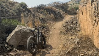
Begin your riding heading west through the underpass. You'll climb up Foothill trails - it's steep and rocky and not at all indicative of the North Sky trail (and this section of trail is slated for a reroute in 2025/2026). You'll got under the bridge, turn left, and follow the clover leaf to cross the bridge and get to North Sky.

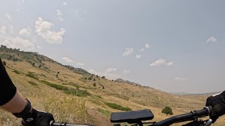
North Sky is a beginner-friendly trail that parallels Highway 36 to Joder Ranch. It undulates the entire 3.5 miles without a lot of climbing. At Joder Ranch, you can turn around and retrace your steps (as is routed here) or cross Highway 36 and return through Boulder Valley Ranch.

Detailed Description
North Sky is a 8 mile popular easy route located near Boulder Colorado. This mountain bike primary route can be used both directions and has a moderate overall physical rating. This route includes 2 trails. This route climbs 706 ft with a max elevation of 5,799 ft then descends -705 ft.
Local Trail Association
Local trail association
International Mountain Bicycling Association (IMBA) (www.imba.com)
Please consider joining or donating to the local riding association to support trail development & maintenance.
Donate to earn trail karma!

Stats

  • Distance
    8 miles
  • Altitude min
    5,551 ft
  • Altitude start
    5,551 ft
  • Altitude end
    5,551 ft
  • Climb
    706 ft
  • Descent
    -705 ft
  • Grade max
    -19.3%
  • Grade min
    29%
  • Distance climb
    4 miles
  • Distance down
    4 miles
  • Distance flat
    4,367 ft

1 Review & Comments


We hope you've been enjoying Trailforks!

Create a FREE account to view route comments and much more.

Trails in Route

Details

  • Featured
  • Riding area
  • Primary Activity
    Mountain Bike
  • Other Activities
    • Gravel Bike
    • Horse
    • Hike
    • Trail Running
  • Difficulty rating
    Green
  • Route Type
    Out & Back
  • eBike Allowed
  • Bike type
  • Direction
    Both Directions
  • Physical rating
    Moderate

Directions

  1. Walk west on Foothills - North.
  2. Continue for 800 meters.
  3. Keep left to stay on Foothills - North.
  4. Continue for 20 meters.
  5. Make a sharp right onto North Sky Trail.
  6. Continue for 20 meters.
  7. Bear left onto Foothills - North.
  8. Continue for 30 meters.
  9. Keep right to stay on Foothills - North.
  10. Continue for 10 meters.
  11. Turn left onto North Sky Trail.
  12. Continue for 20 meters.
  13. Keep left to stay on North Sky Trail.
  14. Continue for 80 meters.
  15. Keep left to take Foothills Bench.
  16. Continue for 10 meters.
  17. Keep left to take North Sky Trail.
  18. Continue for 80 meters.
  19. Keep right to stay on North Sky Trail.
  20. Continue for less than 10 meters.
  21. Keep left to stay on North Sky Trail.
  22. Continue for 20 meters.
  23. Keep right to stay on North Sky Trail.
  24. Continue for 70 meters.
  25. Keep right to take Foothills Bench.
  26. Continue for 40 meters.
  27. Keep left to stay on Foothills Bench.
  28. Continue for less than 10 meters.
  29. Keep left to take North Sky Trail.
  30. Continue for 20 meters.
  31. Keep left to take Foothills Bench.
  32. Continue for 30 meters.
  33. Keep left to take North Sky Trail.
  34. Continue for 200 meters.
  35. Keep left to take Foothills Bench.
  36. Continue for 10 meters.
  37. Keep right to stay on Foothills Bench.
  38. Continue for 100 meters.
  39. Keep right to take North Sky Trail.
  40. Continue for less than 10 meters.
  41. Keep right to take Foothills Bench.
  42. Continue for 80 meters.
  43. Keep left to stay on Foothills Bench.
  44. Continue for 20 meters.
  45. Keep right to stay on Foothills Bench.
  46. Continue for 100 meters.
  47. Keep right to take North Sky Trail.
  48. Continue for 60 meters.
  49. Keep left to stay on North Sky Trail.
  50. Continue for 40 meters.
  51. Keep left to take Foothills Bench.
  52. Continue for 40 meters.
  53. Keep left to take North Sky Trail.
  54. Continue for less than 10 meters.
  55. Keep right to stay on North Sky Trail.
  56. Continue for 30 meters.
  57. Keep left to stay on North Sky Trail.
  58. Continue for 10 meters.
  59. Keep right to stay on North Sky Trail.
  60. Continue for 20 meters.
  61. Keep right to take Foothills Bench.
  62. Continue for 70 meters.
  63. Keep left to take North Sky Trail.
  64. Continue for 20 meters.
  65. Keep right to stay on North Sky Trail.
  66. Continue for 10 meters.
  67. Keep left to stay on North Sky Trail.
  68. Continue for 300 meters.
  69. Turn right to stay on North Sky Trail.
  70. Continue for 700 meters.
  71. Keep left to stay on North Sky Trail.
  72. Continue for 900 meters.
  73. Keep left to take Foothills Bench.
  74. Continue for 20 meters.
  75. Keep left to take North Sky Trail.
  76. Continue for 3 kilometers.
  77. Walk southeast on North Sky Trail.
  78. Continue for 2.5 kilometers.
  79. Keep right to take Foothills Bench.
  80. Continue for 20 meters.
  81. Keep right to take North Sky Trail.
  82. Continue for 900 meters.
  83. Keep left to stay on North Sky Trail.
  84. Continue for 700 meters.
  85. Turn left to stay on North Sky Trail.
  86. Continue for 300 meters.
  87. Keep left to stay on North Sky Trail.
  88. Continue for 10 meters.
  89. Keep right to stay on North Sky Trail.
  90. Continue for 20 meters.
  91. Keep left to take Foothills Bench.
  92. Continue for 70 meters.
  93. Keep right to stay on Foothills Bench.
  94. Continue for 20 meters.
  95. Keep right to take North Sky Trail.
  96. Continue for 10 meters.
  97. Keep right to take Foothills Bench.
  98. Continue for 40 meters.
  99. Keep right to take North Sky Trail.
  100. Continue for less than 10 meters.
  101. Keep left to stay on North Sky Trail.
  102. Continue for 40 meters.
  103. Keep right to stay on North Sky Trail.
  104. Continue for 40 meters.
  105. Keep left to stay on North Sky Trail.
  106. Continue for 60 meters.
  107. Keep left to take Foothills Bench.
  108. Continue for 100 meters.
  109. Keep right to stay on Foothills Bench.
  110. Continue for 20 meters.
  111. Keep left to stay on Foothills Bench.
  112. Continue for 80 meters.
  113. Keep left to take North Sky Trail.
  114. Continue for less than 10 meters.
  115. Keep left to take Foothills Bench.
  116. Continue for 100 meters.
  117. Keep left to take North Sky Trail.
  118. Continue for 10 meters.
  119. Keep right to stay on North Sky Trail.
  120. Continue for 200 meters.
  121. Keep left to stay on North Sky Trail.
  122. Continue for 30 meters.
  123. Keep left to take Foothills Bench.
  124. Continue for 20 meters.
  125. Keep right to stay on Foothills Bench.
  126. Continue for less than 10 meters.
  127. Keep left to stay on Foothills Bench.
  128. Continue for 40 meters.
  129. Keep left to take North Sky Trail.
  130. Continue for 70 meters.
  131. Keep right to stay on North Sky Trail.
  132. Continue for 20 meters.
  133. Keep right to stay on North Sky Trail.
  134. Continue for less than 10 meters.
  135. Keep right to stay on North Sky Trail.
  136. Continue for 80 meters.
  137. Keep right to take Foothills Bench.
  138. Continue for 10 meters.
  139. Keep right to take North Sky Trail.
  140. Continue for 80 meters.
  141. Keep straight to stay on North Sky Trail.
  142. Continue for 100 meters.
  143. Turn right onto Foothills - North.
  144. Continue for 30 meters.
  145. Keep right to stay on Foothills - North.
  146. Continue for 800 meters.
no votes yet
close
3D
Trail Conditions
  • Unknown
  • Snow Groomed
  • Snow Packed
  • Snow Covered
  • Snow Cover Partial
  • Freeze/thaw Cycle
  • Icy
  • Prevalent Mud
  • Wet
  • Variable
  • Ideal
  • Dry
  • Very Dry
Trail Flow (Ridden Direction)
Trailforks scans users ridelogs to determine the most popular direction each trail is ridden. A good flowing trail network will have most trails flowing in a single direction according to their intension.
The colour categories are based on what percentage of riders are riding a trail in its intended direction.
  • > 96%
  • > 90%
  • > 80%
  • > 70%
  • > 50%
  • < 50%
  • bi-directional trail
  • no data
Trail Last Ridden
Trailforks scans ridelogs to determine the last time a trail was ridden.
  • < 2 days
  • < 1 week
  • < 2 weeks
  • < 1 month
  • < 6 months
  • > 6 months
Trail Ridden Direction
The intended direction a trail should be ridden.
  • Downhill Only
  • Downhill Primary
  • Both Directions
  • Uphill Primary
  • Uphill Only
  • One Direction
Contribute Details
Colors indicate trail is missing specified detail.
  • Description
  • Photos
  • Description & Photos
  • Videos
Trail Popularity ?
Trailforks scans ridelogs to determine which trails are ridden the most in the last 9 months. Trails are compared with nearby trails in the same city region with a possible 25 colour shades. Think of this as a heatmap, more rides = more kinetic energy = warmer colors.
  • most popular
  • popular
  • less popular
  • not popular
ATV/ORV/OHV Filter
Max Vehicle Width
inches
US Cell Coverage
Legend
cell carrier legend

Radar Time
Activity Recordings
Trailforks uses anonymized public activity data. ?
Activity Recordings
Trailforks uses anonymized public activity data. ?
Personal Heatmap
Activity Types
all / none
Options
2
Date range month
Winter Trails
Warning A routing network for winter maps does not exist. Selecting trails using the winter trails layer has been disabled.
Missing Trails
Most Popular
Least Popular
Trails are colored based on popularity. The more popular a trail is, the more red. Less popular trails trend towards green.
Jump Magnitude Heatmap
Heatmap of where riders jump on trails. Zoom in to see individual jumps, click circles to view jump details.
BC Backroad Status

Service Road Atlas is a free to use, community-driven service for viewing and creating reports on the numerous back-country service roads around B.C. and Alberta.

map legend
Slope Aspect
Direction the slope faces
Flat N NE E SE S SW W NW
Trails Deemphasized
Trails are shown in grey.
disable
Only show trails with no bike usage.
Enable
Suggested Layers
Based on selected activity type

    Save the current map location and zoom level as your default home location whenever this page is loaded.

    Save
    Trail transparency
    • Singletrack
    14
    18
    25
    140
    The Fat Boy loves North Sky Trail - Boulder -...
    The Fat Boy loves North Sky Trail - Boulder - Colorado
    4:06 | 289 | comments: 0 | favs:
    Jul 27, 2024
    North Sky - New Green Flow in Boulder! - Colorado
    North Sky - New Green Flow in Boulder! - Colorado
    7:05 | 154 | comments: 0 | favs:
    Jul 22, 2024

    Recent Trail Reports Along Route

    statustraildateconditiondescription
    North Sky Trail
    May 22, 2026 @ 5:23pm (America/Denver)
    May 22, 2026
    Trail is open. Please update conditions if you ride reporter
    more reports »
    • By WendyBMATF Pro BMA & contributors
    • #58915 - 1,072 views

    Hit the Trail

    Open in App

    Get this route on your phone instantly.

    Download Route

    Save to wishlist, Garmin & download.