5.7 miles
Distance
460 ft
Climb
-451 ft
Descent
4,388 ft
High Point
9 ft
Altitude change
4,161 ft
Altitude min
4,330 ft
Altitude start
4,341 ft
Altitude end
-19.5%
Grade max
18.4%
Grade min
2 miles
Distance climb
2 miles
Distance down
1 mile
Distance flat

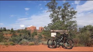
This fast and fun lap is perfect for a quick ride whether you are a beginner or advanced rider. From the Courthouse Vista trailhead, head down Bell Rock Pathway's double track to the Single Track Bypass. This fast spur lets you warm up your cornering skills while avoiding hikers on BRP. Hit the Big Park Loop intersection and head East. We recommend taking the loop counter-clockwise for the most flow, but it can be ridden either direction. BPL starts off with some flowy XC riding and throws in a short armored downhill section towards the end. Take BRP back to the Trailhead.

Detailed Description
Village of Oak Creek 1 is a 6 mile moderately popular easy route located near Village Of Oak Creek Arizona. This mountain bike primary route can be used both directions and has a easy overall physical rating. This route includes 8 trails. This route climbs 460 ft with a max elevation of 4,388 ft then descends -451 ft.
Local Trail Association
Please consider joining or donating to the local riding association to support trail development & maintenance.
Donate to earn trail karma!

Stats

  • Distance
    6 miles
  • Avg time
    1 hr 23 min
  • Altitude min
    4,161 ft
  • Altitude start
    4,330 ft
  • Altitude end
    4,341 ft
  • Climb
    460 ft
  • Descent
    -451 ft
  • Grade max
    -19.5%
  • Grade min
    18.4%
  • Distance climb
    2 miles
  • Distance down
    2 miles
  • Distance flat
    1 mile

27 Reviews & Comments


We hope you've been enjoying Trailforks!

Create a FREE account to view route comments and much more.

Trails in Route

Details

  • Riding area
  • Primary Activity
    Mountain Bike
  • Other Activities
    • Horse
    • Hike
  • Difficulty rating
    Green
  • Route Type
    Loop
  • eBike Allowed
  • Bike type
    AM, XC
  • Direction
    Both Directions
  • Physical rating
    Easy
  • Ridelogs
    18
Avg: 1 (1 votes)
close
3D
Trail Conditions
  • Unknown
  • Snow Groomed
  • Snow Packed
  • Snow Covered
  • Snow Cover Partial
  • Freeze/thaw Cycle
  • Icy
  • Prevalent Mud
  • Wet
  • Variable
  • Ideal
  • Dry
  • Very Dry
Trail Flow (Ridden Direction)
Trailforks scans users ridelogs to determine the most popular direction each trail is ridden. A good flowing trail network will have most trails flowing in a single direction according to their intension.
The colour categories are based on what percentage of riders are riding a trail in its intended direction.
  • > 96%
  • > 90%
  • > 80%
  • > 70%
  • > 50%
  • < 50%
  • bi-directional trail
  • no data
Trail Last Ridden
Trailforks scans ridelogs to determine the last time a trail was ridden.
  • < 2 days
  • < 1 week
  • < 2 weeks
  • < 1 month
  • < 6 months
  • > 6 months
Trail Ridden Direction
The intended direction a trail should be ridden.
  • Downhill Only
  • Downhill Primary
  • Both Directions
  • Uphill Primary
  • Uphill Only
  • One Direction
Contribute Details
Colors indicate trail is missing specified detail.
  • Description
  • Photos
  • Description & Photos
  • Videos
Trail Popularity ?
Trailforks scans ridelogs to determine which trails are ridden the most in the last 9 months. Trails are compared with nearby trails in the same city region with a possible 25 colour shades. Think of this as a heatmap, more rides = more kinetic energy = warmer colors.
  • most popular
  • popular
  • less popular
  • not popular
ATV/ORV/OHV Filter
Max Vehicle Width
inches
US Cell Coverage
Legend
cell carrier legend

Radar Time
Activity Recordings
Trailforks uses anonymized public activity data. ?
Activity Recordings
Trailforks uses anonymized public activity data. ?
Personal Heatmap
Activity Types
all / none
Options
2
Date range month
Winter Trails
Warning A routing network for winter maps does not exist. Selecting trails using the winter trails layer has been disabled.
Missing Trails
Most Popular
Least Popular
Trails are colored based on popularity. The more popular a trail is, the more red. Less popular trails trend towards green.
Jump Magnitude Heatmap
Heatmap of where riders jump on trails. Zoom in to see individual jumps, click circles to view jump details.
BC Backroad Status

Service Road Atlas is a free to use, community-driven service for viewing and creating reports on the numerous back-country service roads around B.C. and Alberta.

map legend
Slope Aspect
Direction the slope faces
Flat N NE E SE S SW W NW
Trails Deemphasized
Trails are shown in grey.
disable
Only show trails with no bike usage.
Enable
Suggested Layers
Based on selected activity type

    Save the current map location and zoom level as your default home location whenever this page is loaded.

    Save
    Trail transparency
    • Singletrack
    41
    384
    365
    532
    #flashbackfriday Riding in Sedona, AZ✌️
    #flashbackfriday Riding in Sedona, AZ✌️
    4:23 | 157 | comments: 0 | favs:
    Jun 21, 2024
    First Time in Sedona: Bell Rock Trails
    First Time in Sedona: Bell Rock Trails
    trail: Phone
    15:01 | 178 | comments: 0 | favs:
    May 13, 2024

    Recent Trail Reports Along Route

    statustraildateconditiondescription
    Big Park Loop
    Jun 8, 2026 @ 8:13am (America/Phoenix)
    Jun 8, 2026
    Singletrack Bypass
    Apr 3, 2026 @ 3:23pm (America/Phoenix)
    Apr 3, 2026
    Phone
    Apr 3, 2026 @ 3:23pm (America/Phoenix)
    Apr 3, 2026
    Big Park Loop
    Feb 27, 2026 @ 10:30am (America/Phoenix)
    Feb 27, 2026
    Bell Rock Pathway
    Jan 22, 2026 @ 3:39pm (America/Phoenix)
    Jan 22, 2026
    more reports »
    • By MollyJoyceTF Pro & contributors
    • #17599 - 1,290 views

    Hit the Trail

    Open in App

    Get this route on your phone instantly.

    Download Route

    Save to wishlist, Garmin & download.