5.3 miles
Distance
649 ft
Climb
-682 ft
Descent
4,541 ft
High Point
-33 ft
Altitude change
4,204 ft
Altitude min
4,372 ft
Altitude start
4,337 ft
Altitude end
-0.1%
Grade
-21.2%
Grade max
22.7%
Grade min
2 miles
Distance climb
2 miles
Distance down
2,959 ft
Distance flat

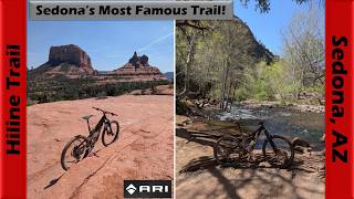
If you're still not sure if you want to take on Hiline, try this loop first. From the Yavapai Vista parking lot, climb Kaibab to Yavapai to gain the high point of Slim Shady. Head south and descend Slim Shady to the Made in the Shade intersection. Climb up this black diamond trail for some glimpses of Sedona exposure and technical climbing look like. If you feel solid on this then you'll be good for Hiline. Descend the slick rock back to Slim Shady and hang a left to head back north on Slim. End the ride here at Yavapai or continue down the north side of Slim Shady, rally through the rock gardens and find your flow through one of the most fun downhills in Sedona. Take Templeton and Easy Breezy back to Hermit and to the parking lot.

Detailed Description
Village of Oak Creek 5 is a 5 mile moderately popular expert route located near Village Of Oak Creek Arizona. This mountain bike primary route can be used one direction and has a hard overall physical rating. This route includes 12 trails. This route climbs 649 ft with a max elevation of 4,541 ft then descends -682 ft.
Local Trail Association
Please consider joining or donating to the local riding association to support trail development & maintenance.
Donate to earn trail karma!

Stats

  • Distance
    5 miles
  • Avg time
    1 hr 18 min
  • Altitude min
    4,204 ft
  • Altitude start
    4,372 ft
  • Altitude end
    4,337 ft
  • Climb
    649 ft
  • Descent
    -682 ft
  • Grade
    -0.1%
  • Grade max
    -21.2%
  • Grade min
    22.7%
  • Distance climb
    2 miles
  • Distance down
    2 miles
  • Distance flat
    2,959 ft

49 Reviews & Comments


We hope you've been enjoying Trailforks!

Create a FREE account to view route comments and much more.

Trails in Route

Details

  • Riding area
  • Primary Activity
    Mountain Bike
  • Other Activities
    • Horse
    • Hike
    • Trail Running
  • Difficulty rating
    Black Diamond
  • Route Type
    Loop
  • eBike Allowed
  • Bike type
    AM, XC
  • Direction
    One Direction
  • Physical rating
    Hard
  • Ridelogs
    17
no votes yet
close
3D
Trail Conditions
  • Unknown
  • Snow Groomed
  • Snow Packed
  • Snow Covered
  • Snow Cover Partial
  • Freeze/thaw Cycle
  • Icy
  • Prevalent Mud
  • Wet
  • Variable
  • Ideal
  • Dry
  • Very Dry
Trail Flow (Ridden Direction)
Trailforks scans users ridelogs to determine the most popular direction each trail is ridden. A good flowing trail network will have most trails flowing in a single direction according to their intension.
The colour categories are based on what percentage of riders are riding a trail in its intended direction.
  • > 96%
  • > 90%
  • > 80%
  • > 70%
  • > 50%
  • < 50%
  • bi-directional trail
  • no data
Trail Last Ridden
Trailforks scans ridelogs to determine the last time a trail was ridden.
  • < 2 days
  • < 1 week
  • < 2 weeks
  • < 1 month
  • < 6 months
  • > 6 months
Trail Ridden Direction
The intended direction a trail should be ridden.
  • Downhill Only
  • Downhill Primary
  • Both Directions
  • Uphill Primary
  • Uphill Only
  • One Direction
Contribute Details
Colors indicate trail is missing specified detail.
  • Description
  • Photos
  • Description & Photos
  • Videos
Trail Popularity ?
Trailforks scans ridelogs to determine which trails are ridden the most in the last 9 months. Trails are compared with nearby trails in the same city region with a possible 25 colour shades. Think of this as a heatmap, more rides = more kinetic energy = warmer colors.
  • most popular
  • popular
  • less popular
  • not popular
ATV/ORV/OHV Filter
Max Vehicle Width
inches
US Cell Coverage
Legend
cell carrier legend

Radar Time
Activity Recordings
Trailforks uses anonymized public activity data. ?
Activity Recordings
Trailforks uses anonymized public activity data. ?
Personal Heatmap
Activity Types
all / none
Options
2
Date range month
Winter Trails
Warning A routing network for winter maps does not exist. Selecting trails using the winter trails layer has been disabled.
Missing Trails
Most Popular
Least Popular
Trails are colored based on popularity. The more popular a trail is, the more red. Less popular trails trend towards green.
Jump Magnitude Heatmap
Heatmap of where riders jump on trails. Zoom in to see individual jumps, click circles to view jump details.
BC Backroad Status

Service Road Atlas is a free to use, community-driven service for viewing and creating reports on the numerous back-country service roads around B.C. and Alberta.

map legend
Slope Aspect
Direction the slope faces
Flat N NE E SE S SW W NW
Trails Deemphasized
Trails are shown in grey.
disable
Only show trails with no bike usage.
Enable
Suggested Layers
Based on selected activity type

    Save the current map location and zoom level as your default home location whenever this page is loaded.

    Save
    Trail transparency
    • Singletrack
    303
    285
    1,496 | 1 faves
    414
    Riding Slim Shady North - Sedona, AZ
    Riding Slim Shady North - Sedona, AZ
    118 | comments: 0 | favs:
    Jun 10, 2025

    Recent Trail Reports Along Route

    statustraildateconditiondescription
    Hermit
    May 23, 2026 @ 9:42am (America/Phoenix)
    May 23, 2026
    Kaibab
    May 23, 2026 @ 9:42am (America/Phoenix)
    May 23, 2026
    Yavapai Point
    May 23, 2026 @ 9:42am (America/Phoenix)
    May 23, 2026
    Coconino
    Apr 3, 2026 @ 3:23pm (America/Phoenix)
    Apr 3, 2026
    Templeton
    Mar 14, 2026 @ 9:04am (America/Phoenix)
    Mar 14, 2026
    more reports »
    • By MollyJoyceTF Pro & contributors
    • #17603 - 810 views

    Hit the Trail

    Open in App

    Get this route on your phone instantly.

    Download Route

    Save to wishlist, Garmin & download.