25.7 miles
Distance
5,268 ft
Climb
-5,266 ft
Descent
2,729 ft
High Point
3 ft
Altitude change
394 ft
Altitude min
394 ft
Altitude start
397 ft
Altitude end
-54.5%
Grade max
45.8%
Grade min
12 miles
Distance climb
12 miles
Distance down
1 mile
Distance flat

I am not responsible for any injuries, or incidents. Ride at your own risk!

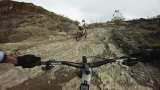
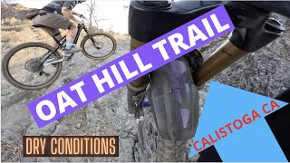
A great place to practice some basic, all the way to advanced MTB skills, before races, or just to stay in shape. It is rough, and expect to find some technical terrain

Detailed Description
Oat Mine Loop is a 26 mile popular expert route located near Calistoga California. This mountain bike only route. This route includes 6 trails. This route climbs 5,268 ft with a max elevation of 2,729 ft then descends -5,266 ft.

Trail Issues on Route

  • Minor Issue / Yellow: 1 trail (newest: Jun 14, 2021)
Local Trail Association
Please consider joining or donating to the local riding association to support trail development & maintenance.
Donate to earn trail karma!

Stats

  • Distance
    26 miles
  • Avg time
    2 hr 56 min
  • Altitude min
    394 ft
  • Altitude start
    394 ft
  • Altitude end
    397 ft
  • Climb
    5,268 ft
  • Descent
    -5,266 ft
  • Grade max
    -54.5%
  • Grade min
    45.8%
  • Distance climb
    12 miles
  • Distance down
    12 miles
  • Distance flat
    1 mile

16 Reviews & Comments


We hope you've been enjoying Trailforks!

Create a FREE account to view route comments and much more.

Trails in Route

Details

  • Riding area
  • Primary Activity
    Mountain Bike
  • Difficulty rating
    Black Diamond
  • Route Type
    Out & Back
  • Bike type
    DH, AM
  • Ridelogs
    4
Avg: 4.5 (2 votes)
close
3D
Trail Conditions
  • Unknown
  • Snow Groomed
  • Snow Packed
  • Snow Covered
  • Snow Cover Partial
  • Freeze/thaw Cycle
  • Icy
  • Prevalent Mud
  • Wet
  • Variable
  • Ideal
  • Dry
  • Very Dry
Trail Flow (Ridden Direction)
Trailforks scans users ridelogs to determine the most popular direction each trail is ridden. A good flowing trail network will have most trails flowing in a single direction according to their intension.
The colour categories are based on what percentage of riders are riding a trail in its intended direction.
  • > 96%
  • > 90%
  • > 80%
  • > 70%
  • > 50%
  • < 50%
  • bi-directional trail
  • no data
Trail Last Ridden
Trailforks scans ridelogs to determine the last time a trail was ridden.
  • < 2 days
  • < 1 week
  • < 2 weeks
  • < 1 month
  • < 6 months
  • > 6 months
Trail Ridden Direction
The intended direction a trail should be ridden.
  • Downhill Only
  • Downhill Primary
  • Both Directions
  • Uphill Primary
  • Uphill Only
  • One Direction
Contribute Details
Colors indicate trail is missing specified detail.
  • Description
  • Photos
  • Description & Photos
  • Videos
Trail Popularity ?
Trailforks scans ridelogs to determine which trails are ridden the most in the last 9 months. Trails are compared with nearby trails in the same city region with a possible 25 colour shades. Think of this as a heatmap, more rides = more kinetic energy = warmer colors.
  • most popular
  • popular
  • less popular
  • not popular
ATV/ORV/OHV Filter
Max Vehicle Width
inches
US Cell Coverage
Legend
cell carrier legend

Radar Time
Activity Recordings
Trailforks uses anonymized public activity data. ?
Activity Recordings
Trailforks uses anonymized public activity data. ?
Personal Heatmap
Activity Types
all / none
Options
2
Date range month
Winter Trails
Warning A routing network for winter maps does not exist. Selecting trails using the winter trails layer has been disabled.
Missing Trails
Most Popular
Least Popular
Trails are colored based on popularity. The more popular a trail is, the more red. Less popular trails trend towards green.
Jump Magnitude Heatmap
Heatmap of where riders jump on trails. Zoom in to see individual jumps, click circles to view jump details.
BC Backroad Status

Service Road Atlas is a free to use, community-driven service for viewing and creating reports on the numerous back-country service roads around B.C. and Alberta.

map legend
Slope Aspect
Direction the slope faces
Flat N NE E SE S SW W NW
Trails Deemphasized
Trails are shown in grey.
disable
Only show trails with no bike usage.
Enable
Suggested Layers
Based on selected activity type

    Save the current map location and zoom level as your default home location whenever this page is loaded.

    Save
    Trail transparency
    • Singletrack
    • Unpaved
    157
    156
    152
    174
    Joy of Climbing
    Joy of Climbing
    4:57 | 53 | comments: 0 | favs:
    Oct 27, 2025
    Riding Oat Hill in The Summer
    Riding Oat Hill in The Summer
    13:21 | 209 | comments: 0 | favs:
    May 1, 2023

    Recent Trail Reports Along Route

    statustraildateconditiondescription
    Oat Hill Mine
    Mar 30, 2025 @ 11:19am
    Mar 30, 2025
    Trail was clear and 99% dry.
    Hoffnagle Loop
    Sep 17, 2024 @ 9:52am
    Sep 17, 2024
    Duff Ranch
    Sep 17, 2024 @ 9:52am
    Sep 17, 2024
    Hoffnagle Loop
    Jun 14, 2021 @ 9:32am
    Jun 14, 2021
    The fire road is really overgrown. Lots of spiky plants and burrs to whip your shins the entire way down and stick to your socks and shoes.
    more reports »
    • By JacobyDH & contributors
    • #18261 - 2,318 views

    Hit the Trail

    Open in App

    Get this route on your phone instantly.

    Download Route

    Save to wishlist, Garmin & download.