11.8 miles
Distance
1,669 ft
Climb
-5,254 ft
Descent
3,621 ft
High Point
-3,586 ft
Altitude change
24 ft
Altitude min
3,621 ft
Altitude start
36 ft
Altitude end
-5.7%
Grade
-92.2%
Grade max
69.6%
Grade min
4 miles
Distance climb
7 miles
Distance down
4,777 ft
Distance flat

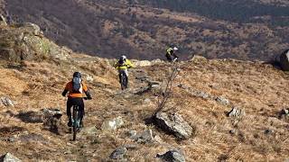
Tour possibile con prenotazione Shuttle o possibile salita con EBike

Prima parte impegnativa, con trail Pigo trail con panorami incredibili,
raccordo su Nascio Up, toboga che raccorda ad una parte di asfalto che riconduce a parte dell'anello CogoletOOutdoor con trails molto vari e con differenti livelli di difficoltà

Detailed Description
Pigo Tour is a 12 mile popular expert route located near Cogoleto. This mountain bike only route can be used one direction and has a hard overall physical rating. This route includes 12 trails. This route climbs 1,669 ft with a max elevation of 3,621 ft then descends -5,254 ft.

Trail Issues on Route

  • Significant Issue / Amber: 1 trail (newest: May 19, 2026)
Local Trail Association
Local trail association
ASD CogoletOOutdoor
Please consider joining or donating to the local riding association to support trail development & maintenance.
Donate to earn trail karma!

Stats

  • Distance
    12 miles
  • Avg time
    3 hr 17 min
  • Altitude change
    -3,586 ft
  • Altitude min
    24 ft
  • Altitude start
    3,621 ft
  • Altitude end
    36 ft
  • Climb
    1,669 ft
  • Descent
    -5,254 ft
  • Grade
    -5.7%
  • Grade max
    -92.2%
  • Grade min
    69.6%
  • Distance climb
    4 miles
  • Distance down
    7 miles
  • Distance flat
    4,777 ft

24 Reviews & Comments


We hope you've been enjoying Trailforks!

Create a FREE account to view route comments and much more.

Trails in Route

Pigo2 miles
Nascio Alto3,399 ft
Garescio3,937 ft
Curletti696 ft
Uguale Rosso2,543 ft
S.Anna
Loaga
Balledoro2,615 ft
Scoglio A1,591 ft

Details

  • Riding area
  • Primary Activity
    Mountain Bike
  • Difficulty rating
    Black Diamond
  • Route Type
    Shuttled
  • eBike Allowed
  • Bike type
    DH, AM
  • Direction
    One Direction
  • Physical rating
    Hard
Avg: 5 (1 votes)
close
3D
Trail Conditions
  • Unknown
  • Snow Groomed
  • Snow Packed
  • Snow Covered
  • Snow Cover Partial
  • Freeze/thaw Cycle
  • Icy
  • Prevalent Mud
  • Wet
  • Variable
  • Ideal
  • Dry
  • Very Dry
Trail Flow (Ridden Direction)
Trailforks scans users ridelogs to determine the most popular direction each trail is ridden. A good flowing trail network will have most trails flowing in a single direction according to their intension.
The colour categories are based on what percentage of riders are riding a trail in its intended direction.
  • > 96%
  • > 90%
  • > 80%
  • > 70%
  • > 50%
  • < 50%
  • bi-directional trail
  • no data
Trail Last Ridden
Trailforks scans ridelogs to determine the last time a trail was ridden.
  • < 2 days
  • < 1 week
  • < 2 weeks
  • < 1 month
  • < 6 months
  • > 6 months
Trail Ridden Direction
The intended direction a trail should be ridden.
  • Downhill Only
  • Downhill Primary
  • Both Directions
  • Uphill Primary
  • Uphill Only
  • One Direction
Contribute Details
Colors indicate trail is missing specified detail.
  • Description
  • Photos
  • Description & Photos
  • Videos
Trail Popularity ?
Trailforks scans ridelogs to determine which trails are ridden the most in the last 9 months. Trails are compared with nearby trails in the same city region with a possible 25 colour shades. Think of this as a heatmap, more rides = more kinetic energy = warmer colors.
  • most popular
  • popular
  • less popular
  • not popular
ATV/ORV/OHV Filter
Max Vehicle Width
inches
US Cell Coverage
Legend
cell carrier legend

Radar Time
Activity Recordings
Trailforks uses anonymized public activity data. ?
Activity Recordings
Trailforks uses anonymized public activity data. ?
Personal Heatmap
Activity Types
all / none
Options
2
Date range month
Winter Trails
Warning A routing network for winter maps does not exist. Selecting trails using the winter trails layer has been disabled.
Missing Trails
Most Popular
Least Popular
Trails are colored based on popularity. The more popular a trail is, the more red. Less popular trails trend towards green.
Jump Magnitude Heatmap
Heatmap of where riders jump on trails. Zoom in to see individual jumps, click circles to view jump details.
BC Backroad Status

Service Road Atlas is a free to use, community-driven service for viewing and creating reports on the numerous back-country service roads around B.C. and Alberta.

map legend
Slope Aspect
Direction the slope faces
Flat N NE E SE S SW W NW
Trails Deemphasized
Trails are shown in grey.
disable
Only show trails with no bike usage.
Enable
Suggested Layers
Based on selected activity type

    Save the current map location and zoom level as your default home location whenever this page is loaded.

    Save
    Trail transparency
    • Singletrack
    • Unpaved
    136
    123
    147
    115
    Pigo Trail - Parco del Beigua, Liguria. La...
    Pigo Trail - Parco del Beigua, Liguria. La Montagna in Bicicletta.
    trail: Pigo
    15:13 | 23 | comments: 0 | favs:
    Apr 29, 2026
    vttae en Ligurie, trail Pigo, Monte Beigua
    vttae en Ligurie, trail Pigo, Monte Beigua
    trail: Pigo
    4:31 | 449 | comments: 0 | favs:
    Apr 24, 2023

    Recent Trail Reports Along Route

    statustraildateconditiondescription
    Loaga
    Jun 16, 2026 @ 8:38am (Europe/Rome)
    Jun 15, 2026
    ok si percorre senza problemi solo un po di erba alta.
    Scoglio A
    Jun 16, 2026 @ 8:32am (Europe/Rome)
    Jun 15, 2026
    buono , sentiero corto ma divertente , solo un po di vegetazione che nasconde in parte il sentiero
    Nascio Alto
    Jun 11, 2026 @ 5:56pm (Europe/Monaco)
    Jun 11, 2026
    Trail sempre perfetto
    Pigo
    May 19, 2026 @ 9:16am (Europe/Rome)
    May 19, 2026
    abbandonato e devastato dall'acqua, da evitare
    Curletti
    Apr 22, 2026 @ 11:09pm (Europe/Rome)
    Apr 22, 2026
    more reports »
    • By ELuca & contributors
    • #44657 - 993 views

    Hit the Trail

    Open in App

    Get this route on your phone instantly.

    Download Route

    Save to wishlist, Garmin & download.