5.5 miles
Distance
880 ft
Climb
-869 ft
Descent
1,227 ft
High Point
10 ft
Altitude change
473 ft
Altitude min
537 ft
Altitude start
548 ft
Altitude end
-27.2%
Grade max
43.3%
Grade min
2 miles
Distance climb
3 miles
Distance down
1,460 ft
Distance flat

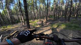
Pretty much a bit of everything in this loop. Located primarily in the lower portions of HammerFest so your climbing portions are average but good sections of corresponding down on some fun trails. A great way to see a cross section of intermediate trails.
Have Fun

Detailed Description
Prime Time Loop is a 5 mile popular intermediate route located near Parksville British Columbia. This mountain bike primary route can be used one direction and has a moderate overall physical rating. This route includes 14 trails. This route climbs 880 ft with a max elevation of 1,227 ft then descends -869 ft.

Trail Issues on Route

  • Minor Issue / Yellow: 2 trails (newest: Apr 24, 2026)
Local Trail Association
Local trail association
Arrowsmith Cycling Club (arrowsmithcyclingclub.com)
Please consider joining or donating to the local riding association to support trail development & maintenance.
Donate to earn trail karma!

Stats

  • Distance
    5 miles
  • Avg time
    1 hr 10 min
  • Altitude min
    473 ft
  • Altitude start
    537 ft
  • Altitude end
    548 ft
  • Climb
    880 ft
  • Descent
    -869 ft
  • Grade max
    -27.2%
  • Grade min
    43.3%
  • Distance climb
    2 miles
  • Distance down
    3 miles
  • Distance flat
    1,460 ft

28 Reviews & Comments


We hope you've been enjoying Trailforks!

Create a FREE account to view route comments and much more.

Route POI

CheckpointLap PointCheckpoint

Details

  • Riding area
  • Primary Activity
    Mountain Bike
  • Other Activities
    • E-Bike
  • Difficulty rating
    Blue
  • Route Type
    Loop
  • eBike Allowed
  • Bike type
    AM, XC
  • Direction
    One Direction
  • Physical rating
    Moderate
  • Ridelogs
    21

Directions

  1. Walk south on Park Access.
  2. Continue for 200 meters.
  3. Turn right to stay on Park Access.
  4. Continue for 300 meters.
  5. Turn right onto Walrus Lower.
  6. Continue for 100 meters.
  7. Turn right onto Wally Jr.
  8. Continue for 300 meters.
  9. Keep right to take Walrus.
  10. Continue for 600 meters.
  11. Turn right to stay on Walrus.
  12. Continue for 900 meters.
  13. Turn left onto Classic Road Climb.
  14. Continue for 50 meters.
  15. Turn right onto Powerline Access Road.
  16. Continue for 100 meters.
  17. Keep right to stay on Powerline Access Road.
  18. Continue for 20 meters.
  19. Keep left to stay on Powerline Access Road.
  20. Continue for 20 meters.
  21. Keep left to stay on Powerline Access Road.
  22. Continue for 20 meters.
  23. Keep straight to stay on Powerline Access Road.
  24. Continue for 20 meters.
  25. Keep left to stay on Powerline Access Road.
  26. Continue for 10 meters.
  27. Keep left to stay on Powerline Access Road.
  28. Continue for less than 10 meters.
  29. Bear right onto Sofa King.
  30. Continue for less than 10 meters.
  31. Turn right onto Jughead.
  32. Continue for 1 kilometer.
  33. Turn left onto locomotion.
  34. Continue for 300 meters.
  35. Bear left onto Con2.
  36. Continue for 200 meters.
  37. Turn right onto DownUnder.
  38. Continue for 900 meters.
  39. Turn left onto Outback.
  40. Continue for 900 meters.
  41. Turn left onto Locomotion.
  42. Continue for 600 meters.
  43. Turn right onto Jughead.
  44. Continue for 40 meters.
  45. Keep straight to stay on Jughead.
  46. Continue for 30 meters.
  47. Turn left to stay on Jughead.
  48. Continue for 10 meters.
  49. Turn right to stay on Jughead.
  50. Continue for 30 meters.
  51. Turn left to stay on Jughead.
  52. Continue for 20 meters.
  53. Keep left to stay on Jughead.
  54. Continue for less than 10 meters.
  55. Keep right to stay on Jughead.
  56. Continue for less than 10 meters.
  57. Keep left to stay on Jughead.
  58. Continue for 50 meters.
  59. Keep left to stay on Jughead.
  60. Continue for 30 meters.
  61. Keep straight to stay on Jughead.
  62. Continue for 60 meters.
  63. Keep left to stay on Jughead.
  64. Continue for 70 meters.
  65. Keep left to stay on Jughead.
  66. Continue for 20 meters.
  67. Keep right to stay on Jughead.
  68. Continue for 10 meters.
  69. Keep straight to stay on Jughead.
  70. Continue for 30 meters.
  71. Keep right to stay on Jughead.
  72. Continue for 10 meters.
  73. Keep straight to stay on Jughead.
  74. Continue for 30 meters.
  75. Keep straight to stay on Jughead.
  76. Continue for 10 meters.
  77. Keep left to stay on Jughead.
  78. Continue for 20 meters.
  79. Turn right to stay on Jughead.
  80. Continue for less than 10 meters.
  81. Keep left to take Link.
  82. Continue for 700 meters.
  83. Turn left onto Classic Road Climb.
  84. Continue for 70 meters.
  85. Bear right onto Puddle Lane Access Road.
  86. Continue for 100 meters.
  87. Turn right onto Pot Luck.
  88. Continue for 300 meters.
  89. Turn left onto Cranky.
  90. Continue for 400 meters.
Avg: 4.5 (2 votes)
close
3D
Trail Conditions
  • Unknown
  • Snow Groomed
  • Snow Packed
  • Snow Covered
  • Snow Cover Partial
  • Freeze/thaw Cycle
  • Icy
  • Prevalent Mud
  • Wet
  • Variable
  • Ideal
  • Dry
  • Very Dry
Trail Flow (Ridden Direction)
Trailforks scans users ridelogs to determine the most popular direction each trail is ridden. A good flowing trail network will have most trails flowing in a single direction according to their intension.
The colour categories are based on what percentage of riders are riding a trail in its intended direction.
  • > 96%
  • > 90%
  • > 80%
  • > 70%
  • > 50%
  • < 50%
  • bi-directional trail
  • no data
Trail Last Ridden
Trailforks scans ridelogs to determine the last time a trail was ridden.
  • < 2 days
  • < 1 week
  • < 2 weeks
  • < 1 month
  • < 6 months
  • > 6 months
Trail Ridden Direction
The intended direction a trail should be ridden.
  • Downhill Only
  • Downhill Primary
  • Both Directions
  • Uphill Primary
  • Uphill Only
  • One Direction
Contribute Details
Colors indicate trail is missing specified detail.
  • Description
  • Photos
  • Description & Photos
  • Videos
Trail Popularity ?
Trailforks scans ridelogs to determine which trails are ridden the most in the last 9 months. Trails are compared with nearby trails in the same city region with a possible 25 colour shades. Think of this as a heatmap, more rides = more kinetic energy = warmer colors.
  • most popular
  • popular
  • less popular
  • not popular
ATV/ORV/OHV Filter
Max Vehicle Width
inches
US Cell Coverage
Legend
cell carrier legend

Radar Time
Activity Recordings
Trailforks uses anonymized public activity data. ?
Activity Recordings
Trailforks uses anonymized public activity data. ?
Personal Heatmap
Activity Types
all / none
Options
2
Date range month
Winter Trails
Warning A routing network for winter maps does not exist. Selecting trails using the winter trails layer has been disabled.
Missing Trails
Most Popular
Least Popular
Trails are colored based on popularity. The more popular a trail is, the more red. Less popular trails trend towards green.
Jump Magnitude Heatmap
Heatmap of where riders jump on trails. Zoom in to see individual jumps, click circles to view jump details.
BC Backroad Status

Service Road Atlas is a free to use, community-driven service for viewing and creating reports on the numerous back-country service roads around B.C. and Alberta.

map legend
Slope Aspect
Direction the slope faces
Flat N NE E SE S SW W NW
Trails Deemphasized
Trails are shown in grey.
disable
Only show trails with no bike usage.
Enable
Suggested Layers
Based on selected activity type

    Save the current map location and zoom level as your default home location whenever this page is loaded.

    Save
    Trail transparency
    • Singletrack
    287
    148
    327
    359
    More exploring out at HammerFest | Parksville, BC
    More exploring out at HammerFest | Parksville, BC
    trail: Locomotion
    11:59 | 3 | comments: 0 | favs:
    May 30, 2026
    Hammerfest 2025 Island Cup Enduro Race #2
    Hammerfest 2025 Island Cup Enduro Race #2
    33:57 | 88 | comments: 0 | favs:
    May 16, 2025

    Recent Trail Reports Along Route

    statustraildateconditiondescription
    Wally Jr
    Jun 4, 2026 @ 1:41pm (America/Vancouver)
    2 days
    The Link
    Jun 4, 2026 @ 1:41pm (America/Vancouver)
    2 days
    Walrus Lower
    Jun 4, 2026 @ 1:41pm (America/Vancouver)
    2 days
    Pot Luck
    Jun 4, 2026 @ 1:41pm (America/Vancouver)
    2 days
    Locomotion
    Jun 3, 2026 @ 1:29pm (America/Vancouver)
    Jun 3, 2026
    reporter
    more reports »
    • By rapid-royTF Pro TrailsBC ACC & contributors
    • #18254 - 3,770 views

    Hit the Trail

    Open in App

    Get this route on your phone instantly.

    Download Route

    Save to wishlist, Garmin & download.