4.5 miles
Distance
1,145 ft
Climb
-1,148 ft
Descent
4,493 ft
High Point
-5 ft
Altitude change
3,440 ft
Altitude min
3,445 ft
Altitude start
3,438 ft
Altitude end
-86.9%
Grade max
48%
Grade min
2 miles
Distance climb
2 miles
Distance down
932 ft
Distance flat

How to find it
Head up the gravel road towards Island Lake Lodge, and it's the second yellow gate on your right, about 2.5km from when you leave the paved road. There's a little hump to the left of the gate you can ride over. Head up this double track until you get to the poweline, when you need to bear left onto the powerline road. Less than 100m of powerline road later, there's a right heading uphill. Get on that and start climbing When you get to the top of road, it ends with a turn around spot for vehicles, follow the trail into the forest and round to the right to reach the downhill section. Keep to the right-hand trail at the start of the down for the less steep version (they both join up pretty quick).
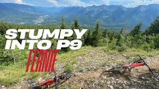
The trail
A serious climb from the road on a disused jeep track. One of those ones that everyone wants to clean, but not everyone does. There's a race up it every year. The record so far is 13 minutes to the top from the Island Lake Road...

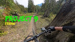
The down is a trail of three distinct sections - the first is a very cool section along a river bed - rocky, rooty and with little drops and rolls along the way. This then gives way to a very mellow flowing section through more open woods and fields, in which you can see some old stunts that should probably be avoided unless you've got off your bike and checked them out closely. Once you hit the powerline, the trail then heads modestly upwards for a short distance before launching into a roller-coaster of downs and flats that is pretty unique.

Detailed Description
Project 9 is a 4 mile popular expert route located near Fernie British Columbia. This mountain bike only route can be used one direction and has a moderate overall physical rating. This route includes 5 trails. This route climbs 1,145 ft with a max elevation of 4,493 ft then descends -1,148 ft.

Trail Issues on Route

  • Significant Issue / Amber: 1 trail (newest: Mar 30, 2026)
Route Supporters
Local Trail Association
Local trail association
Fernie Trails Alliance (www.fernietrailsalliance.com)
Please consider joining or donating to the local riding association to support trail development & maintenance.
Donate to earn trail karma!
Past Events

Stats

  • Distance
    4 miles
  • Avg time
    1 hr 26 min
  • Altitude min
    3,440 ft
  • Altitude start
    3,445 ft
  • Altitude end
    3,438 ft
  • Climb
    1,145 ft
  • Descent
    -1,148 ft
  • Grade max
    -86.9%
  • Grade min
    48%
  • Distance climb
    2 miles
  • Distance down
    2 miles
  • Distance flat
    932 ft

8 Reviews & Comments


We hope you've been enjoying Trailforks!

Create a FREE account to view route comments and much more.

Details

  • Riding area
  • Primary Activity
    Mountain Bike
  • Difficulty rating
    Black Diamond
  • Route Type
    Loop
  • Bike type
    AM
  • Direction
    One Direction
  • Physical rating
    Moderate
  • Ridelogs
    2
Avg: 2 (4 votes)
close
3D
Trail Conditions
  • Unknown
  • Snow Groomed
  • Snow Packed
  • Snow Covered
  • Snow Cover Partial
  • Freeze/thaw Cycle
  • Icy
  • Prevalent Mud
  • Wet
  • Variable
  • Ideal
  • Dry
  • Very Dry
Trail Flow (Ridden Direction)
Trailforks scans users ridelogs to determine the most popular direction each trail is ridden. A good flowing trail network will have most trails flowing in a single direction according to their intension.
The colour categories are based on what percentage of riders are riding a trail in its intended direction.
  • > 96%
  • > 90%
  • > 80%
  • > 70%
  • > 50%
  • < 50%
  • bi-directional trail
  • no data
Trail Last Ridden
Trailforks scans ridelogs to determine the last time a trail was ridden.
  • < 2 days
  • < 1 week
  • < 2 weeks
  • < 1 month
  • < 6 months
  • > 6 months
Trail Ridden Direction
The intended direction a trail should be ridden.
  • Downhill Only
  • Downhill Primary
  • Both Directions
  • Uphill Primary
  • Uphill Only
  • One Direction
Contribute Details
Colors indicate trail is missing specified detail.
  • Description
  • Photos
  • Description & Photos
  • Videos
Trail Popularity ?
Trailforks scans ridelogs to determine which trails are ridden the most in the last 9 months. Trails are compared with nearby trails in the same city region with a possible 25 colour shades. Think of this as a heatmap, more rides = more kinetic energy = warmer colors.
  • most popular
  • popular
  • less popular
  • not popular
ATV/ORV/OHV Filter
Max Vehicle Width
inches
US Cell Coverage
Legend
cell carrier legend

Radar Time
Activity Recordings
Trailforks uses anonymized public activity data. ?
Activity Recordings
Trailforks uses anonymized public activity data. ?
Personal Heatmap
Activity Types
all / none
Options
2
Date range month
Winter Trails
Warning A routing network for winter maps does not exist. Selecting trails using the winter trails layer has been disabled.
Missing Trails
Most Popular
Least Popular
Trails are colored based on popularity. The more popular a trail is, the more red. Less popular trails trend towards green.
Jump Magnitude Heatmap
Heatmap of where riders jump on trails. Zoom in to see individual jumps, click circles to view jump details.
BC Backroad Status

Service Road Atlas is a free to use, community-driven service for viewing and creating reports on the numerous back-country service roads around B.C. and Alberta.

map legend
Slope Aspect
Direction the slope faces
Flat N NE E SE S SW W NW
Trails Deemphasized
Trails are shown in grey.
disable
Only show trails with no bike usage.
Enable
Suggested Layers
Based on selected activity type

    Save the current map location and zoom level as your default home location whenever this page is loaded.

    Save
    Trail transparency
    • Singletrack
    • Unpaved
    43
    147
    68
    40
    youtuber BRUTAL CLIMB INTO EPIC DESCENT! Stumpy into...
    BRUTAL CLIMB INTO EPIC DESCENT! Stumpy into Project 9!
    trail: Project 9
    15:32 | 144 | comments: 0 | favs:
    Aug 3, 2025
    Project 9 - Fernie
    Project 9 - Fernie
    trail: Project 9
    8:48 | 275 | comments: 0 | favs:
    Apr 6, 2025

    Recent Trail Reports Along Route

    statustraildateconditiondescription
    Project 9
    Jun 14, 2026 @ 1:26pm (America/Edmonton)
    Jun 14, 2026
    Excellent shape, super wet through the first rock garden after momma’s way, then nice dirt on the pink line to the bottom.
    Project 9 Access
    Jun 14, 2026 @ 1:24pm (America/Edmonton)
    Jun 14, 2026
    1st steep a touch greasy. Great on the rest of climb.
    Lazy Lizard Connector
    Jun 3, 2026 @ 11:52am (America/Edmonton)
    Jun 3, 2026
    Trees cleared
    Lazy Lizard from Island Lake parking lot
    Mar 30, 2026 @ 11:46am (America/Edmonton)
    Mar 30, 2026
    Island Lake Road
    Jul 20, 2020 @ 11:28am
    Jul 20, 2020
    more reports »
    • By vinniemo & contributors
    • #2248 - 3,800 views

    Hit the Trail

    Open in App

    Get this route on your phone instantly.

    Download Route

    Save to wishlist, Garmin & download.